| |
Introduction |
|
 
|
| On a recent (April 19-May 2, 1999) trip to the
Arctic, personnel from NASA's Goddard Space Flight Center chose the
North Pole as the unique site from which to demonstrate how new
communications technologies and the Internet now make it possible for
scientists working in very remote locations to send and receive data
using NASA communications satellites. Accompanied by nine other
engineers, scientists, and outreach personnel (also from NASA's GSFC),
we traveled to Resolute Bay and Eureka, Canada, before heading north to
the "top of the world" to broadcast the first ever live webcast from the
North Pole. We had two main objectives on this expedition: (1) to
demonstrate the new communications technologies that made our live
webcasts possible, and (2) to take measurements of various aspects of
the Arctic environment. What is most unique about this expedition is
that students from around the world participated in some of our
scientific activities via their personal computers. This "virtual field
trip" involved the exchange of dialogue from their computers while
hearing responses to their questions as they watched live video
demonstrations by the expedition team.
|
|

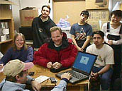
Claire Parkinson, Steve Graham,
Tim Roberts and students from the Qarmartalik School pause for a picture
during a test webcast from the Environment Canada facilities in Resolute
Bay.
|
Communications and Science
During the
expedition, we demonstrated three new communications instruments that
scientists can use while conducting field experiments: TILT (TDRS
Internet Link Terminal), ECOMM (Early Communications), and PORTCOMM
(Portable Communications). Each of these new instruments has design
advantages and disadvantages. For instance, the TILT system transmits a
high-quality signal appropriate for television or World Wide Web
broadcasts at the relatively high rate of 1 megabit per second. The
ECOMM system also transmits a television and Web broadcast quality
signal, but at the much slower rate of 128 kilobits per second.
However, at a fraction of the weight of TILT and consuming only
one-third the power, ECOMM is much easier to transport for webcasts from
remote locations. The PORTCOMM system yields an added communications
capability while on the move. While moving in a car, a helicopter, and
even a dogsled, we were able to send data files at a rate of 4.8
kilobits per second (again, much slower than the previous system).
All three communication packages were developed at GSFC and use NASA's
Tracking and Data Relay Satellite-1 (TDRS-1) to complete the
communication links. Launched in 1983, TDRS-1 is currently in a
geosynchronous orbit (an orbit in which the orbital velocity of the
satellite matches the spin rate of the Earth) that is inclined
sufficiently to make it visible to the polar regions of the globe four
hours each day, with a maximum elevation of 1.6 degrees above the
horizon.
In addition to the communications element, and as an integral
component of the expedition, scientific observations and measurements
were made. The team collected ozone measurements with a hand-held
Microtops photometer provided by Gordon Labow of GSFC Code 916 and Global
Positioning System (GPS) measurements with a Trimble GPS Unit provided
by Steve Cohen and Erricos Pavlis of GSFC Code 921. Sea ice
thickness measurements were made through holes drilled with both powered and manual ice
augers. The ozone measurements will be compared with satellite
observations made by NASA's Total Ozone Mapping Spectrometer (TOMS), as
checks on both the Microtops and the satellite data. The GPS
measurements from Resolute Bay will be used, in conjunction with
additional measurements after several years, to examine glacial rebound,
i.e., the uplifting of the land surface in response to the removal of
the weight of the Pleistocene ice sheet.
The GPS measurements from the North Pole will be compared with
corresponding measurements taken concurrently at the South Pole and in
equatorial locations, to allow students to quantify easily the polar
flattening of the Earth, i.e., the fact that the distance from the North
Pole to the South Pole is less than the equatorial diameter of the
Earth. The sea ice thickness measurements are being compared with other
Arctic ice thickness measurements made from the surface and from
submarines (sonar data). In addition, soil samples were collected, air
temperatures were measured, and cloud type and cloud cover observations
were recorded in conjunction with the protocols set forth by the Global
Learning and Observations to Benefit the Environment (GLOBE) program and
Elissa Levine of GSFC Code 923. These measurements added a new location
for the global atmospheric and soil measuring efforts of the GLOBE
program, as students worldwide will compare our data with data from
their local schools.
 From GSFC to the Arctic From GSFC to the Arctic
 Introduction Introduction
|
|

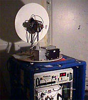
The TDRS Internet Link Terminal
(TILT) inside the radome at the Environment Canada facilities in
Resolute Bay.
|

