Signs of Good Breeding |
||||
Now that they had proven that coarse-resolution data could be used for routine monitoring, the next step was to streamline the process even further to make it useful to ground survey crews and resource managers in remote and low-tech sites. Hielkama decided to come up with a way to combine the daily NDVI values in any given area into a single locust indicator. “In the beginning,” says Tucker, “we were processing the data here at Goddard every ten days. Because there was no digital network, we created the vegetation maps here and took photos of them. Then I got in my car and drove into downtown D.C. to the FAO office where the photos would go into the FAO diplomatic pouch to be transmitted overnight to Rome and FAO. This went on for almost seven years.” The results would be interpreted by Tucker’s colleagues in Rome, who sent the information out via teletype machines. They needed to simplify the information as much as possible. |
||||
| ||||
One approach to combining NDVI data is simply to average all the NDVI values within a certain area. The trouble with that is that when the changes you are looking for occur on a small scale, such as in a narrow wadi surrounded by desert, averaging might cause your vegetation to “disappear.” Instead, Hielkama developed what he called the Potential Breeding Activity Factor. This breeding factor considered the NDVI value of each pixel in a given area and placed it into one of four categories from high NDVI to low. Then he created a weighted score for all the pixels in the area by multiplying the total number of pixels in each category by a different number. The highest NDVI category was multiplied by 1000, the next by 100, the next by 10, and the lowest category by 1. All these scores were added up and divided by the total number of pixels in the area. By assigning progressively more importance to areas with higher amounts of vegetation (higher NDVI), the calculation produced a measure of how likely a particular area was to become a hot spot for plague formation. The key advantage was that it reduced the volume of data that needed to be transmitted operationally. To demonstrate that their streamlined approach worked, the researchers applied their remote-sensing techniques to a retrospective analysis of a locust plague that had occurred in West Africa between 1980 and 1981. Using even coarser, 4-km-resolution data from the NOAA-6 AVHRR instrument, they calculated the potential breeding factor for numerous areas in the southern Sahara Desert in West Africa where locust upsurges were known to have begun. Comparing their results to rainfall observations and ground surveys of locust populations conducted during the upsurge, the scientists found that not only did the breeding factor calculated using the coarse-resolution data correlate with the documented field locations of upsurge populations, but they also discovered that the initial upsurge was quite likely localized to a small area. Controlling the upsurge in this 600-square-kilometer (230-square-mile) area with spraying would likely have been very successful at preventing a plague that lasted several months and ultimately affected 600,000 square kilometers (230,000 square miles)! |
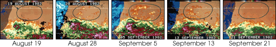
Tucker and Hielkama used AVHRR data from 1982, which corresponded with a locust outbreak, to validate their observations. These images show a ‘flush’ of vegetation (orange and yellow), which appeared and subsided in only a month. (Images courtesy Compton Tucker) |
|||