 | |||
Astronauts on board the International Space Station (ISS) have many tasks, but a consistent favorite is taking photographs of Earth. The ISS astronauts don’t just take digital images randomly. The photos they shoot are part of a well-defined program of data collection coordinated through the Crew Earth Observations team at Johnson Space Center. Current research targets include glaciers, deltas, urban areas, coral reefs, megafans (inland deltas), and long-term ecological monitoring sites. Dynamic events such as hurricanes, dust storms, volcanic eruptions, and fires are also imaged when possible. The database of astronaut photography is freely accessible via the Internet. The Crew Earth Observations team selects science targets and uploads them to the ISS crew daily based on the current orbital position of the ISS, local sun angle, predicted local weather conditions, and the task schedule. Satellites, such as Landsat and Terra, that are in polar (pole-to-pole) orbits pass over the same location on the globe at approximately the same time every day. The inclined (angled), equatorial orbit of the ISS and having a “human in the loop” to point the camera allow for a wide variety of local sun angles and ground resolutions (levels of detail) for science targets. These unique characteristics of astronaut photography provide a dataset that includes both scientific and aesthetic, or artistic, value. This duality is expressed in ISS Expedition 10 Commander Leroy Chiao’s ten favorite photos (see also Expedition 10 Earth Observation Photos; and Shooting for the Heart: Astronaut Finds Passion for Photography in Space). |
| ||
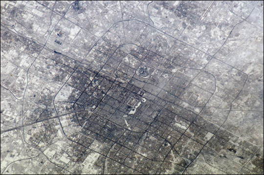 | |||
Snow cover shows the boundaries between built-up (gray) areas versus vegetated and open space (white) within the large city of Beijing (Peking), China. The Forbidden City is visible in image center. Astronaut photograph ISS010-E-18196 was acquired February 18, 2005, with a Kodak 760C digital camera with a 400 mm lens. Two of the world’s great cities, New York and Beijing, were among those imaged by Leroy Chiao during Expedition 10. Large urban centers such as these serve as global economic, social, and cultural centers. The establishment and growth of cities also alters local and sometimes regional climate patterns, hydrology, and ecology. Replacement of existing soil and vegetation by asphalt and concrete fosters the creation of urban “heat islands,” increases surface water runoff, decreases groundwater recharge, and fragments pre-existing ecosystems. |
High-resolution image (1.9 MB JPEG) | ||
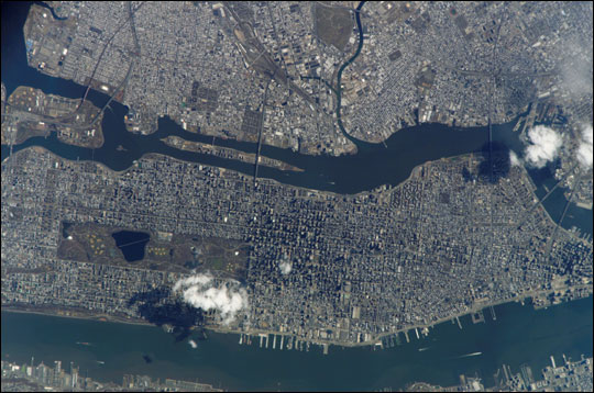 | |||
Manhattan Island and its easily recognizable Central Park (center left) are featured in this image. Some of the other New York City boroughs (including parts of Queens and Brooklyn) are also shown, as are two small sections of the New Jersey side of the Hudson River (lower left and lower right). Astronaut photograph ISS010-E-21487 was acquired March 26, 2005, with a Kodak 760C digital camera with an 800 mm lens. While cities represent people’s most visible alteration of Earth’s surface, numerous other regions of the planet are also directly or indirectly impacted by human activities. Photography of glaciers, deserts, coastal regions, and lakes provide data for tracking changes. Astronauts document the advance and retreat of glacial ice due to climate change; location and structure of dune fields related to desertification; changes to coastlines and deltas following hurricanes or human development; and changes to lakes and rivers related to land cover and land use change. Digital astronaut photographs only record data in the visible red, green, and blue wavelengths of light (not infrared, for example), but the variety of acquisition times and spatial resolutions make these data useful additions to more traditional multispectral and hyperspectral datasets from satellites and other remote-sensing platforms like aircraft. |
High-resolution image (1.7MB) | ||
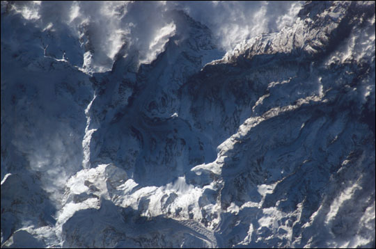 | |||
A portion of the Himalaya range and several glaciers are featured in this image. Astronaut photograph ISS010-E-15457 was acquired February 1, 2005, with a Kodak 760C digital camera with a 400 mm lens. |
High-resolution image (1.O MB JPEG) | ||
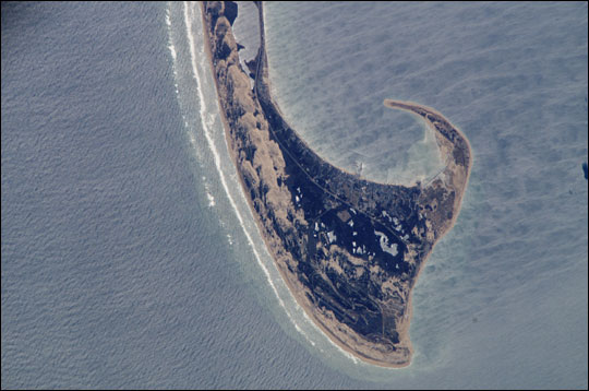 | |||
The northernmost parts of the Cape Cod National Seashore, Massachusetts, are featured in this image. Wave refraction patterns are present near the edge of the Cape (bottom), and coastal dune fields are visible at image center. Astronaut photograph ISS010-E-21965 was acquired March 30, 2005, with a Kodak 760C digital camera with an 800 mm lens. |
High-resolution image (1.4 MB JPEG) | ||
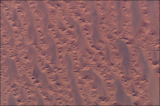 | |||
This image captures a portion of the Grand Erg Oriental (Eastern Sand Sea) in Algeria. Astronaut photograph ISS010-E-10124 was acquired December 11, 2004, with a Kodak 760C digital camera with a 400 mm lens. |
High-resolution image (1.3 MB JPEG) | ||
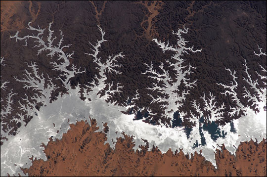 | |||
Egypt’s Lake Nasser was created by completion of the Aswan High Dam in 1970. Sunglint (light reflected off the water surface) on the lake makes it easily visible. Astronaut photograph ISS010-E-14618 was acquired January 23, 2005, with a Kodak 760C digital camera with a 400 mm lens. |
High-resolution image (1.5 MB JPEG) | ||
