An Orbital Tour |
|||
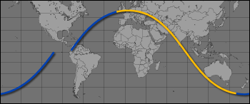
Now I thought I’d take you on a guided tour of an orbit around the Earth. Take a globe and imagine a hoop representing our orbit around the equator. Now tilt the hoop by 51.6 degrees, and that is what our orbit track looks like. The Earth rotates on its axis every 24 hours inside the hoop, while we go much faster around the hoop, making a lap every 90 minutes. If we start our tour along the inclined hoop from over the equator, we will at first be moving in a northeasterly direction, and by a quarter of an orbit later will be at the northernmost point of our orbit traveling in an easterly direction. The orbit then becomes southeast, we cross the equator into the Southern Hemisphere and by the time we reach the southernmost point of our orbit we are again traveling due east. The final quarter of an orbit takes us back to the equator, but not over the original point since by then the Earth will have rotated one sixteenth of a revolution in the 90 minutes (or one sixteenth of a day) it took us to travel once around. If our orbit hoop was completely fixed in space (which it is not quite exactly), then we will see 16 different orbit tracks each day with the pattern repeating itself every day. |
|||
One of my favorite orbit tracks starts over the equator southwest of Hawaii. At this point, looking down you will just see water and clouds. The Pacific Ocean is a deep bright blue color, and typically over the equator there are scattered bright white clouds. In about 3 minutes, off to the left of our track you can see the islands of Hawaii. You can easily see the standing clouds over the mountains as the trade winds blow up the mountainsides. When you fly right over the top of the islands you can look down and see the city of Honolulu near Pearl Harbor. If the weather is good and the air is clear (and it almost always is in Hawaii) you can see objects as small as maybe a quarter of a mile in size with your bare eyes. What matters most for spotting objects is usually the contrast with surrounding areas. For instance there is a large runway (8R if you care to know the name) at Honolulu International Airport that has been built out on the edge of the water that you can very easily see from space since it is easy to pick out against the blue color of the water. With binoculars you can see much smaller objects like ships and individual buildings! |
This map shows the ground track of a single space station orbit. The next orbit will be shifted to the west (Learn more with the ISS Orbit Tutorial). | ||
 | |||
After Hawaii passes off to the left, again you see mostly ocean for a few minutes as we head northeast towards the California coast. We cross the coastline just north of San Francisco, and looking down you can see the cities of San Francisco, Oakland, and San Jose surrounding San Francisco Bay. Cities have a grayish color, probably because of all the asphalt and buildings. They are not always easy to spot unless they are located near an easily recognizable feature (like San Francisco Bay) or the surrounding areas have a very different color or brightness (cities surrounded by forests for instance). |
The Honolulu International Airport runway juts into the water on the left side of this frame. In the center is Ke’ehi Lagoon and on the right is Sand Island. ISS007-E-16807 (October 8, 2003, 800 mm lens) | ||
 | |||
In the bay near Fremont (where my parents live) are huge maroon red ponds which are very easy to spot from space. This color is from bacteria growing in the ponds where they evaporate water to collect salt. Salt evaporation ponds near Great Salt Lake, Utah, have a similar color. Looking to the left of our track you can see a line of white snow-capped volcanoes running up the Cascade mountain range and Washington State in the distance. To the right you can look down the central valley of California to the Baja Peninsula in Mexico. |
In this photograph of the San Francisco Bay area taken from the International Space Station during Expedition 4, the gray urban footprint of San Francisco, Oakland, San Jose, and their surrounding suburbs contrasts strongly with the green hillsides. ISS004-E-10288 (April 21, 2002, 105 mm lens) | ||
 | |||
We continue northeast heading over the Rocky Mountains, over Yellowstone Park, and up into Canada. I remember that when I lived in Colorado, we would get big afternoon thunderstorms in the summertime. From space, you see that this area is covered with isolated thunderhead clouds that pop up like mushrooms in the late afternoon. Actually, thunderstorm clouds look more like flattened cauliflower heads when viewed from above. |
Ed took this detailed photograph of the San Francisco bay salt ponds and the adjacent urban and industrial areas. ISS007-E-8738 (June 30, 2003, 800 mm lens). | ||
 | |||
Southern Canada is covered with a myriad of small lakes. If the sun is overhead, you can see the sun glint off the lakes, rivers, and streams—briefly lighting them up as the reflection point moves across the surface of the Earth with you. Looking left we pass Hudson Bay. Even now in the summertime there is ice on parts of the bay. To the right pass the Great Lakes. One thing that is surprisingly easy to see from space is airplane contrails, the white condensation trails left behind high-flying jets. You can see the white lines converging on Chicago from all directions. Continuing eastward, we pass over the St. Lawrence River, over Newfoundland, and then out over the Atlantic Ocean. The total time to cross North America has been about 12 minutes. |
These morning thunderstorms formed over the coast of the southeastern United States. ISS007-E-14547 (September 8, 2003, 400 mm lens) | ||
 | |||
Lately, wide expanses of clouds have been covering the North Atlantic Ocean like a blanket. These large weather system clouds look like a white 1970s era textured carpet with bumps and ridges and the occasional thunderhead cloud popping up through. As we head southeast towards the coast of Africa, you can see in the distance the red deserts of the western Sahara. The color here is a chalky red, almost like the color of red bricks. Recently, large dust storms over the desert have been blurring out any detail on the ground. We skim the coast heading southeast over Sierra Leone and Liberia, and continue towards the Cape of Good Hope at the southern tip of Africa. |
Sunlight reflects off of the lakes of Quetico Provincial Park, Ontario. The area lies between Lake Superior and Lake of the Woods, just north of the U.S.-Canada border. The long vertical clouds in the image are condensation trails produced in the wake of jet airplanes, probably from heavy air traffic around Chicago O’Hare. ISS007-E-12858 (August 17, 2003, 180 mm lens). | ||
 | |||
If Hawaii is in daylight, then Eurasia will be on the night side. Since we orbit the Earth 16 times a day, we see 16 sunrises and sunsets each day. Looking backwards towards the horizon you can see the sunset. Sunsets and sunrises are beautiful, with very thin, distinct color layers in the atmosphere. They range from orange and red near the surface to various shades of blue, purple, and finally black. |
Dust blowing from the Sahara Desert obscures the country of Western Sahara. In this view the Space Station is over the Atlantic, and Ed was looking southwest toward the horizon. On the right winds are causing partial Von Karman vortices to form downwind of the Canary Islands. ISS007-E-8259 (June 25, 2003, 50 mm lens). | ||
 | |||
The sun rises and sets fairly quickly at the speed we are flying, taking just a few minutes for us to go from dark to light or vice versa. Looking down on the ground you can see the line dividing the day and night sides of the Earth. If there are high clouds, you can often see the long shadows they cast when the sun is low in the sky. |
This detailed side view of the Earth’s atmosphere shows the spectacular colors of the sun’s rays at sunset. High clouds have formed at the top of the Earth’s orange-colored troposphere. Ed has also photographed noctilucent clouds, which occur above the mesosphere. ISS007-E-11204 (July 28, 2003, 800 mm lens) | ||
 | |||
At sunset over the Pacific Ocean, anvil tops of thunderclouds cast long shadows. ISS007-E-10807 (July 21, 2003, 35 mm lens). | |||