The View from Space | |||
Bindschadler started using the perspective of remote sensing over 25 years ago. “My first season in Antarctica, I didn’t realize I also came with my preconceived notions about how one studies glaciers, based on what I had done in my post-graduate work. I knew Alaskan glaciers were big, but Antarctica was just a totally different scale, and you could not be very effective in the time you had to spend there unless you included satellite data,” he recalls. Satellite remote sensing complements fieldwork both before and after a trip to Antarctica. “It gives you the big picture before you go. You can see what’s uniform and what’s changing and decide where you want to do fieldwork,” Bindschadler explains. “After you get back, it helps you put your measurements into a broader context. So remote sensing permeates every aspect of the planning, the conduct, and the analysis of the fieldwork.” |
|||
Based on his decades of experience with studying frozen landscapes with satellite data, Bindschadler suspected that a remote-sensing perspective could guide the traverse team away from the most crevasse-filled areas and enhance their safety. The snow bridges that cover crevasses often sag. The sags are so slight that, from the ground, they can be hard to detect, but Bindschadler knew from experience the right satellite might be able to find many of them from space. After taking Blaidsell’s call, Bindschadler and his associate, Patricia Vornberger, began poring over the two most promising satellite data sets: radar data from the RADARSAT Antarctic Mapping Project (RAMP) and multi-spectral data from the Advanced Spaceborne Thermal Emission and Reflection Radiometer on NASA’s Terra satellite. In 1997, Canada’s RADARSAT-1 satellite collected images that led to the first high-resolution map of the entire continent of Antarctica. RADARSAT also offered an advantage not available from every satellite: it could see through clouds. Over the past several years, RAMP data have done a reliable job of finding crevasses in Antarctica, so it was logical for Bindschadler to turn to these data again. |
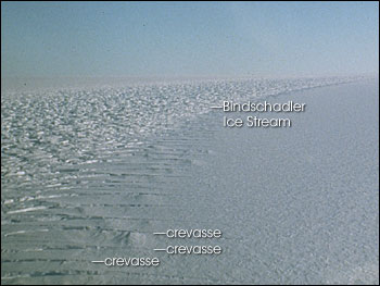
A field of crevasses fades into the distance on the Ross Ice Shelf. The smooth ice on the right is frozen to the bedrock. The rough ice on the left and in the distance is part of the Bindschadler Ice Stream (formerly named Ice Stream D). The strain of movement causes crevasses to form in this ice. (Photo courtesy Ted Scambos, National Snow and Ice Data Center) | ||
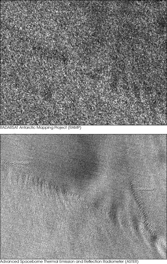 | |||
The Advanced Spaceborne Thermal Emission and Reflection Radiometer (ASTER) sensor flies on NASA’s Terra satellite. The high-resolution sensor is a cooperative effort between NASA, Japan’s Ministry of Economy, Trade and Industry, and Japan’s Earth Remote Sensing Data Analysis Center. “By pure serendipity, we had some ASTER images of the same area because we were studying the dynamics of the nearby Whillans Ice Stream,” Bindschadler says. “Since we had them in our lab, we could quickly take a look at them.” While Bindschadler searched the RAMP data, Vornberger concentrated on ASTER data. The two quickly discovered that ASTER data showed crevasses where RAMP didn’t. A close look at the ASTER imagery shows a series of crevasses on the ice shelf. From space, each crevasse looks almost like a giant had pressed his thumbnail into the surface of the ice. RAMP imagery of the same area shows larger ice shelf features, but the crevasses aren’t apparent. ASTER has a higher resolution than RAMP (15 meters compared to 25 meters), and this may have given it an edge in finding crevasses. Likewise, ASTER “sees” the same kind of light that the human eye sees, whereas RAMP looks at a different part of the electromagnetic spectrum. So ASTER’s images may be more intuitive to our eyes. Armed with Bindschadler and Vornberger’s crevasse predictions, the traverse team was back on track. “We gave them the waypoints we felt very confident were safe for surface travel,” Bindschadler says. “They followed those, but they didn’t trust us completely. I don’t blame them because they had already had some unpleasant surprises.” Blaisdell confirms that satellite imagery is no silver bullet. “It’s safe to say that if you see a crevasse feature on satellite imagery, you’ll find a crevasse. But you cannot assume that if the satellite doesn’t see a crevasse, there won’t be one. For a traverse team, satellite imagery is one of the many tools we use.” Silver bullet or not, Blaisdell estimates that the ASTER imagery saved the traverse team a tremendous amount of time. “If ASTER couldn’t have seen the crevasses, it would have taken us probably a full season to probe our way through that area using ground tools,” he says. |
Although RAMP has a history of finding large crevasses, this RAMP image (top) shows no crevasses while an ASTER image of the same region shows many (bottom). (Images courtesy Robert Bindschadler, NASA GSFC) | ||
Once out of the crevasse field, the traverse team marched steadily up the Leverett Glacier and toward the pole. By 8:30 p.m. on January 4, 2005, all the tractors in the caravan had driven up onto the polar plateau. Everyone wanted to continue all the way to South Pole Station, and they had the fuel to get there. But they didn’t have enough for the round trip to the pole and all the way back to McMurdo. The U.S. Antarctic program could have flown the fuel to South Pole Station, but bad weather put the supply flights behind schedule. The traverse team had to turn back. Team members were disappointed at not reaching the pole, but the traverse team had nevertheless far exceeded its own expectations, thanks in a large part to ASTER data. Bindschadler explains, “This shows the value of using imagery to assess the safety of an area, especially new areas we haven’t seen before. Satellite imagery is a perfect tool that’s underutilized. We really need to appreciate that fact and use it more often.”
|
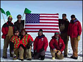
The Antarctic Traverse team members pose for a picture at the southernmost point of their trek. (Photo courtesy John Wright and The Antarctic Sun) | ||
