Tectonic Processes |
|||
East Africa is of intense interest to geoscientists investigating the formation of ocean basins and the rifting of continental plates. Conditions in some areas, such as Ethiopia, have prevented the direct inspection of the area by western field scientists for more than a decade. The broken terrain has handicapped development of transportation, leaving extensive areas isolated and inaccessible to motor vehicles. Because of these limits to research, the East African Rift is a focus for Crew Earth Observations. Photographs taken from orbit permit observation and interpretation of both geological and environmental conditions in the region. |
|||
| |||
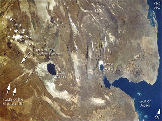
The faults of the Red Sea system (trending North-Northwest), those of
the Ethiopian rift (Northeast), and those of the Gulf of Aden
(West-Southwest) originate in this region. The rift triple junction and
the active volcanism in the area reflect stretching of the Earth's crust
above a rising plume of hot mantle material. This rifting of continental
crust is analogous to the process that separated the Americas from
Eurasia and Africa to form the Atlantic Ocean. |
The Red Sea, Gulf of Aden, and Ethiopian rift systems originate in the Afar region of East Africa. Dark lava flows cut by long, straight faults characterize the terrain (STS41G-32-16). As the rifting continues over geologic time, Lake Assal will eventually become an extension of the Gulf of Aden. | ||
East African rift zones that will be a focus of the Crew Earth Observations project include the Rukwa transform fault zone, Tanzania; Mt. Kilimanjaro, Kenya; and the rift triple junction in Ethiopia. Analogous Features on Earth, Moon and Mars
|
|||
| |||
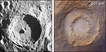
Terrestrial features for which there are morphological analogues on
Earth’s Moon and Mars are selected as Crew Earth Observations
sites. These features include impact craters, volcanoes, dune fields,
old shorelines, and expanses of layered rocks (see Canyons, Craters
and Drifting Dunes). |
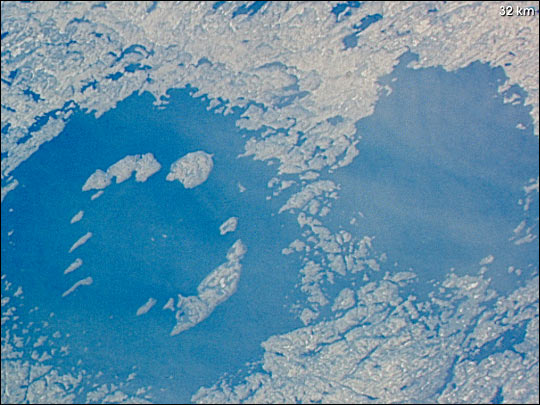
Clearwater Lake W., Canada, photographed from the Space Shuttle (STS61A-35-86). | ||
By comparing detailed photos and high-resolution images of the Earth, Moon, and Mars, scientists can define the dominant processes that have shaped the landscapes of the three planetary bodies. Such analyses provide essential data for landing-site selection and for framing scientific objectives for robotic and human missions to Mars. They also aid in the identification of potentially troublesome environmental elements near proposed landing sites, such as persistent dust storms, steep slopes, or bouldered terrain. |
far left: Tycho Crater, The Moon (Lunar Orbiter image V-125M). left: Lowell Crater, Mars as seen by the Mars Orbital Camera. | ||