Sampling the Smog |
|||
“We wanted to get smack into a place that’s on fire and take measurements,” says Thompson. She chose Lusaka, Zambia, a town of about 1.5 million stationed in the center of the burning, roughly 1,500 miles (2,400 kilometers) northeast of the Cape of Good Hope. The work was conducted under the umbrella of the Southern African Regional Science Initiative (SAFARI 2000). One of SAFARI’s two goals was to refine scientists’ ability to track ozone, aerosols, land cover types, and other features of the land and the atmosphere from space. The other goal was to study the impact of human activities on the atmosphere and ecosystem of southern Africa. |
|||
Thompson and her team, made up of herself, one Canadian, and one South African, set up their laboratory on the grounds of the Zambian Meteorological Department (ZMD). From September 6 to 11, 2000, the researchers acquired measurements of ozone from the Earth’s surface to many kilometers above sea level. They launched a rapid series of balloons carrying a lightweight ozone-measuring device called an “ozonesonde” along with a standard radiosonde, which gathers pressure, humidity and temperature readings. As the balloons climbed through the troposphere over a period of about an hour and a half, the instruments radioed measurements back to Thompson’s team. Typically, the balloons expanded to twenty times their original size before exploding. The instruments would then parachute to Earth. Most days, winds were so light that the balloons did not drift far before popping, and surprised Lusakans would call local authorities to report that strange objects had parachuted into their gardens. ZMD issued rewards for the return of the instruments. One sonde, however, was sent in by the ministry that oversees national security. “The battery for the ozone pump was still operating and the finder thought it was a bomb,” Thompson explains. “The ZMD was quick to reassure the authorities.” |
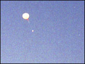 Anne Thompson and the other scientists in Zambia measured ozone profiles using instruments strapped to weather balloons. The balloons climbed through the atmosphere for an hour and a half, before popping at an altitude of about 30km. (Photograph courtesy Anne Thompson, NASA GSFC) | ||
Though Thompson expected the ozone measurements to be elevated due to the fires, the readings she received were surprisingly high. In the absence of burning, ozone levels at ground level in Lusaka are typically less than 20 parts per billion by volume (ppbv). In other words, if one gathered one billion molecules from the area when the savanna was not burning, 20 would be ozone. During most of the days Thomson took readings, however, ground level ozone reached over 90 ppbv. They were the highest levels measured on the ground in southern Africa. “Not only were ozone levels much greater than we expected,” Thompson states, “it appeared that one third to half the ground level ozone came from the various local burning practices, trash fires, charcoal making, and thousands of poorly maintained cars.” In the United States, ozone is considered to be Code Red if ozone levels are above 90 ppbv on average for eight hours, as they were in Africa. While U.S. cities such as Washington, DC, are chronically over the limit in the summer months, the Washington, DC, metropolitan area, which is four times larger than Lusaka, has many more cars per capita. At the same time, Thompson’s team detected smoke and aerosol levels over Lusaka worse than anything seen in the United States. The constant haze over the city causes chronic irritation to the eyes and throat. “This should be a big health concern,” says Thompson. Perhaps even more surprising was that as high as the ozone levels were on the ground, they were even higher further up in the atmosphere. On any given day, ozone levels would remain relatively stable until the balloons reached an altitude of 2 to 3 kilometers (1.2 to 1.9 miles). Here the amount of ozone would shoot up to as high as 120 ppbv. The readings would stay this high until about 5 kilometers (3.1 miles) above sea level before sharply decreasing to lower values up through the remainder of the troposphere. |
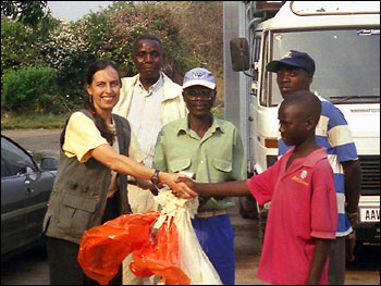
Residents of Lusaka were occasionally surprised when a deflated balloon, complete with instruments, landed in their yards. Thompson (left) and the Zambian Meteorological Department paid a fee for the instruments’ safe return. (Photograph courtesy Anne Thompson, NASA GSFC) | ||
 |
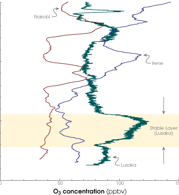
Thompson compared her Lusaka measurements to similar ones taken at the same time by SAFARI researchers in the larger cities of Nairobi, Kenya, and Pretoria, South Africa. The ozone levels in Lusaka were appreciably higher, especially in the 3 to 5 kilometer (1.9 to 3.1 mile) range. “So even with the places that we’ve watched using the sondes, Lusaka was a standout in pollution,” says Thompson. The high ground-level ozone readings were easily explained given Lusaka’s position in the heart of the burning. As to the unusual spike in ozone from the 3 to 5 kilometer (1.9 and 3.1 mile) range, Thompson says she had seen this phenomenon before. “In the late 1980s, a NASA Langley researcher, Jack Fishman, noticed an ozone hotspot over the south Atlantic in August and September,” she said. There isn’t much in the way of industry, automobile traffic, or biomass burning in the middle of the ocean, and the high ozone values corresponded with the burning in southern Africa. Researchers came to the conclusion that some type of circulation pattern over Africa must be carrying the ozone out over the water. |
Thompson measured ozone as it varied with increasing altitude. In Lusaka the ozone concentration a few kilometers up increased dramatically over the already high surface levels. The ozone was so thick, in fact, that it must have travelled from other parts of Africa to arrive over Lusaka. (Graph courtesy Anne Thompson, NASA GSFC) | |
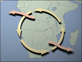
In the early 1990s, Thompson traveled to Africa with Fishman to conduct more experiments. Thompson said that their research pointed to the existence of a large circular atmospheric motion over south central Africa. She says, however, they did not have enough evidence. It took SAFARI 2000 to prove the phenomenon existed. The spike in ozone at 3 to 5 kilometers (1.9 to 3.1 miles) above sea level could be explained by what Thompson describes as a gyre. Centered roughly on northern Botswana and central Zambia, this southern African gyre is a large ring of swirling air that passes over Nambia, northern South Africa, southern Mozambique, Zambia, and Angola. The gyre can stay intact for weeks at a time, held in place by temperature inversions at the top and bottom of the ring. Ozone from fires all across southern Africa rise up and mix into the layer of air in the gyre, which can then carry the pollution hundreds of miles. Sometimes parcels of polluted air spin off, streaming out over the Atlantic, the Indian Ocean, and even the Pacific. “Most of the ozone stays spinning in the inversion layer though,” Thompson explains. “And ozone from fires in western Zambia, Angola, and the other countries on fire slowly builds up. The peak location was around Lusaka.” Though ozone in the gyre is not a health threat, it may have an effect on climate. The gyre could be causing ozone to build up high in the troposphere where the ozone would be a very effective greenhouse gas. |
Ozone and other atmospheric pollutants are brought to Lusaka by the southern African gyre, a circulation pattern that traps air in south-central Africa (yellow arrows). Periodically the gyre will “burp,” (orange arrows) sending pollutants out over the Atlantic or Indian Oceans. (Map by Robert Simmon) | ||
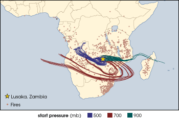
For now, Thompson’s measurements of ozone will be used as part of a program to track low-level ozone from space. During the Lusaka campaign, NASA’s Total Ozone Mapping Spectrometer (TOMS) satellite was also measuring ozone. By comparing the balloon data taken in hazy conditions to satellite data, scientists hope to create new algorithms for extracting tropospheric ozone data from space measurements — a difficult task when one considers the overall thickness of the atmosphere. This information will be useful in coming years as more advanced ozone detectors, such as those aboard NASA’s Aura spacecraft, are launched. “In the end our efforts could help scientists track smog over the entire planet and predict where it is going in the next 24 hours,” says Thompson. | This map shows traces of air moving from locations around Africa until they arrive over Lusaka, indicated by the yellow star. Computer models calculated the trajectories for the first week of September 2000. Higher pressures correspond to lower altitudes. Light red dots correspond to the locations of fires during September of 2000. Pollution from these fires is concentrated around Lusaka. (Map courtesy Anne Thompson, NASA GSFC) |