 |

Cynthia Rosenzweig, a researcher at NASA's Goddard Institute for Space Studies, is a member of the Metropolitan East Coast regional study, which is made up of the 31-county region that comprises the New York City metropolitan area. “We are looking at how people, places, and decision mechanisms of the city respond to climate change and variability as well as to each other,” says Rosenzweig. Her team examined urbanization with city planners, the affects of climate change on human health with the New York City Department of Health, sea level rise with the U.S. Army Corps of Engineers, and wetlands with local environmental groups.
Climate researchers work closely with city planners in New York City to investigate the influence of the “urban heat island” effect on the city, which occurs because asphalt and concrete absorb and retain more heat than vegetation, causing cities to be warmer than surrounding areas. Using satellite data, scientists measure the temperature of the city and can, for example, indicate to city planners where construction of a new park or preserving a forest area would help to cool parts of the city.
|
|
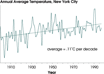
Temperatures in New York City have been climbing for at least a century. Although some of this increase was due to the “heat island” effect, global warming has also contributed to the rise in temperature. (Graph based on data from the Goddard Institute for Space Studies) |
 |

As another example, the results of scientific studies indicate that as the city’s surface temperature rises, there will be an increase in levels of smog, which can lead to public health and environmental concerns. Researchers have found that the impact of ground-level ozone are likely to become an increasing concern over the coming decades. By evaluating the current state of the atmosphere, the team can make better predictions about how future air quality will affect respiratory health and governments can take actions to help limit pollution, according to Rosenzweig.
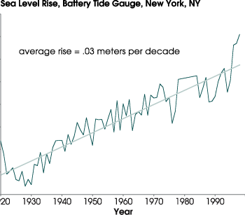
Climate change can also affect coastal regions. Sea-level has risen in the New York areas by between 9 and 15 inches over the last 100 years over the region. This observed rise is likely due to both glacial retreat and the warming trend during the 20th century. As sea level continues to rise, there is an increasing threat of more damaging storm surges and an increase in the frequency of 100-year flood events, which could be occurring as often as every 4 years by the year 2080 if projections are correct. The U.S. Army Corps of Engineers in conjunction with hydrologists and oceanographers annually estimate future beach erosion rates due to sea-level rise. Rates of beach erosion are expected to double or even triple in the region by the 2020s. This information is used to predict the effects of coastal storms. The Corps' annual estimates help hydrologists plan effective strategies to try to protect the shore and property. Hydrologists are also concerned that rising sea-levels will raise the salt level, which would cause problems for wildlife and some well-based water systems.
|
|
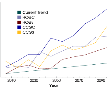
Climate models forecast greater warming for New York than that predicted by simply extending the current temperature trend into the future. The four models shown here are: the Hadley Centre with forcing from greenhouse gases added (HCGG), Hadley Centre model with forcing from greenhouse gases and sulfate aerosols (HCGS), the Canadian Centre for Climate Modeling and Analysis with forcing from greenhouse gases (CCGG), and the Canadian Centre for Climate Modeling and Analysis with forcing from greenhouse gases and aerosols (CCGS). In these models, aerosols slow warming. (Graph based on data from the Goddard Institute for Space Studies) |
 |

Sea-level rise associated with global climate changes not only brings a significant risk to the coast, but also to the coastal wetlands in the region. By analyzing aerial photography and satellite images, researchers can reconstruct how New York's coastal wetlands have evolved over the past 20 years. This information can help scientists predict whether wetland areas will grow or shrink due to climate changes and help local government planners develop policies and preservation practices to protect New York's wetlands.
Based on the research done to contribute to the National Assessment, Rosenzweig says that city agencies will begin to have the information needed to make better decisions that can help limit future problems affecting public health, coastal erosion, water supply and coastal wetlands.
 Surge of the leafy spurge Surge of the leafy spurge
 Adapting to Global Climate Change Adapting to Global Climate Change
|
|
Sea level rise is one of the greatest threats of global warming. In New York, the Battery tide gauge measured an increase in sea level of roughly .25 meters since 1920. (Graph based on data from the Goddard Institute for Space Studies) |

