Making a living in the Ferlo region of northern Senegal is a constant challenge. With a long dry season and little land suitable for crops, many of its people migrate with seasonal rains as they tend small herds of cattle, donkeys, and goats.
Keeping livestock healthy during the long “lean season”—which typically reaches its height between May and July when rains slow and most watering holes dry up—is particularly difficult. Many herding families move frequently, often every few weeks, to find water.
“Inadequate rainfall puts nomadic herders in a particularly perilous position,” said Rebekke Muench, a scientist at the NASA SERVIR Science Coordination Office. SERVIR is a joint initiative of NASA and the U.S. Agency for International Development (USAID).
When rains are inadequate, the consequences can be grave. Lack of suitable forage forces herding families to buy expensive feed to prevent their livestock from starving. Animals end up crowded around just a few popular watering holes, which can easily become hotspots for the spread of viral and bacterial diseases, including foot-and-mouth. The constant walking and the lack of food can easily drive animals and people to exhaustion.
“There is nothing more heartbreaking than hearing stories of people who spend days traveling through treacherous terrain to reach a trusted watering hole only to find that it has dried up," said Muench. “But this happens all the time.”
NASA and USAID researchers have developed a web-based tool to help Senegalese pastoralists get through the lean season. The dashboard features a near-real-time water monitoring system based on satellite observations. The system, now being tested and scheduled for release in August 2020, will make it possible for herders to quickly check how much water remains in hundreds of different watering holes in the Ferlo region before venturing to them.
If people have access to the internet, they will be able to log in to the system directly. For those without internet access, aid organizations in the area plan to send updates about the status of key watering holes via text messages and community radio announcements.
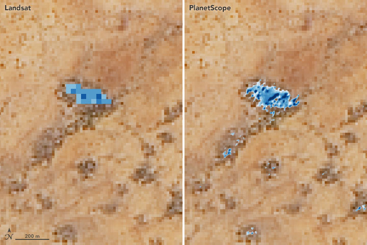
The SERVIR team began working on the project in 2017 using freely available data from Landsat 8 and ESA's Sentinel-2. More recently, they have assessed more detailed PlanetScope data from Planet Labs, a commercial satellite company. After analyzing images of hundreds of watering holes throughout 2018, it became clear that Planet Labs observations improved the accuracy of the tool, explained SERVIR scientist Vikalp Mishra.
“There were even some very small watering holes that we could only monitor with high-resolution imagery. Planet Labs has so many operating satellites in its fleet, we were able to get new images of northern Senegal on a near-daily basis.” he said. “Landsat, due to its long history and superior radiometric quality, still offers a critically important perspective because it has observations that show how key watering holes have fared over decades, a perspective you cannot get from any other satellite.”
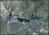
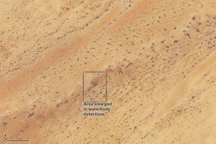
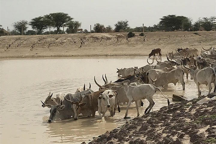
The Landsat image at the top of this page shows how difficult it can be to distinguish between watering holes and bare ground in natural-color satellite imagery. Researchers use an image-analysis technique that makes use of near-infrared observations, which are particularly useful for distinguishing between dry and wet surfaces because water strongly absorbs near-infrared light. The data visualization above shows how Landsat 8 (left) and PlanetScope (right) infrared observations allow researchers to find water that is otherwise hard to spot. The photograph below shows cattle drinking from a watering hole in the Ferlo Valley near the town of Linguère.
The use of high-resolution imagery is part of a pilot program to evaluate whether commercial small-satellite constellations could supplement Earth observations from NASA’s fleet of satellites. “Our study shows that the commercial data would complement the Landsat-based system and has potential to improve our water-monitoring tool and help pastoralists in Senegal,” said Mishra. “But commercial data is not free in the long-term, so we are exploring ways in which we can use it on a sustained basis.”
The new tool will arrive in a period that has been particularly challenging for herding communities in Senegal. Following a year of sparse and erratic rains in 2019, people then had to cope with public health restrictions related to the spread of COVID-19 in 2020. In some parts of the country, the pandemic has even prevented some herding families from moving as they normally would, making it difficult to get their animals to market.
NASA Earth Observatory images by Joshua Stevens, using data courtesy of Vikalp Mishra/NASA Marshall Space Flight Center and Planet Labs, and Landsat data from the U.S. Geological Survey. The SERVIR Global team working on this project includes people from NASA, Agro-Meteorology, Hydrology, and Meteorology (AGRHYMET), Veterinarians without Borders, and the Centre de Suivi Ecologique (CSE). Story by Adam Voiland.