
This image provides a good bird’s-eye view of the center of the city, including famous colonial and independence locations extending from Boston Common to the North End.
Published Nov 17, 2003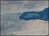
Dividing up water resources in southern California is always a controversial activity. Water allocations for the agriculture in the Imperial Valley, the Salton Sea, and the expanding urban and residential growth in San Diego County were in limbo until a recent agreement was drafted, allowing San Diego to buy conserved Colorado River water from the Imperial Valley. This astronaut photograph details an algal bloom in the Salton Sea, where such blooms continue to be a problem. They are caused by high concentrations of nutrients, especially nitrogen and phosphorous, that drain into the basin from the agricultural run-off. As the algae dies and decomposes, oxygen levels in the sea drop, causing fish kills and hazardous conditions for other wildlife.
Published Nov 10, 2003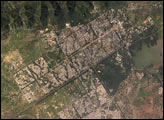
Two capital cities in Pakistan lie next to one another but display land use patterns that are entirely different. Islamabad, with a population of 901,000 (ca. 1998) boasts a master-planned rectangular street pattern nestled against the Margala Hills (top left). The larger Rawalpindi (population 1,406,214 in 1998) lies to the south on the Soan River. Islamabad has grown rapidly since construction began in 1961. It was created as a new administrative district in Pakistan to be the home of government, the supreme court, and the diplomatic corps. The great white building of the Faisal Mosque appears on the northern margin of the city. By contrast with orthogonal Islamabad, Rawalpindi displays the radial land transportation pattern of many cities with a river flowing through the city center. City blocks are small and growth less controlled than in its newer neighbor.
Published Nov 3, 2003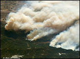
Fires in the San Bernadino Mountains, driven by Santa Ana winds, burned out of control Sunday morning when these images were taken from the International Space Station (ISS) at roughly 11 a.m. PST. Thick yellow smoke blows south, blanketing the valley below. This photgraph, looking southeast, captures the smoke pall as the ISS approached and passed over the region. Lake Arrowhead is the reservoir near the left edge of the photograph.
Published Oct 27, 2003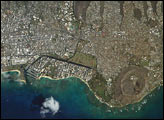
As the Expedition 7 crew on the International Space Station was set to come home to Earth, crew member Ed Lu was inspired to photograph his hometown, Honolulu, during an overpass. Honolulu is striking for the way it is bound by surrounding geography. Built-up fingers of the city extend northeast onto the steep volcanic slopes and surround the volcanic craters of Punchbowl and Diamond Head, leaving undeveloped only parklands and the steepest ridges. They are both tuff cones that formed as magma from the erupting volcano came in contact with ground water at a time when sea levels were higher than they are now. As the water turned to steam, it caused an explosion that formed a hill of ash with a broad crater in the center.
Published Oct 27, 2003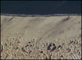
The area shown here (10 kilometers across) is a small part of the dune field which is now protected as the Len&ccelde;óis Maranhenses National Park, on Brazil’s north coast, about 700 kilometers east of the Amazon River mouth. Persistent winds blow off the equatorial Atlantic Ocean onto Brazil from the east, driving white sand inland from the 100 kilometer stretch of coast (upper margin of the image), to form a large field of dunes. The strongly regular pattern of these dunes is a common characteristic of dune fields. The basic shape of each sand mass, repeated throughout the view, is a crescent-shaped dune. In an area with a rich supply of sand such as coastal Brazil, individual crescents coalesce to form entire chains many miles long. The wind strength and supply of sand are sufficient to keep the dunes active, and thus free of vegetation, despite 1500 mm (60 inches) of rainfall annually. The dark areas between the white dunes are fresh water ponds that draw fisherman to this newly established park.
Published Oct 20, 2003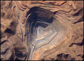
The rugged, mineral-rich Andes support some of the world’s biggest mines (gold, silver, copper, and more). This image looks down the bullseye of Peru’s Toquepala copper mine, a steep sided and stepped open-pit mine.
Published Oct 13, 2003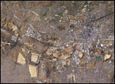
The center of Johannesburg is the fine-grained pattern (created by shadows cast from the high rise buildings in the city) in the center of this mosaic. On the southern fringe of Johannesburg is a line of light colored, angular patches stretching across the scene. These patches are the great “mine dumps,” the crushed rock that remains after gold extraction from numerous gold mines.
Published Oct 6, 2003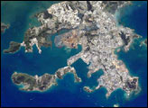
New Caledonia represents a nexus of cultures and resources. At its center is Grande Terre, the third largest island in the Pacific. The indigenous population is Melanesian, with a Polynesian minority, but New Caledonia remains a French territory. A prime tourist destination, the island supports the second largest barrier reef in the world (over 1300 kilometers long) with one of the highest levels of biodiversity. This astronaut photograph shows details of New Caledonia’s main city, Noumea, which is built on a peninsula that juts into the lagoon on the southwest side of the island. The reefs here face localized problems from pollution and overfishing. The picture also shows how urban development extends to the steep slopes of the coastal hills.
Published Sep 29, 2003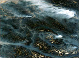
This image taken by the crew of the International Space Station on August 20, 2003, illustrates how smoke has become trapped in valleys. Normally air temperature decreases with altitude; in other words, the higher up you are, the colder it is. Warmer, more buoyant air near the surface of the Earth usually rises into the atmosphere, carrying away air pollutants such as smoke. However, sometimes the “higher equals colder” relationship breaks down, for example, here in the northern Rockies, where light winds and cold air drainage from the higher elevations have created “temperature inversions,” making the air in the valley colder and denser than the air at the mountain peaks.
Published Sep 24, 2003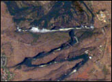
Victoria Falls, on the Zambezi River, is one of the most famous tourist sites in subsaharan Africa. Details of the Falls are visible in this image taken with the 800 mm lens by Astronaut Edward Lu from the Space Station on September 4, 2003. The positions of the falls are controlled by linear fault lines in the underlying basalt rocks. The falls have moved upstream (bottom to top) by intense river erosion, elongating the zig-zag gorge in the process. Prior positions of the strongly linear falls can be detected. The earliest on this cropped view may have been the longest (dashed line). The zig-zags represent subsequent positions, all with the characteristic water-worn lip on the upstream side. The falls will continue to erode northward.
Published Sep 22, 2003
From his vantage point high above the earth in the International Space Station, Astronaut Ed Lu captured this broad view of Hurricane Isabel.
Published Sep 16, 2003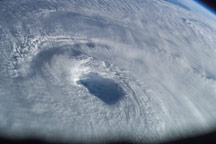
Astronaut Ed Lu captured this image of the eye of Hurricane Isabel as he passed overhead in the International Space Station on September 15, 2003. The storm had weakened somewhat, but still maintained its status as a Category 4 hurricane.
Published Sep 16, 2003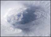
Astronaut Ed Lu snapped this photo of the eye of Hurricane Isabel from the International Space Station on September 13, 2003 at 11:18 UTC. At the time, Isabel was located about 450 miles northeast of Puerto Rico. It had dropped to a Category 4 hurricane on the Saffir-Simpson Hurricane Scale, packing winds of 150 miles per hour with gusts up to 184 miles per hour. This photo reveals the structure of Isabel’s eyewall.
Published Sep 16, 2003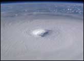
Astronaut Ed Lu captured this broad-view photograph of Hurricane Isabel from the International Space Station on September 13, 2003. At the time, Isabel was located about 450 miles northeast of Puerto Rico and packed winds of 150 miles per hour with gusts up to 184 miles per hour.
Published Sep 15, 2003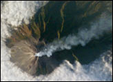
At 2,911 meters, the summit of Merapi Volcano and its vigorous steam plume rises above a bank of stratus clouds on its southern flank on August 24, 2003. One of Indonesia’s most active volcanoes, it has been almost continuously active for nearly ten years, including periodic pyroclastic flows (hot ash and rock debris) and avalanches. The volcano is located less than 25 miles north of the city of Yogykarta in central Java. More than 50,000 people live adjacent the treacherous southwestern slope, where volcanic material often sloughs from the unstable summit. Note the deep ravines on the eastern slopes providing rich soils and moisture to the agriculture below.
Published Sep 15, 2003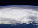
Astronauts on board the International Space Station photographed Hurricane Fabian on September 4, 2003 as it churned towards Bermuda. At the time the photo was taken, Fabian had maximum sustained winds of 120 mph and was moving to the north-northwest at 12 mph.
Published Sep 8, 2003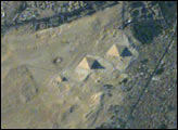
All astronauts are interested in observing unique human footprints from space, and especially those reflecting thousands of years of human activities. The region of the Great Pyramids of Giza—the last remaining wonder of the Seven Wonders of the Ancient World—is a favorite target. Although the pyramids have been imaged many times before by astronauts, each new image provides a unique look at the archeological monument, depending on the viewing angle from the ISS and the illumination from the sun. In this view, the shadows from afternoon sun provide directional arrows that point east. For scale, the current length of the large pyramid at the base is 227 meters (745 feet), and the height is 137 meters (449 feet).
Published Sep 7, 2003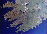
This broad view from the International Space Station shows the relationship between valleys, mountains, and the major towns. Near Killarney are ancient oak and yew forests.
Published Aug 31, 2003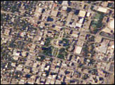
It was Texas hot when this view of the capital city of Austin was taken in late July by astronaut Ed Lu. Adding to the rising temperatures were heated debates in the Texas Capitol Building, where a special session had convened. Eleven senate Democrats thwarted a redistricting vote by disappearing from the state. Were Lu, and his Expedition 7 partner Yuri Malenchenko looking for the missing Democrats? We’ll never know. Astronauts have always enjoyed observing cities around the world. These images of Austin provide a 2003 baseline for monitoring its regional development and growth.
Published Aug 24, 2003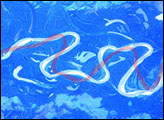
The Mamore River drains north from the Andes Mts. in lowland Bolivia. An image taken in July 2003 from the International Space Station (ISS007-E-10797, 14 June 2003, 12:36 GMT) shows an 85 km stretch of the river south of the lowland town of Trinidad in the Beni Province. Numerous changes in river pattern are visible in the decade since Landsat imagery of the same area was acquired.
Published Aug 18, 2003
An astronaut on the ISS caught a glimpse of a sliver of the setting Moon and some clouds that shine at night.
Published Aug 10, 2003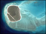
The Îles Eparses (scattered islets) dot the Indian Ocean to the west and north of Madagascar. The islands were protected by the French government in 1975 because of their importance for turtles and seabird nesting. This astronaut photograph, taken on June 17, 2001, from the International Space Station, shows details of the reefs surrounding Îles Glorieuses, one group in the Îles Eparses. The image was used to plan the 2002–03 field expeditions conducted by Agence pour la Recherche et la Valorisation Marines.
Published Aug 3, 2003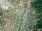
This regional view of Salt Lake City, photographed on 14 June 2003 from the International Space Station, shows the city and its suburbs nestled between the Wasatch Front and the Great Salt Lake.
Published Jul 27, 2003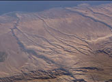
Some of the deepest canyons in the world cut west to the Pacific from the high crest of the Andes Mountains in Peru. This dramatic image taken from the International Space Station provides a birds-eye view down the canyons of the Rio Camana and the Rio Ocona. The low early morning sun highlights the extreme topography created by rapidly uplifting mountains and powerful water erosion by water dropping nearly 10,000 feet (more than 3000 m) in this view. At the edge of the image is the snowy flanks of Nevado Coropuna, the highest mountain in the Cordillera Occidental (6613 meters).
Published Jul 20, 2003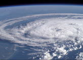
The crew of the International Space Station had a great seat from which to observe tropical storm Claudette as it became a Category I hurricane. The storm came ashore with high winds up to 80 miles per hour and heavy rains that also drenched their Houston home base and the Coastal Bend of Texas.
Published Jul 18, 2003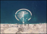
The Islands were constructed on reclaimed land off of Dubai’s Persian Gulf coast.
Published Jul 13, 2003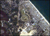
In 2003 the world celebrated a century of human flight with the one hundredth anniversary of the Wright Brothers’ first flight at Kitty Hawk, North Carolina. Astronauts aboard the International Space Station share a kindred spirit of flight accomplishments and commemorated the centennial celebration with this image of Kitty Hawk and the Wright Brothers National Memorial. Kitty Hawk is located on North Carolina’s Outer Banks. The Wrights used the Outer Banks’ prevailing winds and the altitude gained by climbing a 90-foot hill (Kill Devil Hill) to successfully demonstrate powered flight. The large circle on the image is a road ringing Kill Devil Hill, now part of the Wright Brothers National Memorial.
Published Jul 6, 2003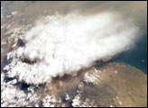
Which came first, the clouds or the dust? Both clouds and dust can be important factors influencing regional climate, and they are frequently observed together. In this view taken from the International Space Station, two images were merged to create a mosaic of a dust storm and thunderstorm over the Red Sea. By interpreting the mosaic, we make a guess about which came first.
Published Jun 29, 2003
City lights define the Nile River Valley as it snakes across the Egyptian desert. The cities of Naj’ Hamadi, Qena, and Luxor, shine the brightest. Communities in the hillsides create a thin border along either side of the valley. Simliar strips line the Nile itself. Most of Egypt’s population, and most of the country’s arable land, occupies the Nile River Valley.
Published Jun 25, 2003