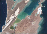
Lago de Valencia (Lake Valencia) is located in north-central Venezuela and is the largest freshwater lake in the country. The lake was formed approximately 2-3 million years ago due to faulting and subsequent damming of the Valencia River. The lake has been completely dry during several discrete periods of its geologic history. Since 1976 Lake Valencia water levels have risen due to diversion of water from neighboring watersheds—it currently acts as a reservoir for the surrounding urban centers (such as Maracay).
Published Nov 22, 2004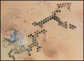
Green circles in the desert frequently indicate tracts of agriculture supported by center-pivot irrigation. The Al Khufrah Oasis in southeastern Libya (near the Egyptian border) is one of Libya’s largest agricultural projects, and is an easy-to-recognize landmark for orbiting astronauts aboard the International Space Station. Because only about 2 percent of Libya’s land receives enough rainfall to be cultivated, this project uses fossil water from a large underground aquifer. The Libyan government also has a plan called the Great Man Made River to pump and transport these groundwater reserves to the coast to support Libya’s growing population and industrial development.
Published Nov 15, 2004
Corrientes, Argentina (sits on the east bank of the Paraná River, South America’s third largest river. Corrientes is located just inside Argentina, across the river from the southwestern tip of Paraguay.
Published Nov 8, 2004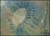
Gebel (or Mount) Edmonstone is a flat-topped mesa located near the Dahkla Oasis south of Cairo, Egypt. The Oasis is a historically important meeting place of several trade routes connecting different regions of Egypt and Sudan. Gebel Edmonstone is a remnant of an eroding scarp that extends for over 200 kilometers (125 miles) east-southeast to west-northwest (visible in the upper left corner of the image). The flat caprock of both the scarp and Mount Edmonstone is chalky limestone underlain by fossil-bearing shale and fine-grained sedimentary rocks.
Published Nov 1, 2004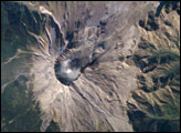
Early in October 2004 Mt. St. Helens rumbled back to life with earthquakes, minor eruptions of steam and ash, and renewed growth of the summit lava dome. Fortuitous trajectories of the International Space Station provided the ISS crew excellent views of the area.
Published Oct 25, 2004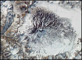
The high peaks of the Andes form the backbone of South America and the political border between Chile and Argentina. Formed from the subduction of the Nazca Plate under the South American Plate, the south-central Andes also includes several major volcanoes. One of the most active border volcanoes is Volcan Maipo, located just southeast of Santiago, Chile. This image from the International Space Station shows the volcano near the southern hemisphere spring equinox. The lake, just east of Maipo’s peak, is still ice-covered. However, the increasing temperatures of spring are suggested by a muddy-looking streak near the lower left corner. The streak appears to be a landslide or avalanche that flowed westward down a rugged slope, possibly triggered by instability in the snowpack due to snow melt.
Published Oct 18, 2004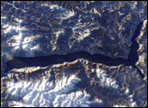
Lake Teletskoye, one of Siberia’s prime tourist destinations, is a large lake that is nestled in a narrow valley between the snow-capped Al-tyntu (west, at top) and Korbu (east, at bottom) mountain ridges of the Altai Mountains. The lake is nearly 80 kilometers long by 5 kilometers wide and 325 meters deep; it is one of the deepest lakes in the world. But Lake Teletskoye is more than a large, deep lake. It is located within the 9,000 km² Altaisky Zapovednik nature reserve, which helps protect its unspoiled waters.
Published Oct 11, 2004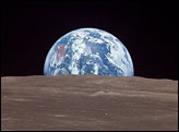
Over the stark, scarred surface of the moon, the Earth floats in the void of space, a watery jewel swathed in ribbons of clouds.
Published Oct 4, 2004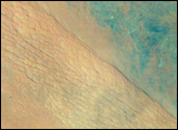
Astronauts have obtained thousands of detailed images of the world’s remote deserts, helping scientists better understand local geomorphological features in a regional context. Driven by northwesterly winds, sands from northwest Saudi Arabia have accumulated in the center of the country as great rivers of dunes (cordons) that extend for hundreds of kilometers. About 320 kilometers northwest of Riyadh, the steep, almost cliff-like margin of the Ad Dahna cordon casts a shadow (right center; diagonally across the scene). Two types of dune surface appear: the tracery of numerous linear dunes (center) and a featureless sand sheet (lower left). Dark, older rocks (30-65 million years old—top right) underlie the sand sea and crop out northeast of the cordon. Convergent dry river beds appear top right.
Published Sep 27, 2004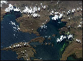
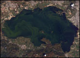
At an average elevation of 3,812 meters (12,507 feet), Lake Titicaca is one of the highest lakes in the world. The lake is positioned between two major ranges of the Andes Mountain chain and has very limited drainage. The limited outflow of the lake allows for the accumulation of nutrients derived primarily from surrounding communities’ agricultural and sewage waste. The increased nutrient levels can lead to plankton blooms. This astronaut photograph, taken from the International Space Station, captures two such blooms along the eastern shoreline of the lake.
Published Sep 20, 2004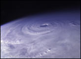
This photo of Hurricane Ivan was snapped as the International Space Station passed over the eye of the storm on Saturday, September 11, 2004, about 15 minutes after 23:00 GMT (7 p.m. EDT). At the time, Ivan was wobbling west off its predicted course, its eye just missing Jamaica. The storm was a powerful and dangerous Category 5 storm with sustained winds reaching to 270 kilometers per hour (165 mph) and higher gusts.
Published Sep 13, 2004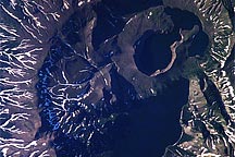
Some of the world’s most active volcanoes make up the spine of the Kamchatka Peninsula in far east Russia. Kamchatka is the northwestern edge of the Pacific “ring of fire,” where earthquakes and volcanism are caused by ongoing subduction of the Pacific oceanic plate beneath the Eurasian plate. This astronaut photograph profiles the summit area of Ksudach Volcano, also called Voniuchi Khrebet Volcano, in southern Kamchatka. White snow on the ridges in this image contrasts with the dark volcanic soils and highlights the well-developed radial drainage pattern down the slopes of the volcano.
Published Sep 13, 2004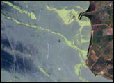
Venezuela’s Lake Maracaibo presents a complicated surface to interpret. Oil platforms and other infrastructure supporting the oil industry generate oil slicks, heavy ship traffic produces linear ship wakes, and vivid green streaks and swirls are patches of duck weed growth that has thrived on the lake.
Published Sep 6, 2004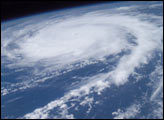
This photo of Hurricane Frances was taken by Astronaut Mike Fincke aboard the International Space Station as he flew 230 statute miles above the storm at about 9 a.m. CDT Friday, Aug. 27, 2004.
Published Aug 30, 2004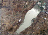
Astronauts aboard the Space Shuttle and Space Station have tracked regional environmental changes spanning decades. Lake Chapala, Mexico’s largest lake, serves as one example of an area experiencing significant changes that have been well documented from space. Over the past twenty years, the lake’s water levels have decreased in conjunction with increasing development from the fast-growing city of Guadalajara.
Published Aug 30, 2004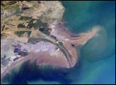
The Yellow River Delta coastline along the Gulf of Bohai has always experienced dramatic changes, and those changes continue today. This mosaic of images taken by astronauts aboard the International Space Station shows several things. First, the image shows today’s configuration of the delta of China’s Yellow River, which is one of the most dynamic coastlines on Earth. Second, the scene allows mapping of land use along the coastal plain, including the boundaries of the Shengli Oil Field, China’s second largest oil field. But perhaps the most interesting aspect of this image is the large patch of green water off the northern coast of the delta—a presumed plankton bloom.
Published Aug 23, 2004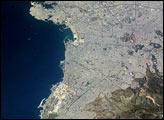
Athens, Greece, enjoys both historical and current significance on the world stage. The ancient city of Athens, considered to be the birthplace of many Western traditions in philosophy, the arts, and the scientific method, is located in the Central Plains region of Attica in eastern Greece. This astronaut photograph captures the western extent of the modern urban area.
Published Aug 16, 2004
The Dominican Republic occupies the eastern two-thirds of the island of Hispaniola in the Caribbean Sea. The island has a variety of ecosystems ranging from arid plains to tropical rain forests created by three roughly parallel east-west mountain ranges. The northernmost of these ranges, the Cordillera Septentrional, is visible in this astronaut photograph as the dark green region north of the river. Clearcut regions within the Cordillera Septentrional are visible as irregular light green regions interspersed with dark green forested areas.
Published Aug 9, 2004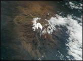
Most scientists agree that the glaciers of Mt. Kilimanjaro will be gone by the year 2020, but there is less agreement as to why they are now receding.
Published Aug 2, 2004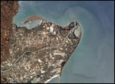
The Ebro River Delta, located along the eastern coast of Spain, is one of the largest wetland areas in the western Mediterranean region.
Published Jul 26, 2004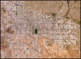
Tucson lies between the forested Catalina Mountains and the Tucson Mountains (dark reddish brown at the left image margin).The typical western North American cityscape is a pattern of regular north-south aligned rectangles outlined by major streets set one mile apart.
Published Jul 19, 2004
Located on the highly populated Hawaiian island of Oahu just west of Honolulu, Pearl Harbor is the historic center of events on “the day that will live in infamy”—December 7, 1941—when the Japanese fleet launched a surprise air attack on Pearl Harbor and other strategic military targets on Oahu. The ISS-6 Space Station crew obtained this high-resolution image of Pearl Harbor in March 2003, enabling detailed observations of the harbor and its multiple uses.
Published Jul 12, 2004
The roofs of Barcelona’s buildings appear as a widespread pink swath on the Mediterranean coastal plain, between forested hills (dark green, top) and the sea. The Llobregat River enters the view top center, cuts through a canyon in the hills and historically constructed a broad, convex delta south of the forested hills. Channelization of the Llobregat River to control flooding has encouraged development of the delta for a variety of urban and agricultural land uses. Barcelona’s airport is located in the central portion of the delta, while the western portion is used for intensive agriculture (light green areas).
Published Jul 5, 2004
The Colorado River is the largest watershed in the southwestern US, emptying into the Salton Trough before reaching the Sea of Cortez. Over the past 2-3 million years, river sediments built a delta that extends from the US-Mexico border for a distance of 87 miles (140 kilometers). However, today the Colorado River delta is undergoing significant erosion and diminishing in size due to the lack of sediment replenishment from upstream sources.
Published Jun 28, 2004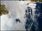
Surf’s up! This image is a mosaic of two photographs taken by astronauts aboard the International Space Station viewing large internal waves in the Strait of Gibraltar. These subsurface internal waves occur at depths of about 100 m, but appear in the sunglint as giant swells flowing eastward into the Mediterranean Sea. The narrow Strait of Gibraltar is the gatekeeper for water exchange between the Atlantic Ocean and Mediterranean Sea. A top layer of warm, relatively fresh water from the Atlantic Ocean flows eastward into the Mediterranean Sea. In return, a lower, colder, saltier layer of water flows westward into the North Atlantic ocean. A density boundary separates the layers at about 100 m depth.
Published Jun 21, 2004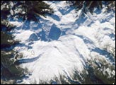
The Cascade Range is an arc of volcanoes that extends from southwestern British Columbia to northern California. One of the six major composite volcanoes (formed by alternating layers of extruded lava and compacted ash) is Mount Baker in northern Washington.
Published Jun 14, 2004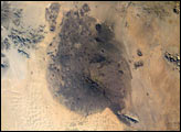
The Pinacates region of Mexico’s Sonoran Desert is one of the most unique and striking landscapes in North America. Located just a few miles south of the Mexico-Arizona border, this volcanic field originated with the rifting of the Gulf of California millions of years ago, but the features seen today (volcanic peaks, lava flows, cinder cones and collapsed craters) formed in the late Pleistocene period (2 million to 11,000 years ago). The volcanic range is surrounded by one of North America’s largest dune fields, Gran Desierto. Early in May 2004, the new Space Station crew (ISS-9) obtained high-resolution images of the Pinacates, allowing for detailed observations of the surface features. One example is a large volcanic crater (see box, and detail below) called Crater Elegante which is one of the most prominent and interesting features of the Pinacates.
Published Jun 8, 2004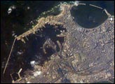
Founded by Alexander the Great in 331 BC on the Mediterranean coast of Egypt, Alexandria became a center of trade and learning in the ancient world. he Eastern Harbor was the main port in the Middle Ages. This detailed image taken by Space Station crew members using an 800-mm lens provides a view of the modern port facilities in the Western Harbor, where wharves and many moored ships can be detected.
Published May 31, 2004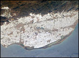
The sunny south of Spain offers more to the national economy than simply tourism. Over the past 50 years, the small coastal plain (campo), some 30 kilometers southwest of the city of Almería, has been intensively developed for agriculture. An estimated 20,000 hecatres of extra-early market produce is grown in greenhouses in the Campo de Dalías.
Published May 24, 2004