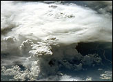
This photograph, acquired in February 1984 by an astronaut aboard the space shuttle, shows a series of mature thunderstorms located near the Paraná River in southern Brazil. With abundant warm temperatures and moisture-laden air in this part of Brazil, large thunderstorms are commonplace. A NASA-funded researcher has discovered that tiny airborne particles of pollution may modify developing thunderclouds by increasing the quantity and reducing the size of the ice crystals within them. These modifications may affect the clouds’ impact on the Earth’s “radiation budget,” or the amount of radiation that enters and leaves our planet.
Published May 15, 2002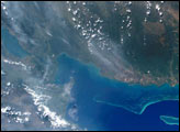
The bright blue water of the Gulf of Honduras contrasts sharply with the smokey pall over Guatemala and Belize in this photograph taken from the International Space Station. Fires in the Yucatan Penninsula and northern Central America began burning in early April, and intensified by the end of the month.
Published May 14, 2002
The colors of the agricultural fields surrounding Paris are striking in thespringtime, even when viewed from a 400-kilometer orbital altitude, as seen in this photography taken by astronauts on board the International Space Station.
Published May 12, 2002
Astronaut photography of the Earth from the International Space Station has achieved resolutions close to those available from commercial remote sensing satellites—with many photographs having spatial resolutions of less than six meters. Astronauts take the photographs by hand and physically compensate for the motion of the spacecraft relative to the Earth while the images are being acquired.
Published May 6, 2002
This detailed image of Everest, the highest (29,035 feet, 8850 meters) mountain in the world, shows early morning light on the eastern Kangshung Face. The mountains appear to jump out of the picture because the image was taken with low sunlight using an electronic still camera equipped with an 800 mm lens.
Published Apr 28, 2002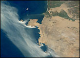
Coastal fog commonly drapes the Peruvian coast. This image captures complex interactions between land, sea, and atmosphere along the southern Peruvian coast. When Shuttle astronauts took the image in March 2002, the layers of coastal fog and stratus were being progressively scoured away by brisk south to southeast winds.
Published Apr 21, 2002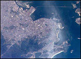
A dengue fever outbreak has plagued Rio de Janeiro since January 2002. Dengue fever is a mosquito-borne disease. The elimination of standing water, which is a breeding ground for the mosquitoes, is a primary defense against mosquito-borne diseases like dengue. Removing such water remains a difficult problem in many urban regions.
Published Apr 14, 2002
International Space Station crew members are regularly alerted to dynamic events on the Earth’s surface. On request from scientists on the ground, the ISS crew observed and recorded volcanic activity from the summit of Soufriere Hills on March 20, 2002.
Published Apr 7, 2002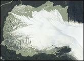
The San Quintín Glacier is the largest outflow glacier of the Northern Patagonian Ice Field in southern Chile. Like many glaciers worldwide during the twentieth century, San Quintín appears to be losing mass and possibly retreating.
Published Mar 31, 2002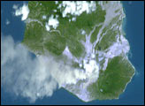
An Earth Observatory reader used widely available software to correct the oblique perspective of an earlier photograph of Montserrat and to adjust the color. The story of how he modified the image includes step-by-step instructions that can be applied to other photographs.
Published Mar 27, 2002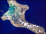
Pronounced “Ki-ris-mas,” Kiritimati Island has a large in-filled lagoon that gives it the largest land area (125 square miles, 321 square kilometers) of any atoll in the world. Captain Cook named the atoll Christmas Island when he arrived on Christmas Eve in 1777. Used for nuclear testing in the 1950s and 1960s, the island is now valued for its marine and wildlife resources. It is particularly important as a seabird nesting site—with an estimated 6 million birds using or breeding on the island, including several million Sooty Terns. Rainfall on Kiritimati is linked to El Ni&ntidle;o patterns, with long droughts experienced between the wetter El Ni&ntidle;o years.
Published Mar 24, 2002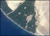
A tsunami washed over the low-lying coastal resort region near Camaná,southern Peru, following a strong earthquake on June 23, 2001. The earthquake was one of the most powerful of the last 35 years and had a magnitude of 8.4. After the initial quake, coastal residents witnessed a sudden draw-down of the ocean and knew a tsunami was imminent. They had less than 20 minutes to reach higher ground before the tsunami hit. Waves as high as 8 meters came in four destructive surges reaching as far as 1.2 kilometers inland. Thousands of buildings were destroyed, and the combined earthquake and tsunami killed as many as 139 people.
Published Mar 17, 2002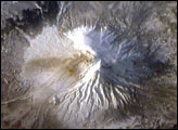
Shiveluch volcano anchors the northern end of a volcanic chain of more than 100 volcanoes covering the Kamchatkan Peninsula. It is one of the most active volcanoes along the Pacific Rim. In 2001, astronauts aboard the International Space Station Alpha looked north toward Shiveluch’s scarred southern slope to get a unique perspective of the impressive cluster of volcanoes in the Klyuchevskaya group and Shiveluch.
Published Mar 10, 2002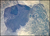
The Al Hawizah Marshes comprise the largest remaining tract of wetlands in the Mesopotamian Marshlands of Iran and Iraq. In the last 10 years, damming and diversion of waters from the Tigris and Euphrates Rivers, and draining of wetlands has led to a loss of 85% of wetlands that once covered about 20,000 square km (7,725 square miles).
Published Mar 3, 2002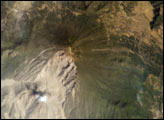
The eruption of Santa Maria volcano in 1902 was one of the largest eruptions of the 20th century, forming a large crater on the mountain’s southwest flank. Since 1922, a lava-dome complex, Santiaguito, has been forming in the 1902 crater. Growth of the dome has produced pyroclastic flows as recently as the 2001—they can be identified in this image. The volcano is considered dangerous because of the possibility of a dome collapse such as one that occurred in 1929, which killed about 5000 people. A second hazard results from the flow of volcanic debris into rivers south of Santiaguito, which can lead tocatastrophic flooding and mud flows.
Published Feb 24, 2002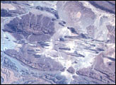
The Anti-Atlas Mountains of northern Africa and the nearby Atlas mountains were created by the prolonged collision of the African and Eurasian tectonic plates, beginning about 80 million years ago.
Published Feb 10, 2002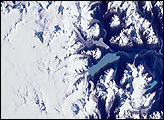
The Northern Patagonian Ice Field (NPIF), centered near 47°S, 73.5°W, is the smaller of two remnant ice masses crowning the Andes Mountains of lower South America. The NPIF is a vestige of an extensive ice sheet that covered much of Patagonia just over a million years ago. Today, with its glaciers largely in retreat and only an area of 4,200 sq km, it is still the largest continuous mass of ice outside of the polar regions.
Published Feb 2, 2002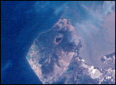
For decades, astronauts on space missions have documented land use changes around the world. Here, astronauts track the development of shrimp farming along the Honduran coastline of the Gulf of Fonseca between 1989 and 2001.
Published Jan 27, 2002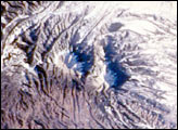
The Spanish Peaks, on the eastern flank of the Sangre de Cristo range in Colorado, abruptly rise 7,000 feet above the western Great Plains. Settlers, treasure hunters, trappers, gold and silver miners have long sighted on these prominent landmarks along the Taos branch of the Santa Fe trail. Well before the westward migration, the mountains figured in the legends and history of the Ute, Apache, Comanche, and earlier tribes. “Las Cumbres Espa&ntidle;olas” are also mentioned in chronicles of exploration by Spaniards including Ulibarri in 1706 and later by de Anza, who eventually founded San Francisco, California. This exceptional view, captured by the crew of Space Shuttle mission STS108, portrays the Spanish Peaks in the context of the southern Rocky Mountains.
Published Jan 20, 2002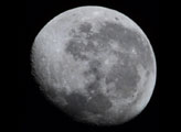
Inspired by the nearly-full moon, space station astronauts used an 800 mm lens to study the craters and mare. This view, taken October 5, 2001, is centered on Crater Copernicus, surrounded by the Mare Serenitatis and Mare Tranquillitatis (Sea of Serenity and Sea of Tranquility), Mare Imbrium (Sea of Rains), Oceanus Procellarum (Ocean of Storms) and Mare Nubium (Sea of Clouds). The bright crater and ejecta trails of Tycho dominate this near-side view. For scale, the crater of Tycho is 85 km in diameter.
Published Jan 13, 2002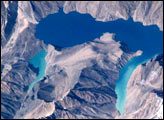
Lake Sarez, deep in the Pamir mountains of Tajikistan, was created 90 years ago when a strong earthquake triggered a massive landslide that, in turn, became a huge dam along the Murghob River, now called the Usoi Dam. The resulting lake is perched above surrounding drainages at an elevation greater than 3000 meters. The lake is 61 kilometers long and as deep as 500 meters, and holds an estimated 17 cubic kilometers of water. The area experiences considerable seismic activity, and scientists fear that part of the right bank may slump into the lake, creating a huge wave that will top over and possibly breach the natural dam. Such a wave would create a catastrophic flood downstream along the Bartang, Panj and Amu Darya Rivers, perhaps reaching all the way to the Aral Sea.
Published Jan 6, 2002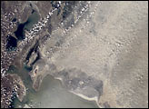
The Aral Sea has shrunk to less than half its size since 1985. It receives little water (sometimes none) from the two major rivers that empty into it—the Syr Darya and Amu Darya. Instead, the river water is diverted to support irrigation for the region’s extensive cotton fields. Recently, water scarcity has increased due to a prolonged drought in Central Asia. As the Aral Sea recedes, its former seabed is exposed. The Aral’s sea bed is composed of fine sediments—including fertilizers and other agricultural chemicals—that are easily picked up by the region’s strong winds, creating thick dust storms. The International Space Station crew observed and recorded a large dust storm blowing eastward from the Aral Sea in late June 2001. This image illustrates the strong coupling between human activities (water diversions and irrigation), and rapidly changing land, sea and atmospheric processes—the winds blow across the Sea and pick up dust (former sea bottom sediments) as soon as the blowing air masses hit land.
Published Dec 30, 2001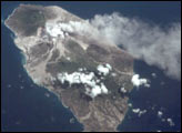
Volcanic activity on the West Indian island of Montserrat has remained high for several years—the current activity started in 1995. However, remote sensing of the island has been difficult because of frequent cloud cover. The International Space Station crew flew north of the island on a clear day in early July (July 9, 2001) and recorded a vigorous steam plume emanating from the summit of Soufriere Hills. The image also reveals the extensive volcanic mud flows (lahars) and new deltas built out from the coast from the large amounts of volcanic debris delivered downstream by the rivers draining the mountain. As a small island (only 13 x 8 km), all of Montserrat has been impacted by the eruptions.
Published Dec 23, 2001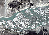
On October 13, 2000, the Expedition 3 crew of the International Space Station, high over Tibet, took this interesting photo of the Brahmaputra River. This mighty Asian river carves a narrow west-east valley betweenthe Tibetan Plateau to the north and the Himalaya Mountains to the south, as it rushes eastward for more than 1500 kilometers in southwestern China. This 15-kilometer stretch is situated about 35 kilometers south of the ancient Tibetan capital of Lhasa where the river flow becomes intricately braided as it works and reworks its way through extensive deposits of erosional material. This pattern is indicative of a combination heavy sediment discharge from tributaries and reduction of the river’s flow from either a change in gradient or perhaps even climate conditions over the watershed.
Published Dec 16, 2001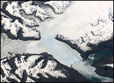
Brüggen Glacier in southern Chile is the largest western outflow from the Southern Patagonian Ice Field and, unlike most glaciers worldwide, advanced significantly since 1945. From 1945 to 1976, Brüggen surged 5 km across the Eyre Fjord, reaching the western shore by 1962 and cutting off Lake Greve from the sea.
Published Dec 9, 2001
Red colors of the aurora are dominant in this image captured by a digital still camera in September 2001. Auroras are caused when high-energy electrons pour down from the Earth’s magnetosphere and collide with atoms. Red aurora occurs from 200 km to as high as 500 km altitude and is caused by the emission of 6300 Angstrom wavelength light from oxygen atoms.
Published Dec 2, 2001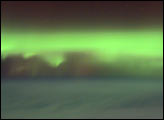
As geomagnetic storms cause beautiful displays of aurora across the United States, astronauts onboard the International Space Station also have the opportunity to take a look. Green colors of the aurora are dominant in this image captured by a digital still camera on October 4, 2001.
Published Nov 11, 2001
For more than 240 million years the region now known as Italy has been the scene of episodic volcanic activity. East-southeast of Napoli (Naples) stands the imposing cone of Vesuvius, which erupted explosively in 79 A.D. to bury Pompeii and Herculaneum.
Published Nov 4, 2001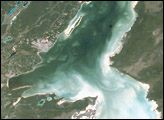
Chetumal Bay lies on the Border between Mexico and Belize. To the east of the bay, Ambergris Cay connects the Belize Barrier Reef to the Yucatan Peninsula. The north of the island is Bacalar Chico Marine Reserve. Here, the barrier reef comes very close to the east side of the island. In 1998, reefs in Belize were hit by two major events that led to heavy coral mortality: El Niño-related coral bleaching and Hurricane Mitch.
Published Oct 28, 2001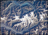
The Bernese Alps form the centerpiece of this late summer view of Switzerland; Jungfrau (4158 m), Moench (4089 m), and Eiger (3970 m) are among the higher peaks of the Central Alps. North of the range is the city of Interlaken, flanked by the Thune See and Brienzer See (lakes); the long, straight-segmented valley of the Rhone lies to the south.
Published Oct 21, 2001