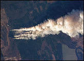
Dry conditions and high winds have lead to numerous recent fire outbreaks throughout much of the southwestern and south-central USA. Drought conditions have persisted in the region for months, leading to a build-up of fire fuels, including dried grasses, shrubs, and trees. The combination of high amounts of dry fuel and frequent high winds has stoked small fires into widespread brush fires. This astronaut photograph captures a 25-kilometer long smoke plume from a fire in the Upper Ouachita National Wildlife Refuge in northeastern Louisiana. The fire started at approximately 1:00 p.m. on January 2, 2006, and this image was acquired approximately three and a half hours later as the International Space Station passed over the Texas-Louisiana border, to the southwest of the scene.
Published Jan 16, 2006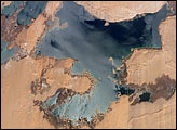
Nearly six years of regional drought and rapidly increasing demand for water have resulted in decreasing water levels in lakes throughout East Africa. The flooded regions of the Toshka Lakes west of Lake Nasser have decreased greatly over the years, exposing the former dune fields, and leaving a “bath-tub ring” of wetlands (dark region) surrounding the lake shorelines.
Published Jan 9, 2006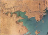
Heavy rains in the source regions of the Nile in the 1990s resulted in record water levels in Lake Nasser. In 1997, Lake Nasser began flooding westward down a spillway into the Toshka depression in southern Egypt, creating four new lakes over the next few years.
Published Jan 2, 2006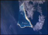
he Republic of Kiribati is an island nation consisting of some 33 atolls near the equator in the central Pacific. Before Europeans found the islands, they had been inhabited for two millennia by indigenous Micronesians. In 1820, the British named the islands the Gilbert Islands, after Captain Thomas Gilbert, who discovered some of the atolls in 1788. The islands eventually gained their independence in the 1970s.
Published Dec 29, 2005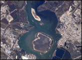
This astronaut photograph depicts the San Jacinto River portion of the Houston Ship Channel, one of the United States’ busiest sea ports. The channel is a conduit between the continental interior and the Gulf of Mexico for both petrochemical products and Midwestern grain. The original watercourse for the channel, Buffalo Bayou, has its headwaters thirty miles to the west of the city of Houston. It has been used to move goods to the sea since at least 1836. Wakes of ships traveling along the channel are visible to the south of the Goat Islands (bright, oblong islands at top center of image). The close proximity to Texas oilfields led to the establishment of numerous petrochemical refineries along the waterway, such as the ExxonMobil Baytown installation on the eastern bank of the San Jacinto River.
Published Dec 26, 2005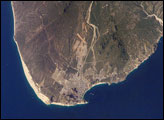
The built-up areas of Cabo (cape) San Lucas stand out as bright, angular areas inland from the main bay on the tip of the Baja California peninsula. Dry river beds descend from rugged, wooded hills to the coastline. River sands then accumulate to form the white beaches visible along the coastline adjacent to the city.
Published Dec 19, 2005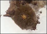
The largest salar (salt flat) in the world, Salar de Uyuni, is located within the Altiplano of Bolivia in South America. This astronaut photograph features the northern end of the salar and the dormant volcano Mount Tunupa (image center). This mountain is high enough to support a summit glacier, and enough rain falls on the windward slopes to provide water for small communities along the base. The dark volcanic rocks comprising Mt. Tunupa are in sharp contrast with the white, mineral-crusted surface of the salar. The major minerals are halite (common table salt) and gypsum (a common component of drywall).
Published Dec 12, 2005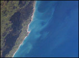
Along the Pacific coast of New Zealand’s North Island, the advance of austral spring returns the sunlight needed to spur phytoplankton blooms. In the center of this slightly enhanced image captured on October 27, 2005, a plume extends from the coastline (near Castlepoint in the southern part of North Island) and rotates in an offshore eddy. Another broader swath of less-intensely colored plankton appears in the lower part of the picture. Both plankton masses are being swept offshore (eastward) by waters of the Antarctic Circumpolar Current.
Published Dec 5, 2005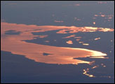
This strongly oblique (from the side) view shows the Gulf of Finland and Lake Ladoga in the late afternoon. At this time of day, sunglint—the reflection of sunlight into the camera lens—distinguishes the bodies of water from their surroundings. The image was taken from the International Space Station when the craft orbited north of the Caspian Sea, approximately 2,500 kilometers (1600 miles) to the southeast on the Russia-Kazakhstan border. Lakes in Finland in the middle of the view are 3,000 kilometers (1900 miles) from the camera.
Published Nov 28, 2005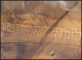
Fans of the Star Wars series of films may recognize the Algodones Dunefield—also known as the Imperial Dunes—as portions of the imaginary planet of Tatooine. While not planetary in scale, this dunefield located at the junction of three states (Arizona and California in the United States; Baja California del Norte in Mexico) is a distinctive feature of North America. The field is approximately 72 kilometers long by 10 kilometers wide (45 miles by 6 miles) and extends along a northwest-southeast line that correlates to the prevailing northerly and westerly wind directions. The dune field is a wilderness area, with the only human structure being the All American Canal that cuts across the southern portion from west to east (right side of view). A checkerboard pattern of farms in the Colorado River flood plain is visible on the Mexican side of the border (far right). Wisps of cloud obscure the Cargo Muchacho Mountains (top).
Published Nov 21, 2005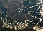
The approximate boundary between Europe and Asia is defined by the Ural River and the Ural Mountains to its north. The Ural River flows to the great inland Caspian Sea and gives its name to the city of Uralsk on its banks. International Space Station astronauts acquired a series of images of Uralsk, highlighting the city under different lighting conditions. This view shows the sunglint (light reflected from the water surface towards the observer) on the rivers, lakes, and ponds of the Ural flood plain (right side of image) and that of a tributary, the Chogan River (bottom). The cityscape of Uralsk, on the headland between the two, is relatively difficult to see because the water and sunglint dominate the scene.
Published Nov 14, 2005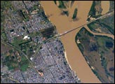
The Paraná River, in the center of the view, has been the principal transportation artery of central South America since the times of early colonization. Consequently, the river gave rise to the growth of port cities such as Argentina’s second city, Rosario (bottom center), now a major industrial center (pop. > 1.1 million). Rosario is the center of a vibrant local agricultural economy—intensive agriculture is visible on the left margin of the view. As such, Rosario is one of the key cities in South America’s MERCOSUR common market (Argentina, Brazil, Paraguay, Uruguay). Other cities have expanded along the river bank, especially northward (for example, Capitan Bermudez, top left).
Published Nov 7, 2005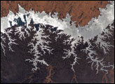
One of the world’s largest artificial lakes, Lake Nasser is named after the Egyptian President Gamal Abdul Nasser, who is largely responsible for the lake’s creation. President Nasser decided to build the Aswan High Dam across the Nile, forming a lake approximately 550 kilometers (340 miles) long.
Published Nov 3, 2005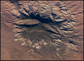
The Colorado Plateau of Arizona, Colorado, New Mexico, and Utah is made of mostly flat-lying layers of sedimentary rock that record paleoclimate extremes ranging from oceans to widespread deserts over the last 1.8 billion years. Navajo Mountain in southeastern Utah is a dome-shaped chunk of igneous rock that intruded into the sedimentary layers and lifted up the overlying layer. Navajo Mountain is one of several of these rock formations, called laccolith by geologists, in southeastern Utah’s portion of the Plateau. This oblique (from-the-side) astronaut photograph highlights Navajo Mountain in the center of the image, surrounded by light red-brown Navajo Sandstone (also visible in the canyon at bottom of the image). The igneous rock at the core of the mountain is wrapped in sedimentary layers. The peak of Navajo Mountain, at approximately 3,148 meters (10,388 feet) elevation, is comprised of uplifted Dakota Sandstone deposited during the Cretaceous Period (approximately 66-138 million years ago).
Published Oct 31, 2005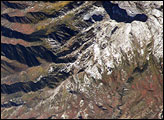
The Wasatch Range forms an impressive backdrop to the Salt Lake City metropolitan area, and it is a frequent destination for hikers, backpackers, and skiers. The range is considered to be the westernmost part of the Rocky Mountains, and rises to elevations of approximately 3,600 meters (12,000 feet) above sea level.
Published Oct 24, 2005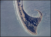
This astronaut photograph, taken from the International Space Station, shows the northernmost parts of the Cape Cod National Seashore, also known as Provincetown Spit.
Published Oct 19, 2005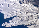
There is no permanent human base on South Georgia Island, a British territory in the South Atlantic Ocean that lies 1,300 kilometers east of the Falkland Islands. The crew of the International Space Station captured this image of the rugged and isolated landscape of the northern shore of the island. The first recorded explorer to land on the island was Captain James Cook aboard the HMS Resolution in 1775. He mapped part of the coastline, but was discouraged by the thick ice cover, lack of vegetation, and steep mountains. Mt. Paget, the highest peak, rises to 2,934 meters (9,625 feet) above sea level, and the island supports 161 glaciers. Cook named the southernmost point of the island “Cape Disappointment” when he realized he had not reached Antarctica.
Published Oct 17, 2005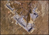
The United States’ highest rate of coal production is in Wyoming, with almost 4 million short tons extracted in 2004. The majority of this coal is burned to generate electrical power within the United States, but a small percentage is also goes to Spain and Canada. The Powder River Basin in the northeastern portion of the state is the most productive of Wyoming’s coal fields. The extensive coal deposits—ranging in thickness from 21 to 53 meters (70 to 175 feet)—formed over 38-66 million years ago. The source of organic material for the coal originated in swamps, estuaries, and deltas associated with the regression (retreat) of a large inland seaway that occupied central North America during the Cretaceous Period, which spanned the years between about 144 to 65 million years ago.
Published Oct 10, 2005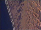
This detailed view of the remote Conception Bay sector of the Namibian coastline shows breakers and a strand plain on the left and complex dunes of the Namib dune sea on the right. A strand plain is a series of dunes, usually associated with and parallel to a beach, sometimes containing small creeks or lakes. The complexity and regularity of dune patterns in the dune sea of the Namib Desert have attracted the attention of geologists for decades; however, they remain poorly understood. The flat strand plain (roughly 4 kilometers shown here) shows a series of wet zones that appear black where seawater seeps inland and evaporates. These patches are aligned with the persistent southerly winds, some of the strongest of any coastal desert.
Published Oct 3, 2005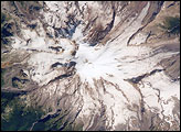
A clear summer day over Washington state provided the International Space Station crew the chance to observe Mt. Rainier—a volcano that overlooks the Seattle metropolitan area and the 2.5 million people who live there. In addition to its presence on the Seattle skyline, Mt. Rainier also looms large among volcanoes in the United States.
Published Sep 26, 2005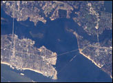
The port town of Biloxi, Mississippi, experienced significant damage when Hurricane Katrina came ashore on August 29, 2005. This astronaut photograph illustrates damage and flooding in the Biloxi area caused by Hurricane Katrina.
Published Sep 19, 2005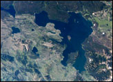
This astronaut photograph is centered on Yellowstone Lake, a popular camping and fishing location within the National Park. The lake basin includes part of the youngest caldera and has an area of 352 square kilometers (136 square miles).
Published Sep 5, 2005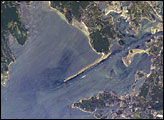
The modern Buzzards Bay is approximately 45 kilometers long by 12 kilometers wide and is a popular destination for fishing, boating, and tourism. The Cape Cod Canal allows for passage between Buzzards Bay and Cape Cod Bay to the northeast; the wakes of numerous pleasure craft appear along the length of the Canal.
Published Aug 29, 2005
This view of Mt McKinley (Denali)—the highest point in North America (6,194 meters; 20,230 feet)—looks as if it were taken from an aircraft. In fact, an astronaut onboard the International Space Station took advantage of cloud-free skies and a powerful 800-millimeter lens to photograph this peak while the spacecraft was over the Gulf of Alaska, 800 miles to the south of the mountain. The powerful lenses are difficult to use, requiring motion compensation by the astronaut, so these kinds of detailed images of horizon detail are seldom taken. The rising sun casts long shadows across the Kahiltna Glacier that angles down from Denali (left).
Published Aug 22, 2005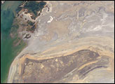
The arrow-shaped island in the Aral Sea used to be a 35-kilometer-long visual marker, indicating the Aral Sea to astronauts. An image from the present International Space Station increment shows how much the coastline has changed as the sea level has dropped during the last three decades.
Published Aug 15, 2005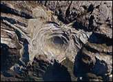
Located in the Sudirman Mountains of the Irian Jaya province of Indonesia, the Grasberg complex is one of the largest gold and copper mining operations in the world.
Published Aug 1, 2005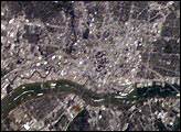
The Dallas-Fort Worth metropolitan area is the largest in Texas, with an approximate population of 6 million people in 2005.
Published Jul 25, 2005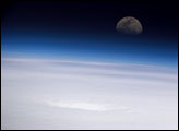
This unusual high-oblique (from the side) panoramic view of the eye of Hurricane Emily in 2005 was shot by the crew of the International Space Station while they passed over the southern Gulf of Mexico looking eastward toward the rising moon. The eye appears as a depression in the cloud deck, which stretches out to the horizon and fades into the limb (the bright blue cross-section) of the Earth’s atmosphere. At the time this image was taken, Emily was a strengthening Category 4 hurricane with wind speeds approaching 155 miles per hour. The hurricane was moving west-northwest over the northwest Caribbean Sea about 135 miles southwest of Kingston, Jamaica.
Published Jul 20, 2005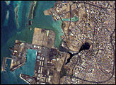
The city of Jeddah is the second largest city in Saudi Arabia (after Riyadh), and is the country’s most important Red Sea port. This astronaut photograph depicts the downtown district of Al Balad, a residential area historically (and presently) occupied by wealthy merchants.
Published Jul 18, 2005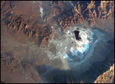
Searles Lake is known for the abundance of rare elements and evaporate minerals, such as trona, hanksite, and halite formed within its sediments. Evaporites are minerals that are left behind when saltwater evaporates. This astronaut photograph depicts the Searles Lake playa (characterized by white surface mineral deposits) bounded by the Argus and Slate Mountains. The width of the playa is approximately 10 kilometers. The center of the image is dominated by mining operations that extract sodium- and potassium-rich minerals (primarily borax and salt) for industrial use.
Published Jul 11, 2005