

Satellite Data for Agricultural Monitoring
Food security and agriculture is probably not the first thing that comes to mind when you think about satellites being launched into space and orbiting planet Earth. You might even be surprised to learn that NASA, best known for its space exploration, actually has over a dozen satellite missions dedicated to monitoring food production, land changes, and vegetation. Truth be told, the data provided by these Earth observing satellites provides critical information for analyzing the state of food production and food security around the world. From space, we can see things like the NDVI (namely, green light reflectance) of plants which is indicative of crop health, crop damage resulting from natural disasters (such as the 2020 Iowa derecho), and even the amount of moisture stored deep within farmland soil. However, compiling these large satellite datasets into deep time series to monitor interannual and within-season changes in vegetation requires a lot of skill, computational power, and time.
The Legacy Global Agricultural Monitoring System Gets an Update
In the early days of satellite Earth observations, the University of Maryland worked together with NASA and USDA to develop the first web-based platform to enable near-real-time monitoring of global croplands, enabling users across the globe to track crop conditions as growing seasons unfolded (re. Monitoring Global Croplands with Coarse Resolution Earth Observations: The Global Agriculture Monitoring (GLAM) Project). After years of operational use and a lot of valuable feedback from partners, the time came to redesign this system – known as Global Agricultural Monitoring or GLAM – to be faster, more flexible, and to capitalize new datasets coming online and new computing architectures available. Thanks to funding from NASA ESDS and NASA Applied Sciences, the team at NASA Harvest (NASA’s Food Security and Agriculture Program) has accomplished just that.
New GLAM System Features, Datasets, and Functionalities
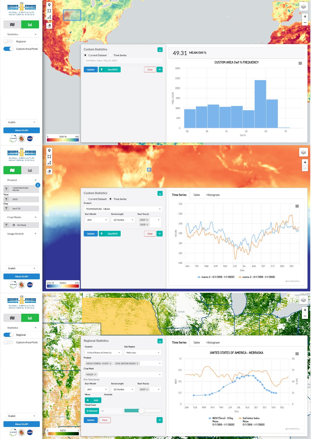
Now lightning-fast due to back-end developments that drastically reduce processing time, the new GLAM system includes many new functions. Users can access the publicly-available web-interface from anywhere in the world, as all processing takes place on “the cloud” and does not rely on local bandwidth to compile datasets. They can use the interface to pan around the globe to a region of interest. They can select an administrative boundary or draw a custom polygon to investigate. They can select from a variety of cropland and crop type masks to target relevant croplands, and then create custom time series charts with the ability to calculate mean and anomaly for datasets over time. Because cloud cover is a common issue in many agricultural regions and cultivation periods, users can customize their cloud cover tolerance in plotting and displaying imagery as well. Furthermore, users also have the ability to overplot crop calendar information on their time series plots, which provides important context to compare crop conditions between years.
In addition to these new functions and features, the interface includes multiple new datasets to help analysts glean insight into the drivers behind anomalous crop conditions throughout the world. Currently, the new GLAM system includes 8-day and 16-day NDVI datasets from NASA’s Moderate Resolution Imaging Spectroradiometer (MODIS), CHIRPS Precipitation datasets from the University of California Santa Barbara Climate Hazards Center, Soil Water Index from the Copernicus Global Land Service, and Temperature datasets from NASA’s MERRA-2 product, with more datasets on the way.

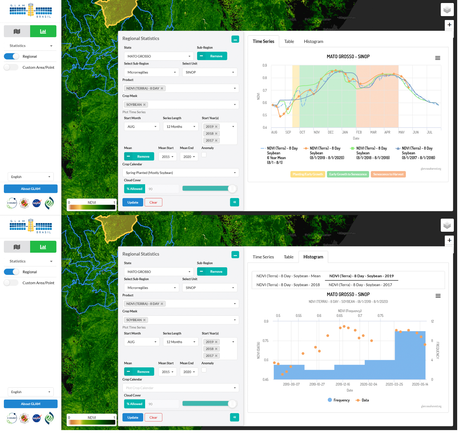
In addition to the existing global interface, there are also national GLAM system implementations planned and already operational. First up is the Conab Brasil customized GLAM interface, which was developed and tested hand-in-hand with NASA Harvest counterparts at Conab. Conab is a public company, operationally mandated by the Ministry of Agriculture, Livestock and Food Supply to produce area, yield and production estimates regarding several major commodity crops to the Brazilian government. While users can still view and implement all of the same types of datasets offered in the global system, the Brasil GLAM website offers additional features. While the global site does include regional statistics at the subnational level, the Brazilian site goes beyond the subnational level. In response to Brazilian administrative regional needs, this application includes extra Brazil-specific crop masks as well as extra levels of analysis.
What’s Ahead
The updated GLAM system has already been widely used to flag potential crop impacts especially in Argentina, as featured by the country’s largest media outlet La Nacion. In addition to the system’s current capabilities, planned features include the ability to upload custom geometry (for example, shp, kml, geojson) to retrieve dataset statistics and visualization of dataset anomaly in order to provide users with an indication of the relative performance of a crop over time. The team is also preparing to integrate moderate resolution satellite data sets, for example Landsat, Sentinel, and the Hybrid Landsat-Sentinel products, to move us into this new era of continuous land monitoring at 30 meters or finer resolution. Additionally, the serverless architecture enables us to quickly spin up and launch new GLAM systems for other regions and users.
Are you interested in your own GLAM system? Contact project PI Alyssa Whitcraft.
How We Accomplished It
By using Amazon Web Services (AWS) and “serverless” architecture, the NASA Harvest team has been able to create both a web application and application programming interface (API) that provides on-the-fly data projection, masking, color table application, image differencing, and statistics calculation. As a result, it is not necessary to pre-generate all permutations of the NDVI datasets that would previously have been generated in on-premises architecture. Likewise, it is also not necessary to reproject the global NDVI datasets with the new GLAM system. The on-the-fly capabilities reduce the storage demand to the volume of only the NDVI files (less than ten terabytes) as opposed to the hundreds of terabytes required by the previous on-premises architecture version. In addition, because these functions are done on the spot, the collection of datasets, crop masks, and color ramps can be arbitrary. Therefore, the system does not need to be limited to NDVI and can be expanded to include precipitation, soil moisture, or any other raster dataset.
