CYGNSS was launched on December 15, 2016 at 13:27:21 UTC and today marks the completion of its third year on orbit. Much has happened in that time and the future looks very promising, with all eight microsatellites healthy and operating continuously in their nominal science data-taking mode. Year 1 was spent on engineering commissioning and initial ocean wind measurements. In year 2, the ocean wind retrievals were refined and characterized and investigations of observations over land began in earnest. This past year has seen progress on several fronts. An important refinement to the engineering calibration has been developed. Ocean wind measurements in tropical cyclones have been successfully introduced into numerical hurricane forecast models. And the ability to image inland waterbodies with high resolution has been leveraged to demonstrate two new measurement capabilities.
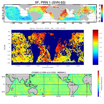
CYGNSS measures the strength of GPS signals reflected by the Earth surface, from which properties of the surface are derived. To do this accurately requires knowledge of the signal strength transmitted by the GPS satellite. The original approach to calibration assumed each GPS satellite had a unique transmit power level and that it did not vary in time. The unique power levels were estimated using measurements averaged over several months. Subsequent analysis has revealed that GPS transmit power can vary significantly, depending on the particular satellite and on its position in orbit. In order to compensate for the changes, the direct signal GPS receivers on all eight CYGNSS satellites were reprogrammed in 2018 to act as power meters which can monitor the variations in transmit power [Wang et al., 2019. A Real-Time EIRP Level 1 Calibration Algorithm for the CYGNSS Mission using the Zenith Measurements. Proc. IGARSS 2019]. The impact of this change is illustrated in the following figure. The top panel shows the geographical distribution of the average error in CYGNSS wind speed for a single GPS transmitter (SVN 63) assuming its transmit power is constant. The center panel shows the actual GPS transmit power as measured by the new on-board monitoring system. Clear localized differences in the measured power are evident which correlate with the errors in wind speed. The bottom panel shows the distribution of average wind speed error after the monitored power is incorporated into the calibration. The discrepancies have been largely removed.
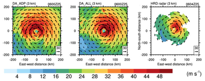
Over the past year, CYGNSS ocean wind measurements have been added to the HWRF numerical forecast model used by the National Hurricane Center and compared to the standard operational forecast, which does not yet use CYGNSS. To forecast a hurricane, HWRF is first initialized with satellite, airborne, and ground based measurements. The storm is then allowed to develop in software, guided by underlying physical principles of thermodynamics, radiation and mass and energy conservation. An example of this is shown in the following figure, which presents three versions of the horizontal wind speed at 3 km altitude for Hurricane Harvey on 25 Aug 2018 at 06Z. The left panel is the 24 hr forecast predicted on 24 Aug by the operational version of HWRF without CYGNSS data. The center panel is the HWRF prediction with CYGNSS winds included. Note the azimuthal shift in predicted peak winds into the northeast quadrant when CYGNSS winds are included. The right panel shows measurements made by NOAA’s airborne doppler radar of the actual winds at 3 km. The predicted azimuthal shift is confirmed, suggesting that the storm’s development is being more accurately modeled [Cui et al, 2019. A Preliminary Impact Study of CYGNSS Ocean Surface Wind Speeds on Numerical Simulations of Hurricanes. Geophys. Res. Ltrs.].
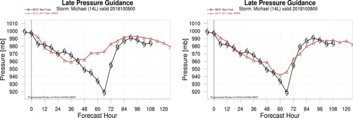
More accurate modeling of storm development should help forecast the intensity of its surface winds, and this has been demonstrated by another study using HWRF [Annane et al., 2018. Impact of CYGNSS Data on Tropical Cyclone Analysis and Forecasts Using the Operational HWRF. 33rd AMS Conf. Hurricanes Trop. Meteo.]. In this case, a 120 hr forecast of minimum sea level pressure (MSLP) in the eye of Hurricane Michael was conducted on 8 Oct 2018 at 00Z without and with CYGNSS winds included as one of the inputs. The left panel in the following figure shows the true (best track) MSLP in black and the operational forecast (without CYGNSS) in red. The rapid drop in MSLP that occurred between ~30-60 hr is not well forecast. The right panel shows the HWRF forecast with CYGNSS winds included and can be seen to more accurately predict the rapid intensification of the storm.
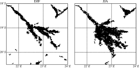
CYGNSS measurements over land are able to provide high resolution tracks across inland waterbodies when the surface is calm enough to support coherent specular scattering. A new land/water mask has been developed which leverages this capability as well as the ability of CYGNSS to penetrate through clouds, rain and vegetation canopies. As a result, dynamic changes in waterbodies (e.g. due to flooding, seasons or human development) can be resolved better than existing water masks that rely on optical satellite imagers. [Gerlein-Safdi and Ruf, 2019. A CYGNSS-Based Algorithm for the Detection of Inland Waterbodies, Geophys. Res. Ltrs.]. An example of this new capability is shown in the seasonal watermasks of the Okavango Delta in Botswana derived from CYGNSS overpasses in 2018. The left panel, for Dec/Jan/Feb, shows the typical river boundaries that are present during the dry season. The mask in the right panel, for Jun/Jul/Aug, captures the widespread flooding which occurs during the rainy season.
CYGNSS overpasses of rivers also produce high resolution tracks that can be used to measure a river’s width and infer its streamflow rate. This has been successfully demonstrated using overpasses of the Pascagoula River in Mississippi during a major flood event in April 2019 [Warnock and Ruf, 2019. Response to Variations in River Flowrate by a Spaceborne GNSS-R River Width Estimator, Remote Sens.]. Streamflow measurements by a USGS river gauge made before, during and after the event are shown in the upper panel below, together with markers at the times of each of five overpasses by CYGNSS. The lower panel shows the Associated GNSS-R Width (AGW) of the river derived from each CYGNSS overpass, together with the Pascagoula’s streamflow rate at the time.
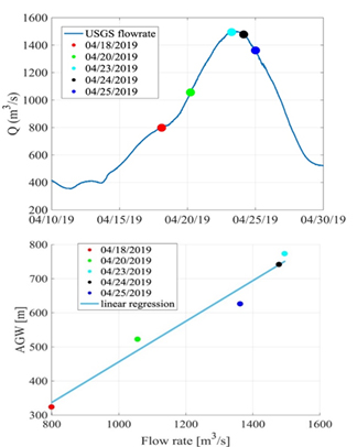
The two are highly correlated, suggesting that another new type of CYGNSS data product may be possible over inland waterbodies.


