By Eric Lindstrom

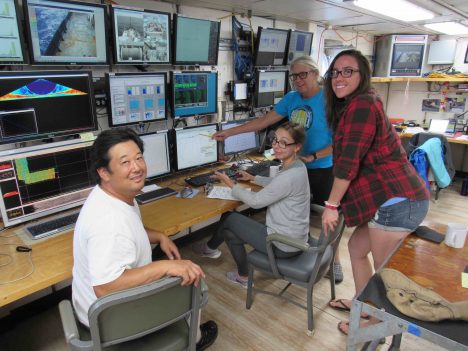
The CTD team (Spencer, Leah, Janet, and Kristin).
The focus of SPURS-2 is the upper ocean and the fate of rainwater. However, in order to study the top of the ocean one needs to know what is going on deeper down. The beauty of SPURS-2 is not skin-deep! SPURS-2, like many prior physical oceanography experiments, requires a basic background and context of the ocean circulation environment upon which many of our other more specialized or detailed measurements can be interpreted. The two major pieces of the contextual information for us are the surface circulation and the surface salinity pattern.
The surface salinity pattern is provided by remote sensing for the largest scale and by the array of drifters and profiling floats that have been deployed with salinity sensors. Also, the R/V Revelle is collecting a treasure trove of upper ocean salinity measurements wherever she goes – with continuous underway measurements of salinity from intakes at the surface, 2 meters (6.5 feet), 3 meters (9.8 feet), and 5 meters (16.4 feet) depths. I’ll go into that in more detail in a later blog on the Surface Salinity Profiler.
The surface circulation of the ocean is largely the result of the wind and the shape of the massive deep layers below the surface. In fact it can be crudely estimated if one knows the precise shape of the thermocline – the boundary between the warm upper ocean and the vast deep cold ocean. Here in the tropics the thermocline is pretty well represented by the 20°C (68° F) isotherm. Think of the warm upper ocean as all the water warmer than 20°C and the layer below as all the water colder than 20°C. Tropical oceanographers can use the depth of the 20°C isotherm much like meteorologists use surface atmospheric pressure maps to chart the highs and lows of weather and their associated winds. Here, if the 20°C isotherm rises toward the surface locally it is associated with a counterclockwise ocean surface current. The signature of the westward North Equatorial Current is a gentle slope of the isotherm from deeper in the north to shallower in the south. This is where our Conductivity-Temperature-Depth (CTD) instrument comes into the SPURS-2 plan. We can use it to track the shape of the thermocline. I wrote about the CTD during the SPURS-1 campaign. It is still the workhorse of physical oceanography – or maybe the monkey on the back of every physical oceanographer! Our show seldom goes on without it.

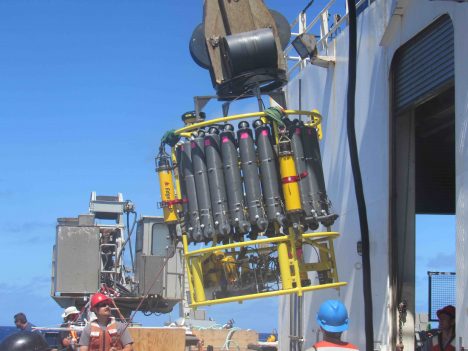
Preparing the CTD to go over the side.
Janet Sprintall from Scripps Institution of Oceanography and her team (Spencer Kawamoto, Leah Trafford, and Kristin Fitzmorris) are now mapping the temperature and salinity structure of the ocean well into the deep cold abyss (to 1.5 kilometers –0.93 miles– below the surface). The ocean depth is about 4.5 kilometers (2.8 miles) and the lower 3 kilometers (1.86 miles) are (for our purposes) relatively uniform and cold. Janet has planned a grid of 49 stations 30 miles apart around the SPURS-2 central mooring. These will be completed over about a week’s time. Simultaneously there will be regular sampling with the Surface Salinity Profiler between some of the CTD stations and we will optimize our meteorological measurements by limiting our speed to 10 knots (11.5 mph). So, while studies of the meteorology and near surface salinity are ongoing, as we move about the ocean, Revelle stops for an hour every 30 miles to collect necessary information on the background oceanographic conditions.
The CTD instrumentation remains largely unchanged (although perfected) in recent decades. Temperature, salinity, and oxygen sensors are mounted on the bottom of a large frame. Water sample bottles are mounted around the outside of the frame. Other instruments, such at the acoustic Doppler current profiler, may also be mounted on the frame. All data is transmitted up the conducting wire cable that is used to raise and lower the instrument. This bulky package is now easier to deploy and recover than in yesteryear due to innovations on today’s vessels. Now the Revelle has a specialized mechanical arm to get the CTD over the side and back on deck safely without much human intervention.

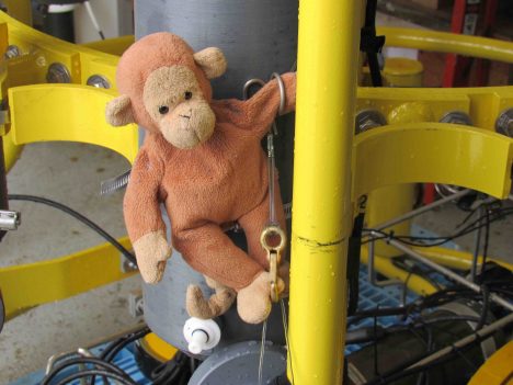
Monkey climbing over the water sample bottles on the CTD.
For my entire career oceanography has been spelled “CTD.” Knowing the temperature and salinity structure from surface to ocean depths is the key to our understanding of the ocean’s role in climate. The first global mapping of these characteristics (with CTDs) was not realized until the World Ocean Circulation Experiment in the 1990’s. Now oceanographers are working hard to understand all the physical, chemical, and biological changes associated with global warming, rising carbon dioxide levels, and industrial fishing. In that big picture, SPURS-2 might look like a small bit of monkey business over the tropical thermocline. However, we know that the resulting scientific understanding will long outlive the memory of our tiny field program in this vast Pacific Ocean!
Tags: climate, oceanography, Pacific Ocean, precipitation, salinity, SPURS2, surface salinity


