
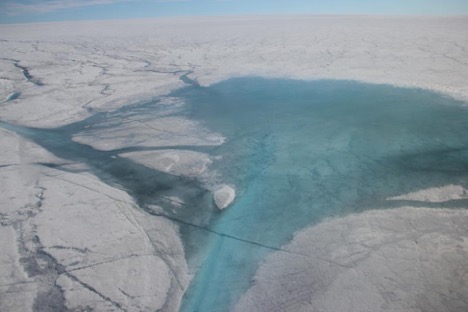
Lake and Rio Behar views from the helicopter. Photo by Clément Miège.
This summer, we have the chance to be part of a team of researchers studying the efficiency of the drainage system over the ablation zone of the Greenland ice sheet. This NASA Cryosphere program funded project, titled “Drainage Efficiency of the Greenland Ice Sheet” is studying the production, transport and export of Greenland Ice Sheet meltwater and its importance for global sea level rise. Each summer, a complex yet poorly studied system of thermally eroded meltwater streams forms across the surface of the Greenland Ice Sheet and transports meltwater into the ice sheet via moulins. Meltwater then exits the Greenland Ice Sheet and makes its way to the global ocean via land-based proglacial rivers and buoyant sediment rich plumes. This project intensively maps, monitors and measures both supraglacial and proglacial rivers to improve estimates of Greenland Ice Sheet surface mass balance and its impacts on global sea level rise.
To achieve these objectives this project will:
- Monitor meltwater outflow through proglacial rivers
- Study cryo-hydrologic processes on the edge of the Greenland Ice Sheet
- Intensively monitor a supraglacial hydrologic catchment in the mid ablation zone of the western Greenland Ice Sheet
- Monitor surface ablation
- Understand the proprieties of the weathering crust and its links to supraglacial rivers
To do this work, we will be located in the ablation zone of Greenland ice sheet, at about 80 km from Kangerlussuaq (the closest town) and 1200 m elevation. Our study site is located right next to a lake and a river called the Rio Behar. As you can see from the photo above, this part of the ice sheet is covered by lakes and rivers that are transporting meltwater away from the ice sheet throughout this connected system.
To study this area, we have researchers from different universities coming in with different background, therefore bringing various expertise and skills to ensure success of this expeditions. The two main institutions responsible for this work are UCLA (Project PI Larry Smith, and his students Lincoln Pitcher, Matt Cooper, Sarah Cooley) and Rutgers University (Project Co-I Asa Rennermalm, and her students Rohi Muthyala and Sasha Leidman. They were also able to invite a few additional researchers to complete the field team. Brandon Overstreet comes from the University of Wyoming and will be in charge of the river work to measure river flow and discharge. Johnny Ryan is at Aberystwyth University in the UK and will be flying over the entire catchment area with a fixed-wing drone. Charlie Kershner is based at George Mason University and will lead terrestrial lidar scanner (TLS) measurements to get high-resolution surface topography and deduce melting rates. Finally, Clem Miege is at the University of Utah and will be leading ground-penetrating radar measurements to look at the weathering crust and any englacial features.
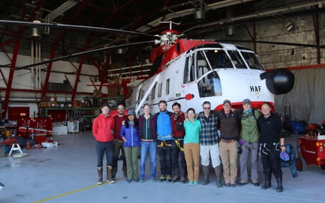
Team posing in front of the helicopter that will take us to our ice camp. From left to right we have: Johnny, Charlie, Rohi, Asa, Matt, Clem, Sarah, Larry, Sacha, Brandon, and Lincoln.
To complement, the ice camp work which will take place between July 4 and July 14, a few team members will also monitor proglacial rivers and streams near the glacier edge. Matt, Sacha, Sarah and Rohi are leading this effort and invited Charlie and Clem to come over and test their equipment on the ice edge. This test day was great, as you can see from the few photos below.
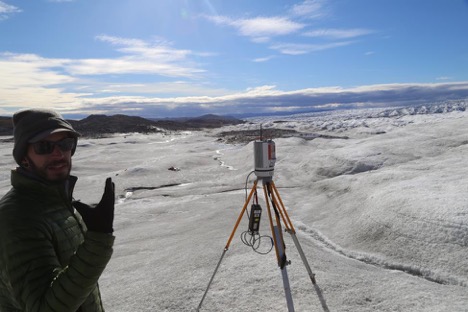
Charlie is testing his Lidar system at the edge of the ice sheet. Photo by Lincoln Pitcher.
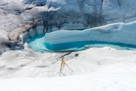
Charlie’s Lidar in action at the river bend. Photo by Charlie Kershner.
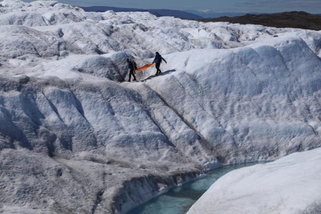
Charlie and Clem are carrying the ground-penetrating radar over the glacier, the surface roughness made it difficult for the radar to operate. Photo by Lincoln Pitcher.
That is about it for now as we are finishing sorting through our equipment before getting to our ice camp.
In the coming posts, we will send updates on how the work is going on the ice sheet and also describe the different components of this multi-disciplinary work in more details. I hope you will enjoy reading about this exciting research project.
Thanks and best wishes,
Clem and Lincoln
Good luck, but I doubt that there´ll be any ice in 10 years with the co2 readings over 400. How long do you think the north pole will have ice ?
Great Ice zone.. thank for sharing your experience in this blog.. I’ve been looking for this kind of blog the whole time.
ottimo, eccezionale
I like the helpful info you supply to your articles. I’ll bookmark your weblog and check again here frequently. I am somewhat sure I will be informed a lot of new stuff proper here! Best of luck for the following!
Efficient meltwater drainage through supraglacial streams and rivers on the southwest Greenland ice sheet
I am shocked each time when I see the ice melt. Arctic Picture book. A long time ago….I bought a table tabletop style beautiful picture book. A book in the 1970 s and it didn’t contain a single picture of what appears now every place it seems. NOW Early Spring thaw, _ the whole arctic looks like early Canadian spring breakup in cottage country…( on a smaller scale of coarse ).
Roderick Allen Paget says….. the whole arctic looks like early Canadian spring breakup////////The 2012 Arctic ice loss had an incredible combination of a powerful ice busting storm & wind shifts that flushed a lot of broken ice to the North Atlantic. 2016 saw a lesser & later storm, AND winds blowing the wrong way. Tho Arctic ice is thinner than years before, it appears that the Arctic will need a timely storm AND ice flushing winds again, to clear the Arctic within the next 10 years. As for Greenland, Grace & IOM data indicate present annual Ice Loss is 350 to 400+ Gts, up from 200 Gts, 10+(?) years ago. When Greenland annual losses rise to 2000+ Gts., it’ll take more than a 100 year record solar radiation TSI low, to keep river deltas from backing up tens of miles.