Numerical weather prediction models can be run with CYGNSS data included before the satellites are even in space. This is the premise behind the Observing System Simulation Experiment, or OSSE. In an OSSE, simulated measurements from any observation platform (past, present, or future) can be assimilated into a model and their impact can then be evaluated by comparing forecasts made with and without those measurements. For an introduction to CYGNSS and how it works, please read this previous blog post.
In an OSSE, the “real world” is actually high-resolution, high-quality model output from a “nature run”. That nature run is the foundation from which all observations are simulated and against which all analyses and forecasts are verified. Since the observing characteristics of instruments are known, “synthetic data” from any existing or future observation platform can be interpolated from the nature run and assigned realistic errors. If you’re living in the nature run, those synthetic data would be what your instruments would measure… including radiosondes, satellites, aircraft, buoys, and yes, even ocean surface wind speed retrievals from CYGNSS. [Note that times, dates, and events associated with the nature run are arbitrary — they do not coincide with specific events in the real world.]

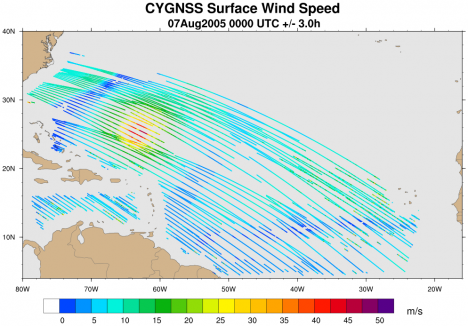
An example of synthetic CYGNSS wind speed data spanning a six hour period over the Atlantic Ocean. A hurricane can be seen north of the Lesser Antilles.
Then, the suite of observations are made available to a data assimilation (DA) system. While there are a variety of DA flavors, the basic idea is that all available observations are taken into consideration in an optimal and dynamically-consistent way to produce a best guess of the current state of the entire atmosphere. This is called the “analysis”.

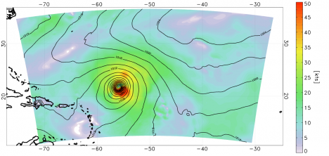
Analysis of the surface wind speed (shaded) and surface pressure (lines) on August 5 at 0000 UTC. The data assimilation method used here was a 3-D variational analysis scheme called GSI. This includes all available CYGNSS data within +/- 3 hours of the analysis time, as well as many other conventional data types.
The analysis provides the initial state for a forecast model. The forecast model, which must not be the same model used to generate the nature run, is integrated out in time. A short-term forecast (e.g. 6 hours) is used as the “background”, or first guess, for the next cycle’s analysis. Typically, the further out a forecast is run, the more it deviates from reality due to model errors, observation errors, and chaos.
The forecast model is used to produce a “control run”, which is one that includes a fixed set of observations or has a particular model configuration. Any additional data or tweaks to the DA/model system would be used to generate different runs, or experiments (“what happens if we add this”, or “what happens if we change that”). The model run is verified against the nature run by calculating errors in the analyses and forecasts — remember, the nature run is the real world in an OSSE. Output from each of the experiments can be compared to the control run to test if the errors were reduced or increased. Ideally, the addition of a new observation type such as CYGNSS improves upon the control run, but it is not always so simple in practice.
The plots below show errors in peak surface wind speed, minimum central pressure, and track for a tropical cyclone in the nature run from a control run (black line) and a single experiment with realistic CYGNSS data (red line). All of the errors from twelve forecast cycles are averaged together at the analysis time (0 hour), at 6 hours, and so on out through 120 hours. This is only an example from a single experiment, but other experiments conducted by our team include varying the DA cycling frequency, introducing “perfect” CYGNSS data interpolated directly from the nature run, adding realistic directions to the wind speeds, and assimilating higher-resolution CYGNSS data.

Errors in peak surface wind (left), minimum central pressure (middle), and track (right) for the control run (black line) and an experiment in which realistic CYGNSS data were introduced (red line). Note that lower error is ‘up’ on the y-axis on the left panel.
Based on results from a single tropical cyclone in a single nature run, simulated CYGNSS surface wind speed data do seem to have a positive impact on both analyses and short-range forecasts of tropical cyclone intensity. However, the impact on tropical cyclone track is not very noticeable, likely due to the limited influence of surface wind speeds on the storm’s steering levels.
Now we wait (im)patiently for when real data get collected and assimilated into models!
–Brian is a Senior Research Associate at the University of Miami’s Rosenstiel School of Marine and Atmospheric Science, and also blogs about hurricanes for the Washington Post.
Tags: CYGNSS, OSSE, tropical cyclones


