
The global ocean is made up of five major ocean basins: the Pacific, Atlantic, Indian, Southern and Arctic Ocean. The Pacific Ocean is the largest of these basins as well as the deepest. Its expanse runs 155 million square miles and contains “more than half of the free water on earth.” Not only is it the largest and deepest ocean basin, but it is also the oldest, comprised of rocks that have been dated to be 200 million years old. You may have heard the term “Ring of Fire” associated with the Pacific Ocean. This name stems from the fact that the Pacific Ocean is prone to earthquakes and formation of submarine volcanoes along its extensive ridge and trench systems.
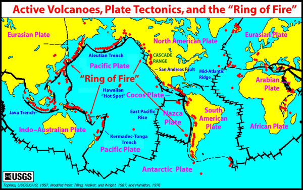
Ring of Fire
http://oceanexplorer.noaa.gov/explorations/05fire/background/volcanism/media/tectonics_world_map.html
The Pacific Ocean gained its name in the 16th century from the Portuguese navigator Ferdinand Magellan. Magellan and his crew set sail from Spain in 1519 in search of the Spice Islands located to the northeast of Indonesia. The Spice Islands were the largest producers in the world of spices such as nutmeg, cloves, and pepper. They navigated through the Atlantic Ocean and around the tip of South America after which they came across an unfamiliar ocean. He called this ocean ‘pacific’ which means peaceful. Unbeknownst to them, they still had a long journey to the Spice Islands. You can learn more about the voyage of Magellan and his crew here.
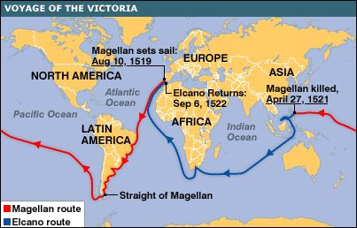
Magellan’s Voyage
http://news.bbc.co.uk/2/hi/science/nature/6170346.stm
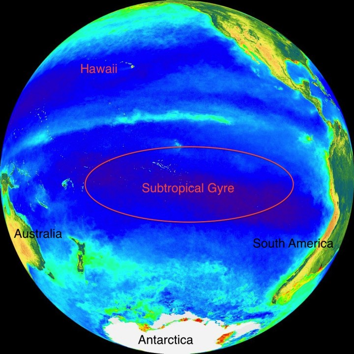
OK, back to science! The CLIVAR P16S field campaign has entered the waters of the South Pacific known as a subtropical gyre. Gyre means “circular or spiral motion.” In the ocean, wind generated surface currents travel in a circular direction, either clockwise or counterclockwise, forming a large, circular body of water. The circular direction of the currents is caused by the Coriolis Force acting to deflect motion to the right in the Northern Hemisphere and to the left in the Southern Hemisphere due to the Earth’s rotation. The South Pacific gyre is located in the Southern Hemisphere, so winds and water are deflected to the left. Because of the deflection to the left, the gyre circulates in the counterclockwise direction, forcing water to pile up in the center of the gyre. In the last post, “An Appreciation for True-Color Satellite Imagery” we discussed how microscopic plants, or phytoplankton, require nutrients to grow. Blooms (large cell numbers) of phytoplankton cannot grow in these gyres because the water that piles up within the center of circulation is nutrient deficient.
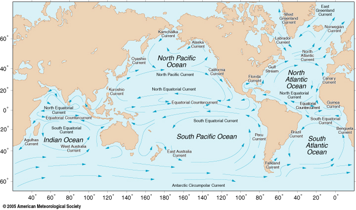
Global Ocean Circulation
http://oceanmotion.org/html/background/wind-driven-surface.htm
We can use the information about the color of the light being absorbed and reflected by the ocean to deduce the concentration of phytoplankton biomass using the proxy Chlorophyll a. Chlorophyll a is a pigment that both land plants and phytoplankton use to convert light to sugars in their chloroplast. Chlorophyll a absorbs strongly in the blue color of light. So when there is a lot of Chlorophyll a, then the light reflected back includes very little blue light. When there is very little or no Chlorophyll a, then a lot of blue light is reflected back. The figure below is an ocean color image based on the information I just described. The blue color represents little to no Chlorophyll a (or phytoplankton) present while the bright colors of yellow green and red represent increasing concentration of Chlorophyll a or phytoplankton biomass.
SeaWiFS Ocean Color image, Pacific Ocean
http://oceancolor.gsfc.nasa.gov/cgi/image_archive.cgi?c=CHLOROPHYLL
Please bear in mind that this explanation is very simplistic. You can learn more about how ocean color works here.
See the image below for the current cruise track of CLIVAR P16S. They are almost in Tahiti. Just a couple more weeks…
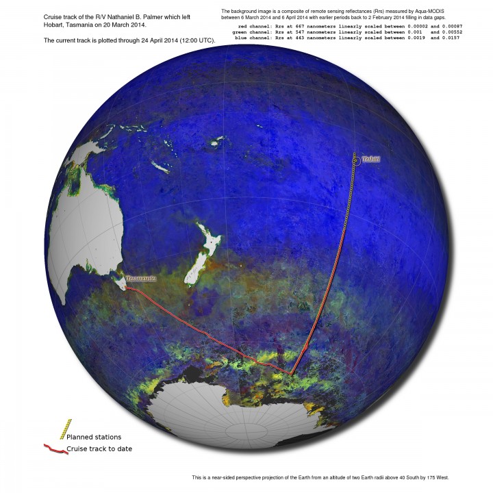
Cruise Track, CLIVAR-P16S
ACKNOWLEDGEMENTS: NASA’s Ocean Ecology Laboratory Field Support Group is participating in the US Repeat Hydrography, P16S field campaign under the auspices of the International Global Ocean Ship-Based Hydrographic Investigations Program (GO-SHIP). The US Climate Variability and Predictability Program (CLIVAR), NOAA and the NSF sponsor this campaign.

http://oceanservice.noaa.gov/facts/biggestocean.html
http://oceanservice.noaa.gov/facts/pacific.html
http://www.iol.ie/~spice/Indones.htm
http://www.rmg.co.uk/explore/sea-and-ships/facts/faqs/what-and-where-are-the-spice-islands
http://news.bbc.co.uk/2/hi/science/nature/6170346.stm
http://www.merriam-webster.com/dictionary/gyre
http://ww2010.atmos.uiuc.edu/(Gh)/guides/mtr/fw/crls.rxml
http://oceanworld.tamu.edu/students/currents/currents3.htm
http://oceancolor.gsfc.nasa.gov/cgi/image_archive.cgi?c=CHLOROPHYLL
http://oceancolor.gsfc.nasa.gov/SeaWiFS/
Tags: Clivar, field sampling, NASA, ocean color, oceanography, optics, phytoplankton, South Pacific, subtropical gyre
Thank you very much for your explanations and graphics, they are wonderfully understandable. They’ve helped me understand the importance of the oxygen analysis work my son Andrew is doing on the Palmer.
Thank you so much for this Pamela O’Connor
I’ve enjoyed reading your blog from time to time. You’ve done a great service continuing the discussion of world-wide pollution issues, as well as demonstrating how interesting a job in science can be. Good job!