By Eric Lindstrom

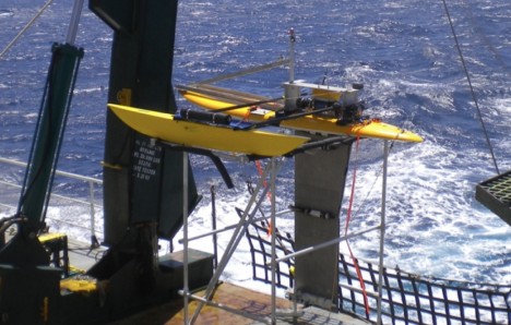
The Surface Salinity Profiler from University of Washington’s Applied Physics Lab, shown here while it was being tested at sea, is now deployed on R/V Thalassa.
The SPURS experiment involves not only sea-going oceanographers but modelers, and of course, remote sensing scientists using satellite data. As part of the daily posts from R/V Knorr I will go into more detail on the role of the models and satellite data in the overall scientific enterprise. I will profile the modeling teams and their interaction with the ship-based team during the voyage.
Numerical models of the ocean, run on supercomputers, can provide high-resolution animations of the physical environment for us sea-going scientists. In order to actually simulate the environment, the models need to take in data from the expedition and make sure the model solution is one that best fits the available data. This process is called data assimilation. (You are more familiar with data assimilation in models than you think – daily weather maps are the result of models and forecasts are done using data assimilation into sophisticated models of atmospheric physics.)
An objective of SPURS is to provide a high-resolution, near-real-time stream of data that can be assimilated into ocean models. Because the ocean is so big and complex, and our at-sea capacity to measure it so puny, we rely on ocean modeling and data assimilation to help us interpret the environment. The model results can be used in planning work at sea and to diagnose the balance of salinity in the upper ocean. The observations are essential to locking model results into the real oceanographic environment. The model is essential to estimating things we cannot measure directly and expanding upon the interpretations provided by the observations.
In SPURS, we hope that we scientists at sea and those ashore can collaborate through the exchange of data and model results. This was not possible as late as a decade ago. Now we have Internet at sea and can exchange information and results for daily planning and analysis.
I will discuss the synergy of models and data much more during posts from the ship in September.
SPURS as an International Enterprise
The SPURS experiment involves a number of expeditions and nations working in cooperation at the single location in the North Atlantic.
The French R/V Thalassa is in the SPURS region now with one U.S. team aboard from University of Washington’s Applied Physics Laboratory. I will give more details in future posts.
Follow-on U.S. expeditions will use R/V Endeavor from University of Rhode Island to follow-up the measurements of R/V Knorr. The first of these two expeditions is in the spring of 2013 and will service SPURS equipment that requires maintenance after 6 months at sea. That expedition will also do more of the “feature” characterization. A second expedition in the fall of 2013 will recover all the moored equipment and gliders, among other duties.
A Spanish cruise is also planned for next spring. The details of this expedition will be subject of a post.
What’s up next?
Next up will be the loading of R/V Knorr on 5 September and a media event at 10 am that day. We set sail on 9/6 at 10 am.
Tags: Aquarius, Atlantic, oceanography, sea surface salinity, SPURS, SPURS1


Keep it up !! God be with you all !!!