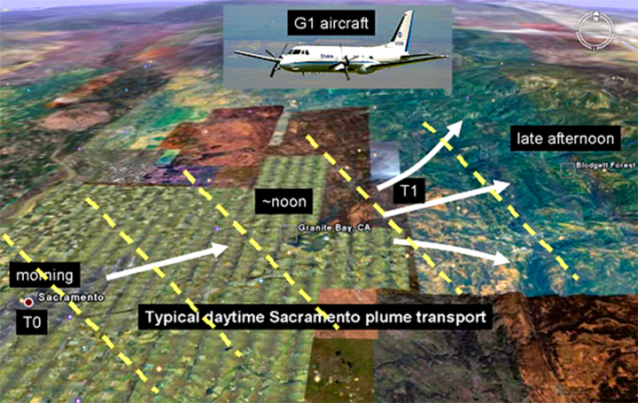
There’s nothing special about Sacramento’s urban emissions per se, other than being very typical emissions from a city. So why was the campaign designed to take place here? The thing is that this region has a very well defined circulation pattern, which makes the plume transport very regular.
Southwesterly winds mix two airflows in the afternoon. The first is a persistent flow originating in the San Francisco Bay area. The second is more local and due to air being heated up in the Sierras, which draws the cooler air from the valley. Unless — there is always an unless — the flow gets disrupted by synoptic (read: large scale) storms born in the Pacific. This is apparently what we have been observing in the first days of the campaign, doomed by an unusual amount of mid-level clouds. NASA’s instruments usually fly at around 8-9 km, and these clouds partly spoil our ability to observe aerosols beneath.

In any case, under normal conditions the resulting upslope flow transports the Sacramento’s plume towards the mountains, where anthropogenic aerosols interact with the biogenic sources from the forested areas, which are loaded with terpenes produced by the photosynthetic activity of vegetation. Recent research has shown that these biogenic sources could give an extra kick to the production of secondary organic aerosols of anthropogenic origin. “Secondary” here designates a zoo of different compounds generated by the interactions of “primary” substances with background conditions, leading to a myriad of chemical and physical transformations. An example? Humidity can coat aerosols of a thin film of water, drastically changing their properties.

The overall goal of the mission is to follow the evolution of the plume, sampling the formation of secondary organics and the anthropogenic/biogenic mixing ratio. Of great avail is the Cool “T1” site downwind from the sources here in Sacramento, packed with instrumentation on the ground managed by the Department of Energy. It’s Cool, like in Cool, CA. This nearly uninhabited site will be regularly overflown by the airplanes involved in the campaign so that data from the different platforms can be compared and validated. You can’t have ground sites everywhere, so that’s why the DOE G-1 airplane samples the area in between, trying to fill the gap and find out what happens in between. Plus there is us – the NASA group. We observe the same aerosols from high above, so we provide scene context. Our instruments are prototypes of those that fly on satellites in space, which are so very important because they give continuous global coverage via the “remote sensing” technique, or “the art of collecting data form a distance”. Very politically correct.
I have to thank Jerome Fast, who has extensive experience as chief meteorologist in campaigns like CARES, for his punctual forecast in the daily briefings and the explanations that prompted this post.
-Matteo
Tags: aerosols, Sacramento


It’ll be interesting to see if this sheds any light on how to reduce air pollution in the SJV.