
The Landsat Data Continuity Mission is now Landsat 8, and that means images are now public (woohoo!). NASA handed control of the satellite to the USGS yesterday (May 30, 2013), and calibrated imagery is available through the Earth Explorer. Unfortunately, the Earth Explorer interface is a bit of a pain, so I’ve put together a guide to make it easier.
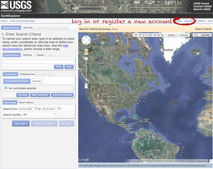
First, go to the Earth Explorer site: earthexplorer.usgs.gov
You can search, but not order data, without logging in—so register if you don’t have an account (don’t worry, it’s instant and free), or log in if you do.
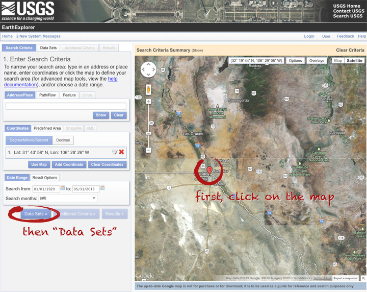
The simplest way to select a location is to simply pick a single point on the map. You can define a box or even a polygon, but that makes it more likely you’ll get images with only partial coverage. Navigate to the location you’re interested in, and click to enter the coordinates. You can choose a data range, but right now there are only 3 or 4 scenes for a given spot, so skip it and just click “Data Sets”.
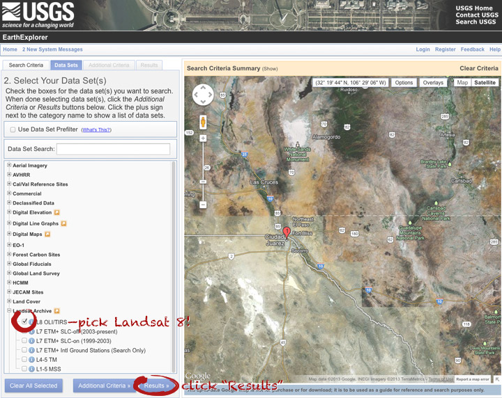
On the data sets page, you can search everything from Aerial Imagery to Vegetation Monitoring. Click the “+” symbol next to Landsat Archive, then the first check box that appears: “L8 OLI/TIRS” (which stands for Landsat 8 Operational Land Imager/Thermal Infrared Sensor (creative, no?)). Click “Results” to start a search.
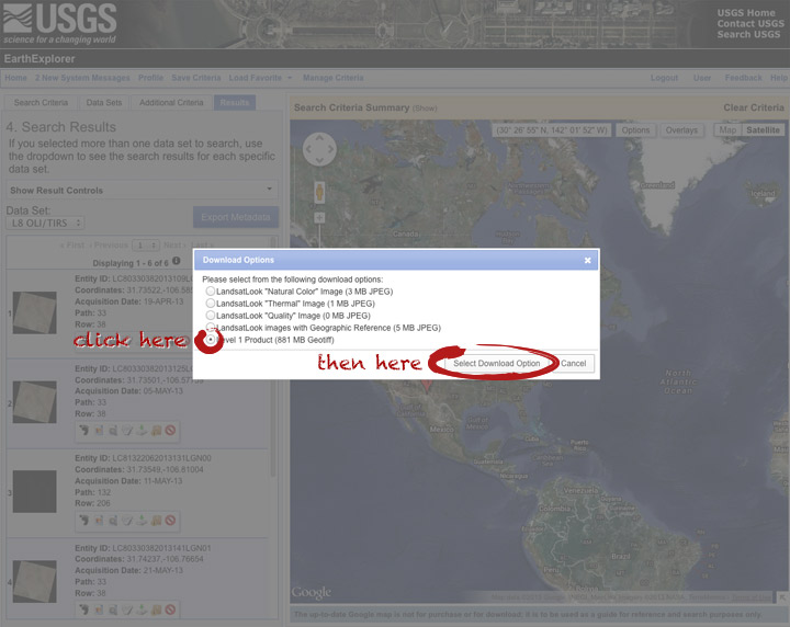
After a short wait, you’ll get a list of available images. The thumbnails aren’t big enough to show much, so click on one to see a slightly larger image. Close that window, and click the download icon: a green arrow pointing down towards a hard drive …
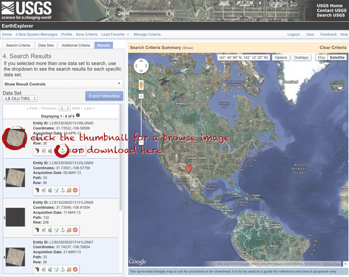
… which doesn’t actually download the data, just provides a list of download options. “LandsatLook” are full-resolution JPEGs, and are a quick way to check image quality (I’d prefer full-resolution browse images without a separate download, but I digress). The Level 1 Product is terrain-corrected, geolocated, calibrated data—a bundle of 16 bit, single-channel GeoTIFFs. Select the “Level 1 Product” radio button, then click “Select Download Option”.
Done! Oh, wait. Not done. You need to click one more button: “Download”.
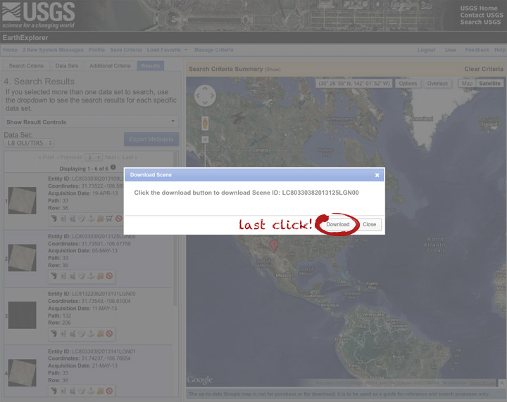
Now you’re done. The data should arrive in your browser’s designated download folder.
Drop a note in the comments section if I’ve skipped a step, or if you have any other questions. Next week I’ll explain what to do with the data once you’ve got it.
Thanks! Can’t wait to learn more!
thanks for the quick review
Very user-friendly instructions – thanks for posting!
Thanks!, useful and easy…
Can I pre-select imagery by choosing a maximum cloudcover amount?
Yes. After you’ve selected the sensor (L8 OLI/TIRS) the “Additional Criteria” tab will become active. Scroll down a bit and pick the acceptable amount of cloud cover.
I’m trying to download some images, but the Level 1 product radio button is grayed out and unclickable. I’m using ENVI to process the imagery and actually need the Level 1 (as part of my dissertation) – the LandsatLook images aren’t really usable as far as I can make out. Do you know whether there is a reason behind this or am I just out of luck?
Are you signed in? There aren’t any restrictions on downloading the data, but you do need an account.
Robert – Thanks for the tutorial. Most appreciated. I received this as a link on FaceBook. Where do I go to get “next” weeks instructions?
I hope you don’t mind if I copy your notes, acknowledging it by you, to provide to my colleagues. I am working as a Australian Volunteer for International Development in the Office of the Provincial Agriculturist in the Philippines and am attempting to help them access better mapping. I am NOT a GIS person so I need all the help I can get.
My first attempt at downwloading a Level 1 product failed – Network error – it was going to take 2 hr and we often don’t get uninterrupted internet for that period. What would be a better option? Currently they will only be ‘looking’ at the maps, or utilising it as a better base layer for mapping activities and land use changes.
Unfortunately, “next week” hasn’t arrived yet. Maybe this week.
If the level 1 data are too big, try the “LandsatLook images with Geographic Reference” They’re JPEG images, but include World Files with the geolocation information (corner points and dimensions). The projection details are in an XML file. I always use the GeoTIFFs, so I don’t know much else about the other formats. You can contact USGS if you need more help.
Thank you.
I downloaded an image from 1980 but when I try and zoom in the image quality is too low can I get a better image( higher resolution) (buy or downlaod free) or is what is downloaded as good as it gets?
thanks
mark
Landsat data is up to 30 meters per pixel in the individual multispectral bands, and the panchromatic band (a wide range of visible wavelengths) is 15 meters per pixel.
Wow, this is incredible. I am just beginning to digest the color information. Meant to send an email applauding the author, Robert Simmon, and would still like to find contact information, but as it is, many a thank you for the lucid and neutral explanation of color.
I just saw that I couldnt click on the last option to choose Level one images. I got an individual account created 3 years ago. Any suggestion?
It works for me. Are you logged in before trying to download?
Trying to download the level 1 products but it’s too long for downloading one single image over 3hours, any suggestions on how i can speed up the downloading process?
Thanks!
Peter:
Landsat 8 data is about 1GB compressed. What’s your download speed?
Thanks from Argentina!!!
please guide me,
How I can select and download my map ,part of a path/row extent ,not all of a path/row extent.