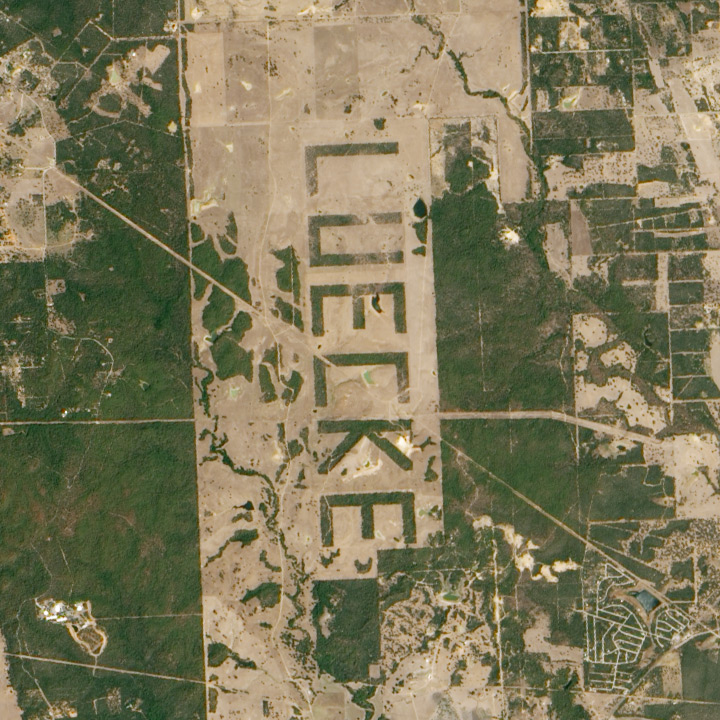
Sometimes I’ll find a surprise in a satellite image. In this case, kilometer-tall letters that spell out “LUECKE” near Austin, TX (Near the Bastrop Fire):

Although this could have just been a curiosity for passing pilots and astronauts, it turns out that Johnson Space Center scientists used the letters to estimate the maximum resolution of cameras aboard the Space Shuttle.
We also made an empirical estimate of spatial resolution for lower contrast vegetation boundaries. By clearing forest so that a pattern would be visible to landing aircraft, a landowner outside Austin, Texas (see also aerial photo in Lisheron 2000), created a target that is also useful for evaluating spatial resolution of astronaut photographs. The forest was selectively cleared in order to spell the landowner’s name ‘LUECKE’ with the remaining trees (figure 10). According to local surveyors who planned the clearing, the plan was to create letters that were 3100 ´ 1700 ft (944.9 ´ 518.2 m). Photographed at a high altitude relative to most Shuttle missions (543 km) with a 250-mm lens, Formula 3 predicts that each pixel would represent an area 28.6 ´ 36.0 m on the ground (table 5). When original film was digitised at 2400 ppi (10.6 mm/pixel), letters correspond to 29.4 ´ 18.8 pixels for a comparable pixel size of 27 – 32 m.
It’s reminiscent of the map of Italy I saw on a hillside near Castellucio, in the Apennines, or even the Nazca Lines. What other examples of landscaping visible from space are out there?


NPR has a good gallery of planetary landscaping. http://n.pr/qcEiYm My favorites: the jellyfish and Mundi Man.
scientists at NASA? This thing was made of trees planted years ago, at least 2005, by a farmer with that name,
Kinda fitting that “Luecke” means gap in German…