
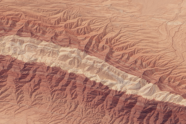
Every month on Earth Matters, we offer a puzzling satellite image. The September 2015 puzzler is above. Your challenge is to use the comments section to tell us what part of the world we are looking at, when the image was acquired, what the image shows, and why the scene is interesting.
How to answer. Your answer can be a few words or several paragraphs. (Try to keep it shorter than 200 words). You might simply tell us what part of the world an image shows. Or you can dig deeper and explain what satellite and instrument produced the image, what spectral bands were used to create it, or what is compelling about some obscure speck in the far corner of an image. If you think something is interesting or noteworthy, tell us about it.
The prize. We can’t offer prize money, but, we can promise you credit and glory (well, maybe just credit). Roughly one week after a puzzler image appears on this blog, we will post an annotated and captioned version as our Image of the Day. In the credits, we’ll acknowledge the person who was first to correctly ID the image. We’ll also recognize people who offer the most interesting tidbits of information about the geological, meteorological, or human processes that have played a role in molding the landscape. Please include your preferred name or alias with your comment. If you work for or attend an institution that you want us to recognize, please mention that as well.
Recent winners. If you’ve won the puzzler in the last few months or work in geospatial imaging, please sit on your hands for at least a day to give others a chance to play.
Releasing Comments. Savvy readers have solved some of our puzzlers after only a few minutes or hours. To give more people a chance to play, we may wait between 24-48 hours before posting the answers we receive in the comment thread.
Good luck!
San Andreas fault
HI
It looks like the Grand Canyon
Death Valley, California
This is durent line between Pakistan border and Afghanistan border
Can’t name the place but it’s a big mountain range cover wth snow and all these
Zhangye Danxia Landform Geological Park in Gansu, China,
These are colourful rainbow mountains. Year 2013.
water divide
Its mountain area…and I think its of Australia….
Almost sure its in China. Possible era taken: Autumn 2014
It looks like water is flowing below the rocks and has changed its color. Chinese have been trying for ages to use those underground Springs to water their vast lands and villages.
Ps. I am not a geologist.
It is in Bahamas.
Himalaya mountain
It’s a mega fold, that’s been eroded on top to reveal the older rocks (whiter rocks) beneath. The closer you go to the center the older the rocks are.
Grand Canyon
The Wave,situated on the Arizona/Utah border.
looks to be in the Atacama Desert in Chile.
Mariana Trench
“The Wave” Arizona–Utah border. Has U-shaped troughs that were eroded into Navajo Sandstone of the Jurassic age.
My wild wild guess is that it could be in Turkey. Maybe in Eastern Turkey. As a cabin crew regularly flying over turkey I see very similar landscapes like this. How it came to be??? Another wild guess is maybe as the mountain terrain formed pushing up maybe it also pushed out revealing the different type of rock/ sediment that was inside the Earth. The earthly colors is what makes it interesting for me.
It is located at Zhangye Danxia Landform Geological Park in Gansu Province, a remote region in northern central China. (‘Danxia’ is the name for a type of rockform, ‘Zhangye’ being this particular location.)
Gobi Desert?? Or, maybe Utah?? I have no idea when the image was acquired, but it’s in the visual band and may be from an airplane rather than satellite. It’s a doubly plunging anticline (i.e., elongated dome) and banding is due to layered strata with varying amounts of iron oxide. The rocks appear to be sandstone and shale, and have been eroded extensively after tectonic compression.
it is inverted topography of the Grand Canyon in the United States, with low areas appearing high.
The Flaming Mountains or Gaochang Mountains.
They
are barren, eroded, red sandstone hills in Tian Shan Mountain range, Xinjiang, China. They lie near the northern rim of the Taklamakan Desert and east of the city of Turpan
I think it is the Atacama Desert in Chile (South America) are rock formations originating in various geological periods.
Probably San Andreas Fault’s Vicinity , or Harbin Spring California.
Eroded syncline (or anticline) – Somewhere with desert! – Middle East/USA… Interesting because the units have initially been deposited in some form of sedimentary environment (think sea/ocean) and then from there they’ve undergone some form of faulting and then been eroded (modern day unconformity) to give the surface expression as visible in the image. It’s interesting because you’ve likely got the youngest geological unit in the middle of the syncline (pale white) – which appears to be at the top of the topography – compared to the older surrounding rock (sand) that makes up the rest of the desert.
its san andreas fault line
Eroded Anticline in North Africa? Perhaps Algeria.
Xinxiang Northern range of mountains bordering the Tarim basin
this is in the Semnan, Garmsar region of Iran, just north of Kavir National Park. It is an area of tectonic activity, with abundant salt deposits, where different era ground materials can be found. It is interesting because it shows extrusion of ground deposits as well as various processes they undergo after reaching the surface. When was it acquired….possibly September 7, 2001 (although this picture looks redder than that on earthobservatory.nasa.gov
Yes, you are right! It was very fun to go search and find it on Google Earth. Thank you. I was really curious about the answer 🙂
How did you know it?
ini sepertinya sebuah gunung di china
Easy one! Rocky Mountains in Utah
It’s a long term scar caused by an asteroid or possible alien crash landing
San Andreas fault or another fault line elsewhere in the world.
Zhangye ‘s Danxia was formed by the erosion of red sandstone, forming isolated peaks and steep stratified outcrops. Its special geological structure, combined with long-term desert conditions , freeze-thaw peeling, and wind and water erosion gave rise to its present appearance.
Geologists believe that Danxia topography is formed by folding of layered oceanic crust. Exposed slanting rock layers have different colors, textures, shapes, sizes, and patterns. The combination of differences in density and erosion create towering peaks, cave holes, and stone halls. Zhangye’s Danxia landscape has lots of precipitous red cliffs, most of which are several hundred meters high, and multicolored ridges of weathered strata, sometimes stretching to the horizon. These formations, sometimes smooth sometimes sharp, stand out against the greens or grays of the plains , looking grand and magnificent, vigorous and virile.
Looks like an upwelling of crust with the geode-like circular patterns caused by decreasing erosion rates as the feature height decreases.
Atacama Desert – Chile
It looks like a doubly plunging anticline (as Phil says)… perhaps in SW Iran. The lighter interior sediment may be salt (halite) as there are numerous salt structures (both circular and linear) formed by compressive forces from the collision of the Arabian peninsula under Iran.
Nambi dessert , South-western Africa. The whitish portion is the dry river-bed. Taken before the arrival of the Tsauchab.
The Atlas Mountains
It looks like San Andreas fault. A continental transform fault that stretches about 800 miles through California.
Oregon High Desert 10-23-2011 Landsat 5 bands 4,5,3. “On the eastern, leeward side of the mountains, the elevation drops, the air warms, and the air pressure increases. This effectively shuts off the rain because the air can better hold the remaining moisture. This effect is called a rain shadow and is largely responsible for the desert landscape beyond the mountains.”
You get a lot of respect from me for writing these helpful articles.
correction on the date acquired: should be 10-27-2011. I posted 10-23-2011.
Rift is what separates the two continental plates in the middle of the Atlantic Ocean.
It is River Nile
It looks like a Digital Elevation Model combined with a satellite view from an anticlinal feature, with older rocks to the centre (light color) and younger around (red to orange); could this anticline related to salt tectonics, for example in the Zagros mountains or in western China?
dear sirs
this the place in Southwest of garmsar (“kuh-e gugerd” the local name) , Iran at the coordinate of 34°54’24.54″E 52°55’44.25″ elevation 1375
good luck
THAR DESERT
This is an anticline with the darker red rocks on the flanks and the lighter rocks in the centre (presumably harder) and forming a mountain range from which the river/erosion systems have originated. Anticlines (folds) and their converse synclines are created during compression and creation of mountains belts The absence of vegetation would suggest a dry desert area,subject to periodic flash floods, perhaps middle east where similar structures sometimes are good oil traps.
A plinleagsy rational answer. Good to hear from you.
sorry NASA
my apologies
the correct place is southeast of garmsar ,iran .the coordinate is same i commented before by the coordinate of 34°54’24.54″ N 52°55’44.25″ E at the elevation of approximately 1375 .
Congratulations!
It is desert encroached area,washed away by wind abrasion.It should be Pakistan desert.
great eroded fold, wherever it is, textbook geology
It is himalayan arch with tibetian plateu n indo gangetic plane
These Rainbow Mountains Are China’s Secret Geological Wonder
Zhangye Danxia Landform Geological Park in Gansu, China, The Danxia national park is located close to the city of Zhangye — about 30 minutes west by car, in northwestern China’s Gansu Province. tourists flock to see China’s own version of the Grand Canyon: A mountain range of densely packed layers of minerals and rock that are dramatically striated into a layer cake of magenta, maroon, and lemon-colored stone. As a new UNESCO World Heritage Site, Danxia is become far more popular these days than it was just a few decades ago, with tourists drawn to the remarkable forms of the mountains here
GEOLOGY OF Zhangye Danxia Landform
How did Danxia come to be, in the geological sense? Over millions of years, layers of different types of rock—including red sandstone and a whole lot of mineral deposits—formed on top of one another. Normal so far. But then, 40 or 50 million years ago, gigantic force of tectonic plates forced an island—the future India—into a collision course with the rest of Eurasia. The catastrophic impact took place in slow motion: Over 50 million years, India—moving at about 27 feet per century—crushed into the larger continent, creating rifts of fractured rock and creating mountain ranges like the Himalayas. Over in the future Chinese province of Gansu, the collision disrupted the layer cake of red rock and minerals, too. Imagine a piece of paper with lines drawn on it—then imagine crumpling it up. The “rainbow” patterns we see at Danxia are the result of a similar crumpling, which explains their perfect striation (1).
Zhangye ‘s Danxia was formed by the erosion of red sandstone, forming isolated peaks and steep stratified outcrops. Its special geological structure, combined with long-term desert conditions, freeze-thaw peeling, and wind and water erosion gave rise to its present appearance.
Geologists believe that Danxia topography is formed by folding of layered oceanic crust. Exposed slanting rock layers have different colors, textures, shapes, sizes, and patterns. The combination of differences in density and erosion create towering peaks, cave holes, and stone halls (2).
When the image was acquired, (Summer)
The weather is comfortable with the strong sun the rocky bands are well defined with colorful stripes, and, if it rains the day before, this color will be more gorgeous. The rest of the year is very dry. Zhangye is well below freezing and windy in winter
what satellite and instrument produced the image, what spectral bands were used to create it:
This band combination is as close to “true color” 4, 3, 2 Band Combinations of Landsat 8 Operational Land Imager (OLI) you can see the high quality image
Chile. Andez separating the Atacama.
– Parallel strata is seen clearly which indicates that it is a sedimentary terrain.
– Central part of satellite image is light coloured which indicates different lithology from surrounding area and may have insufficient water.
– The area is folded may recumbent fold.
-From the image the central portion has a depression.
Iran _ south east of city garmsar near semnan
Atacama desert in Chile,
Looks like a view I’ve seen in one of your posts, that shows a dry canyon floor, probably of one of the tributaries of the Colorado river that runs from the Rocky Mountain in Colorado through the south western USA; It must have dried 2ry to drought that is affecting the area lately!
34° 54′ 32″ N 52° 55′ 31″ E Looks like an anticline, a place where the ground has been folded upwards and the ethereal top of the fold has eroded away showing older rock.layers beneath. The red color is most likely brought to us by iron particles in the sediment that was oxidized (rust, essentially) before ore during the time the grains were being cemented together to make it into rock long ago. That area of the world has very active plate tectonics so lots of earthquakes and deformation.
Just looking at it, you might wonder if it slopes up or down, but if you look at the streams near the top, you can see them starting small clover to the center an then joining together and getting larger as they go toward the top of the image. This would indicate that they are flowing downhill as they go up in the image.
Looks like a large synformal structure which is doubly plunging, as it is forming a closed elongated loop. The beds/strata can be seen exposed along the flanks/slopes of the central hill. The alternating colourful rocks strata must be of a deformed sedimentary sequence. The central lighter region of the hill (lighter because of the light colored rocks present – most probably shales) is the highest part in the image, while it is sloping outwards from the centre. The other reddish-brown colored rocks may be sandstones. The rivers show dendritic drainage pattern.
This must be a part of a regionally folded region. Could be a small part of some folded mountain belt.
Due to the color and total absence of vegetation in the image, I suspect the area captured in the image could be from a desertic or arid region. My guesses about the region: Atlas mountains or some part of western USA.
The image seems to be captured in true color.
Saw the Image of the day version. Cool! I didn’t see where the first correct identifier is named. Can you point it out? Thanks.
Geological structure represents layers of Eocene age andesite and rhyolite volcanic rocks in layers, Karaj Formation contains dacite tuff green, fine-grained and coarse grains is shale Asara. The layers of limestone are also seen in them. Area of poor vegetation cover and only can be Saxaul and tamarisk plants and halophytes in it. The fauna can be hare, porcupine, sand fox, hyena, cat sand, gazella cheetah rarely mentioned.
This is Beautiful Balochistan overlapping Iran, Afghanistan and Pakistan.