
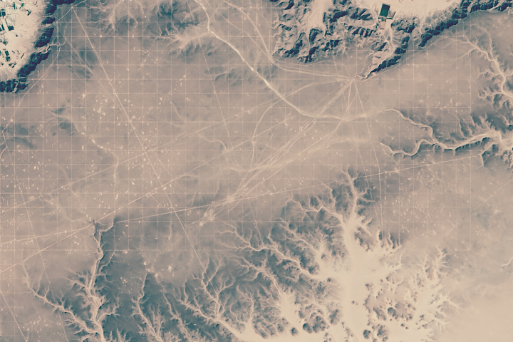
Every month on Earth Matters, we offer a puzzling satellite image. The June 2015 puzzler is above. Your challenge is to use the comments section to tell us what part of the world we are looking at, when the image was acquired, what the image shows, and why the scene is interesting.
How to answer. Your answer can be a few words or several paragraphs. (Try to keep it shorter than 200 words). You might simply tell us what part of the world an image shows. Or you can dig deeper and explain what satellite and instrument produced the image, what spectral bands were used to create it, or what is compelling about some obscure speck in the far corner of an image. If you think something is interesting or noteworthy, tell us about it.
The prize. We can’t offer prize money, but, we can promise you credit and glory (well, maybe just credit). Roughly one week after a puzzler image appears on this blog, we will post an annotated and captioned version as our Image of the Day. In the credits, we’ll acknowledge the person who was first to correctly ID the image. We’ll also recognize people who offer the most interesting tidbits of information about the geological, meteorological, or human processes that have played a role in molding the landscape. Please include your preferred name or alias with your comment. If you work for or attend an institution that you want us to recognize, please mention that as well.
Recent winners. If you’ve won the puzzler in the last few months or work in geospatial imaging, please sit on your hands for at least a day to give others a chance to play.
Releasing Comments. Savvy readers have solved some of our puzzlers after only a few minutes or hours. To give more people a chance to play, we may wait between 24-48 hours before posting the answers we receive in the comment thread.
Good luck!
Abandoned roads of California City
That’s the land division pattern from the times of the settlement. Exactly parcelled with roads/ways along those parcel boundaries.
Oil fields in the Middle East
Forgot to mention where this area is located: western USA.
Erosion? Desertification caused by deforestation?
Utah desert
Mineral exploration
seismic lines in southern libya
These are located in the Tibetan Plateau near the Kumtag Desert. About 10 miles from the Mongolian border. Not sure what the Chinese use them for, but there are many crazy patterns in the area.
Das sind die Nasca-Linien in Peru!
Colorado river delta. The dendritic fan shaped patterns are the sediment laden sleeves of water as they spread out and dry up over the arid flats
Looks like rivers , and mountains for Geological, and either plane geometry for the surveyors of a photographic addition of grid by the camera.
Libyan Desert. The irregular lines are truck tracks following old routes through the featureless dry basin, converging on roads that lead out of the basin. The regular grid shown in the image is created by roads and delineate ~9ha blocks. Maybe for farming or mineral rights leasing. The basin is covered with small rounded dark stone, the trucks expose the lighter sand beneath, and the light patches are exposed sand.
Satellite calibration / check markings – used to confirm images from new spy/ imaging data were correctly imaging.
This image appears to be of a bombing range in the western continental US, possibly Nevada. The grid pattern allows for the accuracy of the detonation to be determined.
A site of geological survey in Gobi desert.
This looks like geophysical prospection lines in some oil field in an arid zone, each line would be a succession of geophones placed in order to make seismic sections. The scattered dots are probably oil wells. The combination of lines at 90º allows to make very detailed 3D maps of the geological structures in depth, in order to improve the oil and gas exploration. All this overlays on what looks like an intermittent dendritic drainage pattern, evidence of the arid climate.
Plotting for archeological dig to study 3000 year-old Nok culture of sub-Saharan Africa … aquired recently. ☺
These markings are at Germa, near Ubari in Libya – 26 31’16.76N 13 08’20.32E
Something todo with those rocks that slide along in the desert leaving their trails in the ground? Which would it be magnetic fields pulling those rocks around?
Well sites for oil exploration, drilling and production.
Geophysical survey lines in the Middle East.
The Nasga lines of Peru, representing underwater plants that the ancient people worshipped for the way they danced back and forth under the water..
A map of Rogers Dry Lake, California used by USGS for boundaries of a flood plain.
I believe the patterns were made by lightnings touching the ground.
I’m guessing cosmic ray detectors! They need to be spread over a large area and spaced evenly to provide accurate, worthwhile data. Roads would not be built so precisely. Thia looks like the western US (Utah, Arizona) or South America (Chile).
I believe it is a city/town in the Mojave desert. The image is interesting because it has a unique grid-like pattern going through it, which looks man-made.. I couldn’t tell when the image was aquired.
grid for calibration of nuclear test… probably hydrogen bomb test in Nevada
Looks to be a survey of land using the PLSS.
i imagine that white spots would be some kind of explosions and that grid should help the military to determine trough a satelite the distance. I say Nevada is the place. who else can draw that perfect grid without a satelite and the right skill.
Looks like the Nazca lines in Peru, the grid lines aren’t actually lines, better there to show the extraordinary length of the thicker lines the Nazca people created back in early AD: (So we think)
The grid looks like a satellite calibration grid. Given that the image has some features which the grid is laid ‘over’ the image has probably not been captured using visible wavelengths.
Moving rocks trails caused by wind and floods in death valley
No idea where it is, but the grinding is caused by a blown sensor in whichever array was used to make the DEM.
Near Garama (or Germa), Wadi al-Hayaa, Libya. Garama is noted for being the ancient capital of the Garamantes people. I suspect the gridlines relate to oil and gas activity in the area, with an ancient drainage pattern to the southeast.
Wind Turbine fields in either Bakersfield, CA or Palm Springs, CA
OK, the image shows the seismic grid lines for oil exploration on the Messak Settafet which were used by archaeologists to map the stone tool artefacts of early man.
I guess people aren’t reading the comments 🙂 Thanks for the help on Facebook!
I think it is China but its mapped out over mountains so may not be on the surface… it may be technology that penetrates through trees and that is what the surface looks like beneath a forest?
I do beieve those to be ancient Roman roadways in Northern Africa perhaps………..yup!!
I think it’s lightning, and I’m going with… Tatooine, right?
I’ll guess it’s land that was formerly under the waters of the Aral Sea.
It is a bomb test range in Nevada.
26°31’16.76″N 13°08’20.32″E
But Stefano above already said it was in the Libyan desert. I don’t think they are seismic. So what is it? I don’t know but I’ll guess 1) Grid lines to measure blast effects when Libya had nuclear ambitions 2) Grid lines set up by OTRAG to calibrate satellite sensors 3) Electrical grid set up by Desertec for solar and wind energy.
location is North America, perhaps northwest Texas. Grid lines are
Township and Range boundaries used as roads in an oil/gas field. Topography is generally
flat except where roads deviate from T/R lines near hills/canyons. Diagonal
Lines are roads alone major electricity power lines Criss crossing the area
some of which may start at power generation plants.
Nevada 2014 imaging artifact
Racing in the desert.
Nazca Lines, Peru approx 14 42’24.93″S 75 8’18.40″W
Diagonal and grid lines are from 3-D seismic survey over an existing oil field. White spots are sites where wells have been drilled in the past.
Olaf was correct above as they are the Nazca Lines in Peru, South America. The lines are thought by many to be an alien landing zone and animals or items they worshiped. The real story is that the Nazca people of the region held many rituals. One Shaman looked for ritual sites in the desert region. He used the San Pedro Cactus which the spines go out in a star like shape as the design for the people to go to various sites. The lines were created by the people going back and forth to those sites. Some of the animal and object lines are said to have been made long after the original lines were created by the Nazca people.
https://www.google.com/maps/place/Nazca+Lines/@-14.7598934,-75.127597,96329a,20y,90h/data=!3m1!1e3!4m6!1m3!3m2!1s0x0:0x1802d2b96697b591!2sNazca+Lines!3m1!1s0x0:0x1802d2b96697b591!6m1!1e1
It’s Mars terrain. The odd formations are erosion and viens. Likely formed when fluids moved through cracked rock and deposited minerals. Some of the light veins are made by calcium sulfite the others viens are basically grain sandstone. This was made by Mars ancient waters long ago.
The photo is taken of a plateau just southeast of Burik, Libya. The grid pattern is made up of roads. The parallel sections of road are 300 meters apart. The image was acquired early in the morning. The pock-marks are most likely from explosives, but irrelevant to the presence of the grid, since they were there before the grid. The dendritic patterns are drainage systems that have washed some sections of road away. There is evidence of green agriculture, showing that it is a true color composite photo. One of the most interesting parts of the image is the abundance of straight lines and uniformity that is otherwise absent in nature. The road grid is likely for mineral mining exploration.
Its probably Area 51 in Nevada, Nellis Airforce Base – where they guard and conceal.
Chinese wind farm grids.
Is this the Great Canyon?
I think it’s White Sands, New Mexico. Most likely post-WW II as the scale is only visible from ultra-high altitudes, e.g.satellites.
all the lines are in a flat basin and cross over canyon valleys without estructures because those valleys are underterrain and are visible because of some aereal geofisical metod. We are seeing hiden valleys acros de surface soil.
Wind farm.
Nevada bombing range. Image could have been taken yesterday or ten years ago. Grid created to determine accuracy of the bombing mission. Long lines are roads to deliver targets and check impact. All the “dots” are bomb craters. Just a guess from a Nevadan.
dirt roads marking undeveloped subdivision near Rio Rancho, New Mexico.
I think it is a section of New Orleans that was wiped out by Katrina. Those would be the city streets / city blocks left behind which appears like a grid.
I believe it is of cracks in the ice in the antarctic ice shelf
They’re grid lines left behind by oil surveying in Libya. Surveyors plant explosives and then use instruments which measure vibrations to find places that look like there could be promising oil deposits underground. The grid lines are roads used to perform the oil surveys.
This is the El Feel (Elephant) oil field in Lydia.
I believe the image is a glacier in Antarctica and the grid effect is interpolation errors in the imaging device.
Photo mosaic
where do you find the real correct answer?