
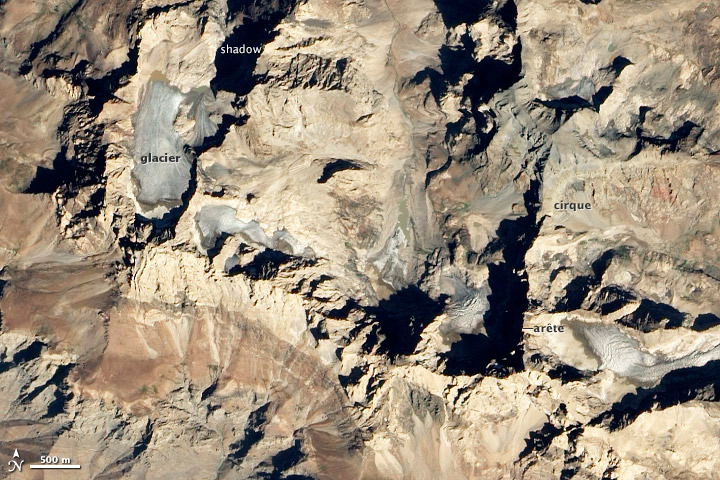
Congratulations to Britton, Dakota Steve, Alev Akyildiz, and Eric Jeffrey for being the first readers to solve the October puzzler. We posted the image on Tuesday afternoon, and by Wednesday morning Britton had worked out that the location was Mount Uludoruk in the southeastern Taurus Mountains. Later on, Dakota Steve added that it must have been taken in the fall, Alex Akyildiz was the first to give the exact coordinates, and Eric Jeffrey added some interesting details about glacial recession.
Many thanks to Mehmet Akif Sarikaya of Fatih University for providing some of the information that went into the caption we published as our Image of the Day for October 13. Among other things, Sarikaya pointed us to a fascinating account that a British solider (Major F.R. Maunsell) read to members of the Royal Geographical Society after a trip to the region. The account was published in August 1901 by the Geographical Journal. In addition to Maunsell’s colorful writing, the article included the first known image of one of Uludoruk’s glaciers.
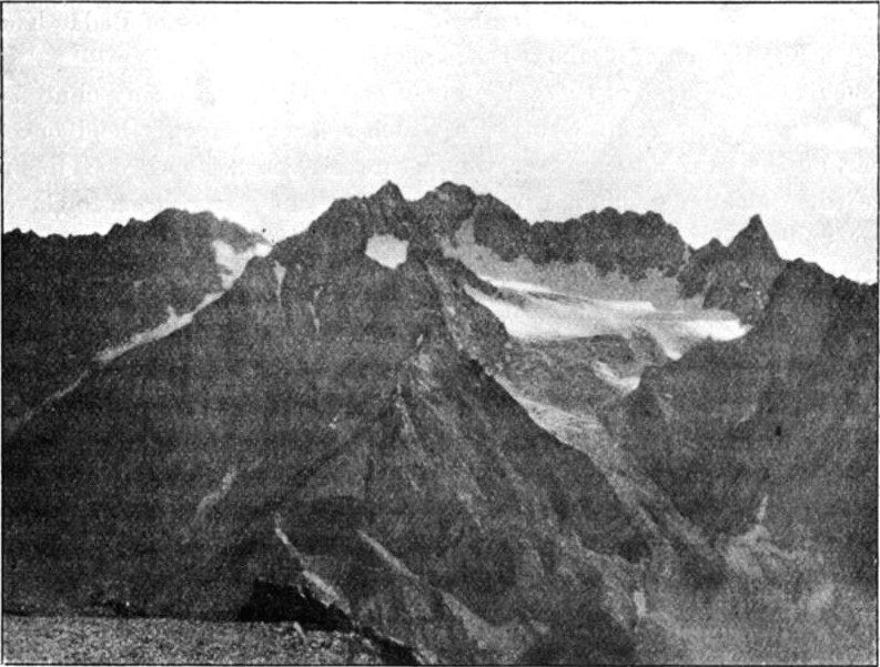
Here are a few excerpts from Maunsell’s description of the topography near the site of his photograph:
…A little south of the main ridge of Geliashin, and forming part of the group, are two masses of rock, one the Tura Dauil (David’s mountain), and facing it across a deep chasm-like valley, the other called Nakhira Shirka, both rising to about 11,000 feet. The north slopes of Geliashin and Suppa Durek are perhaps the grandest, as the ground falls away in a splendid succession of crags and precipices into the head of the valley of Des or Deezan, and the stream-level of the Great Zab, only 12 miles off, but 9270 feet lower. Below the crest a small glacier nestles under Geliashin on the north, giving rise to the Des stream, called in Turkish the Kar Su, or Snow water, and in Syriac, Mia Khwara, or White water…
…On all sides, except a narrow ridge on the south-east, are sheer precipices of several hundred feet, and after three attempts, in each of which I was brought up against lines of huge cliffs, I finally discovered that a steep path to the summit existed on the south-east side, but it was too late then to attempt it. The only guides procurable were very misleading, making any statement, if they thought it would please, and were very difficult to verify. The summit ridges swarm with ibex and moufflon, and many of the giant partridge were also seen. Judging from Galianu, the summit of Geliashin must be at least 1500 feet higher, or 13,500 feet above sea-level…
…From Geliashin a razor-edged ridge of limestone rock runs nearly due west for a few miles, and terminates in a very sharp-pointed peak known as the Suppa Durek, or Lady’s Finger (mentioned by Layard), a prominent landmark in the confused outline of crag and. pinnacle west of Geliashin. A col which gives access by a stair-like path from the Zab valley into Jelu district now intervenes to the west, beyond which runs a rugged watershed range of lesser elevation, but containing the sharp peak of Khisara, quite inaccessible except by the wild goats,and enclosing the rocky gorges of Kiyu and IUri draining to the Zab, and overlooking Jelu and Baz to the south.