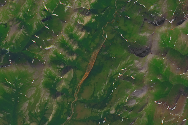
Update on January 23, 2023: This image shows Tukpahlearik Creek in northwest Alaska. Congratulations to Luis Martinez for being the first to correctly identify the feature and its location. Special mention to Steve, who provided a reason for the creek’s unusual color. Read more about the image in our Image of the Day story, which describes several hypotheses for the creek’s orange hue.
Every month on Earth Matters, we offer a puzzling satellite image. The January 2024 puzzler is shown above. Your challenge is to use the comments section to tell us where it is, what we are looking at, and why it is interesting.
How to answer. You can use a few words or several paragraphs. You might simply tell us the location, or you can dig deeper and offer details about what satellite and instrument produced the image, what spectral bands were used to create it, or what is compelling about some obscure feature. If you think something is interesting or noteworthy, tell us about it.
The prize. We cannot offer prize money or a trip on the International Space Station, but we can promise you credit and glory. Well, maybe just credit. Within a week after a puzzler image appears on this blog, we will post an annotated and captioned version as our Image of the Day. After we post the answer, we will acknowledge the first person to correctly identify the image at the bottom of this blog post. We also may recognize readers who offer the most interesting tidbits of information. Please include your preferred name or alias with your comment. If you work for or attend an institution that you would like to recognize, please mention that as well.
Recent winners. If you have won the puzzler in the past few months, or if you work in geospatial imaging, please hold your answer for at least a day to give less experienced readers a chance.
Releasing comments. Savvy readers have solved some puzzlers after a few minutes. To give more people a chance, we may wait 24 to 48 hours before posting comments. Good luck!


This looks like it could be up in the area near Ivvaik National Park in northern Yukon, Canada. A false color image.
This looks like a false color image somewhere up in the area near Ivvaik National Park in northern Yukon, Canada
My guess: Island of Hawaii with a lava-flow river.
Angola, Bicuar National Park
It’s in water.
Es la cima de Peña Rueba, cerca de rodellar, Aragón España. Es una ruta para hace una caminata de más o menos 22 km.
The river in the centre of the image has come in contact with ironstone resulting in the orange brown colour.
Divergent setting, basalt flood plain, I’m guessing Iceland.
When I was in math class, our teacher showed us the image that was taken from a satellite, and while discussing the image with my classmate, he proceeded to tell me that ” rivers aren’t orange”.. I then tried to show him that rivers can indeed be orange due to external factors, and the first thought that came to my mind was Tukpahlearik Creek in northwestern Alaska’s Brooks Range.. I looked at the image that was provided by Taylor Roades that provided the photo of Tukpahlearik Creek, and I looked at the image of this January Puzzler and they looked the same! So here I am submitting my guess.
Snow on the side of a large volcano with muddy river. Suspect Mt St Helens
In Alaska, streams are turning orange as permafrost thaws
I second the idea, that the image is underwater. I can’t offer a specific location, other than somewhere in the southern pacific!