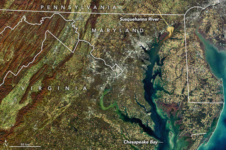
In November 2019, we highlighted this Landsat 8 image showing a glut of sediment flowing down the Susquehanna River into Chesapeake Bay. It was a striking, timely image, but one of the realities of publishing new content every day is that sometimes good information comes in after a deadline has passed.
In this case, Mark Trice, a water quality expert with the Maryland Department of Natural Resources, pointed out a few things about Susquehanna sediment after our story was out that seem worth passing on.

Among them: a link to a recent report that synthesizes and summarizes what scientists have learned about the ecological effects of high sediment flows on the Susquehanna River and the role of the Conowingo Dam. While the dam trapped most sediment and associated nutrient pollution (nitrogen and phosphorus) when it was first built, enough material has piled up behind the dam now that significant amounts of sediment and nutrients now flow past it during storms. A University of Maryland press release summarized the findings this way:
Most sediment and particulate nutrient impacts to the Bay occur during high-flow events, such as during major storms, which occur less than 10 percent of the time. Loads delivered to the upper Chesapeake Bay during low flows have decreased since the late 1970s, while loads during large storm events have increased. Most of these materials are retained within the upper Bay but some can be transported to the mid-Bay during major storm events, where their nutrients could become bioavailable.
The potential impact of reservoir sediments to Bay water quality are limited due to the low reactivity of scoured material, which decreases the impact of total nutrient loading even in extreme storms. Most of this material would deposit in the low salinity waters of the upper Bay, where rates of nitrogen and phosphorus release from sediments into the water are low.
“While storm events can have major short-term impacts, the Bay is actually really resilient, which is remarkable,” said the study’s lead author Cindy Palinkas, associate professor at the University of Maryland Center for Environmental Science. “If we are doing all of the right things, it can handle the occasional big input of sediment.”
Trice’s colleagues at the Maryland Department of Natural Resources (DNR) underscored the Bay’s resiliency to sediment as well when I asked about the recent event. “Although these high flow events routinely occur, the Bay is resilient and continues to show improvement due to the commitment by the Bay watershed partners to have all pollution reduction strategies implemented by 2025 to have a healthy Chesapeake Bay,” said Bruce Michael of Maryland DNR.
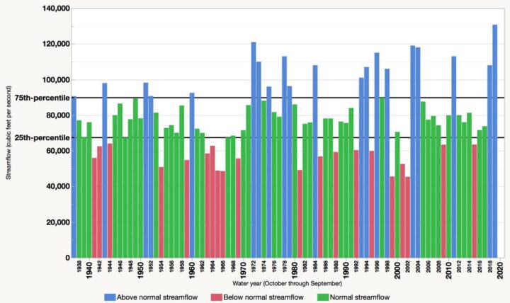
Also worth mentioning: the 2019 water year (October 1, 2018, to September 30, 2019) brought a record-breaking flow of freshwater into the Bay, Trice noted. “The annual average freshwater flow into the Chesapeake Bay during water year 2019 was 130,750 cubic feet per second, which is the highest annual amount since 1937, the first year for which data are available,” the U.S Geological Survey said.

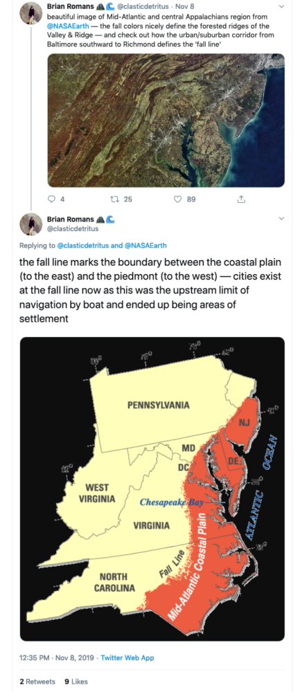
Finally, thank you to Virginia Tech geology professor Brian Romans (@clasticdetritus) for pointing out something about the image that is unrelated to sediment but fascinating: the line of cities and suburbs running from Baltimore, Md., to Richmond, Va., marks the boundary between two key geologic zones: the flat Coastal Plain to the east and the more rugged Piedmont to the west. Interestingly, many cities are located along this “fall line” because rapids prevented boats from traveling any farther upstream when they were first settled.

Tags: Chesapeake Bay, water


