
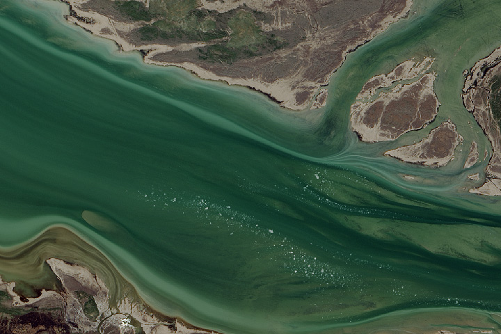
Every month on Earth Matters, we offer a puzzling satellite image. The November 2015 puzzler is above. Your challenge is to use the comments section to tell us what part of the world we are looking at, when the image was acquired, what the image shows, and why the scene is interesting.
How to answer. Your answer can be a few words or several paragraphs. (Try to keep it shorter than 200 words). You might simply tell us what part of the world an image shows. Or you can dig deeper and explain what satellite and instrument produced the image, what spectral bands were used to create it, or what is compelling about some obscure speck in the far corner of an image. If you think something is interesting or noteworthy, tell us about it.
The prize. We can’t offer prize money, but, we can promise you credit and glory (well, maybe just credit). Roughly one week after a puzzler image appears on this blog, we will post an annotated and captioned version as our Image of the Day. In the credits, we’ll acknowledge the person who was first to correctly ID the image. We’ll also recognize people who offer the most interesting tidbits of information about the geological, meteorological, or human processes that have played a role in molding the landscape. Please include your preferred name or alias with your comment. If you work for or attend an institution that you want us to recognize, please mention that as well.
Recent winners. If you’ve won the puzzler in the last few months or work in geospatial imaging, please sit on your hands for at least a day to give others a chance to play.
Releasing Comments. Savvy readers have solved some of our puzzlers after only a few minutes or hours. To give more people a chance to play, we may wait between 24-48 hours before posting the answers we receive in the comment thread.
Good luck!
I am going to say that it appears to have mountain run off so I am placing it in northern B.C. the Skeena River.
Skeena River -Northern B.C.
I thing this rever but much difficult image
At first I thought it was some river, but now I think it to be somewhere in a cave.
It’s a picture of a cave ‘wall’
Why it’s special is that is allows you to see how this was made because of the rings a trails left from mineral deposits as water trickled over that area forming to structure over billions of years.
Or maybe I’m a moron.
Yukon / Kuskokwin delta area – Alaska
This skeena river
I think the image is on the Southern Hemisphere, maybe Southern Chile. There are some small icebergs coming from a glaciar from the East. But I need a couple of hours more to check it better
Ganges Delta?
From the appearance of the water, the relief forms and the tundra-like vegetation patterns, this is a braided or anastomosing river in a subarctic region. The flow direction is from East to West as can be seen by the sediment flumes where the smaller river channel coming from the North joins the main river. There are bits of floating ice drifting in the river – as the river itself is not frozen and the ice must have formed under conditions of calmer water, this suggests the presence of a lake somewhere to the East of the image. As this is a NASA puzzle, the image resolution is most probably not higher than 30 m (Landsat), so we have a large river here, and correspondingly we are looking for a large lake.
After getting this far with my puzzling, I decided do have a look at some of the great lakes in Canada and was lucky in finding the spot rather quickly: the images shows a part of the Mackenzie River close to where it leaves the Great Slaves Lake in Canada’s Northwest Territories. It could be a Landsat 8 image taken most probably in June or July, as this is usually the time of the year the Great Slave Lake ice cover breaks up.
Delta Nile river in Mediterranean sea ?
It is Mackenzie river in the Northwest Territories with its sandbars and Tundra vegetation on the shores, approx. 20 miles after leaving the Great Slave Lake.
In the bottom left a small part of the Kakisa river delta can be seen.
The river is transporting some ice floe. The green colour is due to algal growth in summer.