
Each month, Earth Observatory offers up a puzzling satellite image here on Earth Matters. The November 2013 puzzler is above. Your challenge is to use the comments section to tell us what part of the world we are looking at, when the image was acquired, and why the scene is interesting.
How to answer. Your answer can be a few words or several paragraphs. (Try to keep it shorter than 300 words). You might simply tell us what part of the world an image shows. Or you can dig deeper and explain what satellite and instrument produced the image, what spectral bands were used to create it, or what is compelling about some obscure speck in the far corner of an image. If you think something is interesting or noteworthy, tell us about it.
The prize. We can’t offer prize money for being the first to respond or for digging up the most interesting kernels of information. But, we can promise you credit and glory (well, maybe just credit). Roughly one week after a puzzler image appears on this blog, we will post an annotated and captioned version as our Image of the Day. In the credits, we’ll acknowledge the person who was first to correctly ID the image. We’ll also recognize people who offer the most interesting tidbits of information. Please include your preferred name or alias with your comment. If you work for an institution that you want us to recognize, please mention that as well.
Recent winners. If you’ve won the puzzler in the last few months, please sit on your hands for at least a few days to give others a chance to play.
Releasing Comments. Savvy readers have solved many of our puzzlers after only a few minutes or hours. To give more people a chance to play, we’re going to wait between 24-48 hours before posting the answers we receive in the comment thread this time.
This picture is one of the best ever made of the amazing country wich is made true our God thrue our Lord Jezus
I’m going to guess somewhere in northern Canada, like northeastern Nunavut. It looks like it would be pretty close to a true-color image of lakes in the highly carved (faults and glacial) terrain. And, because it’s a great sensor, I’m going to guess that it’s an image produced using data from Landsat 8’s OLI.
Allen Pope
National Snow & Ice Data Center
@PopePolar
Land I lakes minnisota
Northern Quebec east of Hudson Bay?
a karstifed carbonate plateform
I’m going to guess this is Western Greenland, and that the image was acquired sometime over the summer, and that the reason it is interesting is because it was completely ice and snow free for the first time.
no idea but my guess would be a mid-summer photo of the Canadian far north, maybe around Baffin Island….looks like a million little rocky islands surrounded by the Sea/ocean..
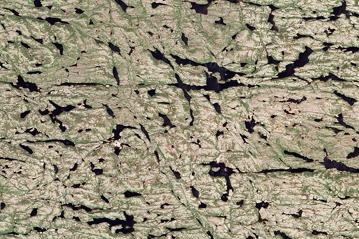
It’s an expanse of the forest-tundra vegetation zone on the Canadian Shield. Whitish areas are lichen-tundra vegetation on hilltops and upper slopes and green areas are shrubs or forest stands in the lowlands.
I believe this is a picture somewhere in Finland. (The land of thousand lakes)
My guess is the leaves on the top of a Forrest canopy.
Northwest Territories of Canada, near Great Slave Lake. Lots of mining in the area, Canadian Shield rocks, some of the oldest in the world!
This looks like the Mackenzie, Northwest Territory, Canada, near the Great Slave Lake, perhaps Clinton-Colden Lake
I was really challenged to find the exact center coordinates of the scene as the place should be somewhere in the Canadian Shield. Why it should be there, because of the few notable landscape features such as: 1) drumlins and post-glacial lakes (the post-glacial lakes and the scale of the glaciation which was in the entire scene told us that there was a continental glacier before. There are not much places on Earth which feature Pleistocene continental glaciation so this must be either Scandinavian or Canadian Shield. However by comparing both by lake patterns and the visible lineaments as well as the lavish vegetation of the latter only the Canadian Shield left. 2) the geology is strikingly even and compact (though the faults cross the scene in parallel and sub-meridional directions) – which again means that we have a shield as a background geology. I hope I am close, though finding a needle in a pile of hay is not that easy (I mean the exact place with its coordinates) :)))
This seems to be a portion of Greenland most recently denuded of ice.
A few of the many small lakes of Newfoundland or Northern Quebec
My guess is the Greenland continental glacer
It looks like Arctic Canada or the North Slope of Alaska
Coast near Murmansk.
Nunavut
Gosh, looks like a recently glaciated terrain, but with ancient shield rock structure underneath, much faulting (all highly interesting). Probably a high-latitude image. Picture taken in the late summer (no snow or ice). So could be any of the following:
(a) Canadian Arctic or similar
(c) Isle of Lewis (NW Scotland) or northern Scandinavia
(d) A high altitude karstic landscape from a lower latitude (e.g. Balkans of Europe)
Well, I suppose I have to guess which one?
Let’s say (c)!
E.G., 21/11/2013
It’s the Canadian Shield, taken during the summertime. It’s of interest because it clearly shows the immature hydrological drainage pattern due to the system still recovering from the last glaciation.
Just south of Ungava Bay near the borderr of Quebec and Labrdor. The landscape is interesting because of the way lakes have been formed by the striations caused by glaciers scraping the bedrock and the different directions they moved.
Just south of the carboniferous era asteroid strikes in Canada. About 56N 74W. Not sure if the strike caused fracturing still visible today. I thought this was somewhere on Canadian Shield but could not locate it until I saw the recent posting about the asteroid strikes.
new quebec
nw Quebec
The stone, it looks like granite. In the past land-ice rather than a glacier had scraped over it. Remarkebly is that the grooves run horizontally here, and a few crossing SE- NW. In almost all places along the Canadian shield, in Scotland and in Scandinavia and West Russia the scrapes run more or less S-N. The post-glacier lakes have edges defined by the grooves, which is more irregular than in for example Siberian glacier lakes. The picture is made in summer, the lakes look like filled with water and not with ice, no snowrims visible and there is a faint green blush from (tundra) vegetation. Remarkebly too is the absence of rivers. Only two places I found where the earth looks like this are in Nunavut west of Southampton Island and in the region east of Murmansk near the Russian-Norwegian border. But neither place I could find the exact spot 🙁 Thanks for this interesting puzzler, I even ‘visited’ Antarctica and Cape Horn.
Whatever happened to the answer for November 2013? I have been searching carefully and can’t find the post!