 | |||
|
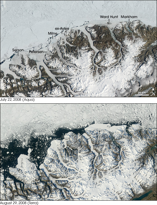
In 1907, Arctic explorer Robert Peary traveled along the northern coast of Canada’s Ellesmere Island on a dog sled and described a “glacial fringe” along the island’s northern coast. Modern glaciologists have deduced that this ice fringe formed roughly 4,500 years ago and, in Peary’s time, was likely a continuous ice shelf covering some 8,900 square kilometers (almost 3,500 square miles). By the 1950s, much of that ice had disintegrated. By July 2008, what had once been a massive ice fringe along the northern Ellesmere coast had been reduced to five isolated ice shelves: Serson, Petersen, Milne, Ward Hunt, and Markham. (The Ayles Ice Shelf broke free in 2005.) These five ice shelves constituted the last remaining ice shelves in Canada. On July 22, 2008, a new wave of ice shelf disintegration began and, by late August, these ice shelves had lost a total of 214 square kilometers (83 square miles). A group of researchers led by Derek Mueller at Trent University, and Luke Copland at the University of Ottawa, announced the changes in early September 2008. The Ward Hunt Ice Shelf lost a total of 42 square kilometers (16 square miles). The Serson Ice Shelf lost 122 square kilometers (47 square miles)—60 percent of its previous area. The Markham Ice Shelf, with a total area of 50 square kilometers (19 square miles) completely broke away from the Ellesmere coast. |
|||
 | |||
Ward Hunt Ice ShelfWhen the Ward Hunt Ice Shelf began to disintegrate on July 22, 2008, it provided an unexpected demonstration of environmental change. Luc Hardy, a venture capitalist who volunteers for Green Cross—an organization emphasizing the relationship between peace, prosperity, and environmental health—had taken a group of young explorers on a trip to the Ward Hunt Ice Shelf. Before embarking on this trip, Hardy had touched base with Mueller for pointers on interesting places to visit. The group was lunching on the shelf on July 22 when they noticed a island of ice floating out to sea. |
Between July 22 (top) and August 29 (bottom), 2008, the five ice shelves remaining in the Canadian Arctic experienced major losses. These images of the Northern coast of Ellesmere Island were made by the Moderate Resolution Imaging Spectroradiometer (MODIS) on NASA’s Terra and Aqua satellites. (NASA images by Jesse Allen.)
| ||
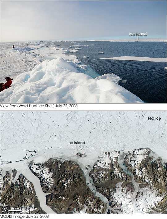 | |||
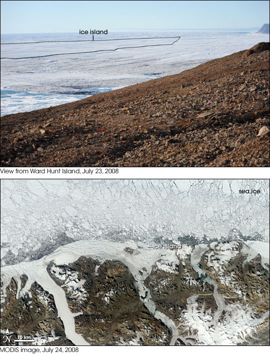
In a telephone conversation with Mueller soon afterwards, Hardy learned that the events transpiring on the shelf—while his group was there—were big enough to appear in satellite imagery. “That’s when we understood that we witnessed a major story but did not know it at the time we were having a casual lunch,” Hardy says. After lunch, the explorers returned to camp. In the wee hours of the morning on July 23, 2008, Hardy climbed a hill on Ward Hunt Island, not far from the edge of the Ward Hunt Ice Shelf. Looking toward the northeast, he took another photograph of the shelf. The picture captured a loose slab of ice that, the following day, also floated away. |
On July 22, 2008, Luc Hardy stood on the Ward Hunt Ice Shelf and photographed an ice island floating away (top). Later, he and Derek Mueller identified the ice island in satellite imagery (bottom) from the MODIS sensor on NASA’s Aqua satellite. (Photograph © 2008 Luc Hardy / SAGAX. All rights reserved. NASA MODIS image by Jesse Allen.) Large image (988 KB JPEG) | ||
 | |||
Although he couldn’t have predicted that a major break up would occur during Hardy’s visit to the Ward Hunt Ice Shelf, Mueller had good reason to suspect something interesting would happen sometime this season. Currently on a fellowship in Northern and Polar Studies at Trent University, Mueller had made his own significant discovery on that shelf several years earlier. In 2002, while pursuing his Ph.D., he found that the ice shelf had split into eastern and western halves. The event also drained a freshwater lake that had been home to a unique microbial ecosystem. In April 2008, Mueller was back on Ellesmere. Flying over the Ward Hunt Ice Shelf, he saw what he suspected were new cracks. He wasn’t able to visit the shelf personally, but asked reservists in the Canadian military for help in mapping new fissures. “They took GPS [global positioning system] measurements up and down the cracks,” he recalls. “The cracks were actually ‘beyond count.’ They couldn’t measure them all, they told me.” Markham Ice ShelfAfter the Ward Hunt Ice Shelf calved ice islands in July 2008, the Ellesmere coast continued losing ice. Luke Copland, director of the Laboratory for Cryospheric Research at the University of Ottawa, worked with Mueller in studying the Ellesmere coast. Previously, Copland had studied the breakup of the Ayles Ice Shelf, but even having witnessed the loss of that ice shelf, he was taken aback by the rapid changes in August 2008. “We were flipping through the satellite images of the Markham Ice Shelf,” he recalls. “The whole ice shelf was there on August 7. On August 12, it was gone. It was just an empty fjord with no ice in it.” |
Hardy’s July 23 photograph (top) shows a crack (outline added) in the Ward Hunt Ice Shelf. The crack produced a second ice island that was visible in an image acquired by the MODIS on NASA’s Terra satellite on July 24, 2008. (Photograph © 2008 Luc Hardy / SAGAX. All rights reserved. NASA MODIS image by Jesse Allen.) Large image (496 KB JPEG) | ||
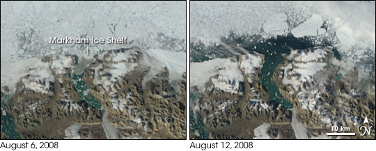 | |||
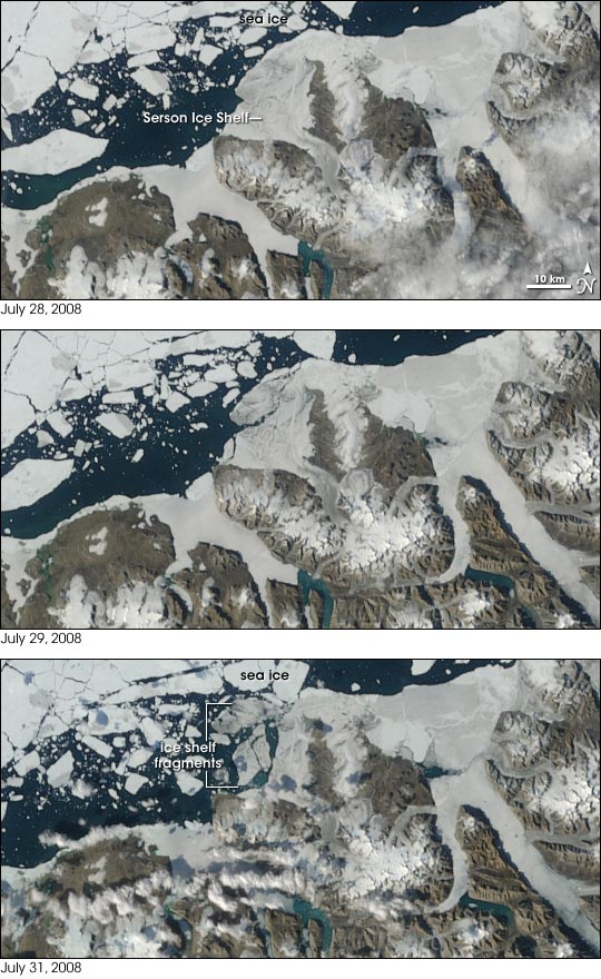
“The Markham is about 50 square kilometers. For comparison, Manhattan is about 60 square kilometers,” Copland explains. “This event was a big surprise because it was a really big ice shelf.” Serson Ice ShelfThe largest ice shelf retreat in the Northern Hemisphere summer of 2008 occurred on the Serson Ice Shelf. Between July 29 and July 31, 2008, this ice shelf shrank by 60 percent, losing 122 square kilometers. |
The Markham Ice Shelf completely disintegrated between August 6, 2008 (left), and August 12, 2008 (right). These images were captured by MODIS on NASA’s Terra satellite. (NASA MODIS images by Jesse Allen.)
| ||
 | |||
The breakup of the Ward Hunt Ice Shelf in 2002 caused an epishelf lake—a freshwater lake resting atop denser seawater—to drain, taking with it a unique microbial ecosystem that scientists had only begun to study. The disintegration in July 2008 of a large chunk of the Serson Ice Shelf threatened another microbial community with a similar fate, as this ice shelf dams a shallow freshwater lake. Complex CausesAided by eyewitness accounts and satellite imagery, changes in the shelf’s extent are fairly easy to recognize. Understanding the underlying causes is more complicated. On the Antarctic Peninsula, for instance, melt water ponds have been identified as a factor in ice shelf demise. But melt water ponds have long been present on the Ellesmere Island ice shelves. So much water covered the coast’s ice when Peary was exploring the area 100 years ago, that he likened the shelf to “a gigantic potato field with a long blue lake or rushing stream in every furrow.” When Mueller looked at satellite imagery of the Ward Hunt Ice Shelf acquired early in 2008, he saw that the ice shelf was cracked but still in place “fitting in like pieces of a jigsaw puzzle—interlocking.” But he realized that the right conditions could change the situation. “If the sea ice is up against the ice shelf, there’s really no room for a piece of ice shelf to come out of that jigsaw puzzle and float away. But that’s what happened in July when we had open water in front of the ice shelf.” Besides retreating sea ice, Ted Scambos, lead scientist at the National Snow and Ice Data Center, thinks warmer waters could play a role. Due to its light color, sea ice reflects much of the Sun’s energy out to space, but dark ocean water absorbs heat. Heat-absorbing, dark water causes sea ice to retreat even more. “As sea ice retreats, the exposed water in front of the shelf warms,” he explains. “And as the ice in the fjord behind the shelf retreats, that water is also warmed. It’s possible that warmer water is circulating under the shelf and causing basal melting.” |
The Serson Ice Shelf retreated dramatically in just a few days in late July 2008. The MODIS sensor on NASA’s Terra satellite captured these images on July 28 (top), July 29 (middle), and July 31 (bottom). The ice shelf appears in the middle of the images. Although the ice shelf appears intact on July 28, it fractured by July 29, and large portions started floating away on July 31. (NASA MODIS images by Jesse Allen.)
| ||
 | |||
Warmer air temperatures on the Ellesmere coast are definitely part of the picture, too, says Copland. When studying the disintegration of the Ayles Ice Shelf in 2005, Copland and his collaborators used climate models to study temperature changes over the past five decades. “What we see is that in the summer, it’s warmed by about 2 degrees Celsius over the last 50 years. But what’s really dramatic is that it’s warmed a lot in the winter, by about 5 degrees Celsius,” he says. “Part of it [the explanation for the ice shelf loss] is the summer story, but a lot of it is really the winter story, the fact that it’s not as cold in the winter anymore. So the ice shelves don’t have that intense cold to really recover from having been broken apart in the summer.” Whatever the complicated mechanisms underlying ice shelves’ retreat, Mueller laments their future. “Something like 90 percent of the ice shelves along the Ellesmere coast have gone away. With a shelf like the Ward Hunt, you’re looking at one of the last of its kind.”
|
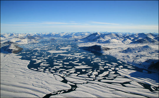
Ice shards from the Ward Hunt Ice Shelf float into Disraeli Fjord in August 2008. Rising water temperatures at sea and in the fjords behind the ice shelves may contribute to ice shelf break up. (Photo courtesy Denis Sarrazin, ArcticNet/Centre d’Etudes Nordiques.) | ||
