 |
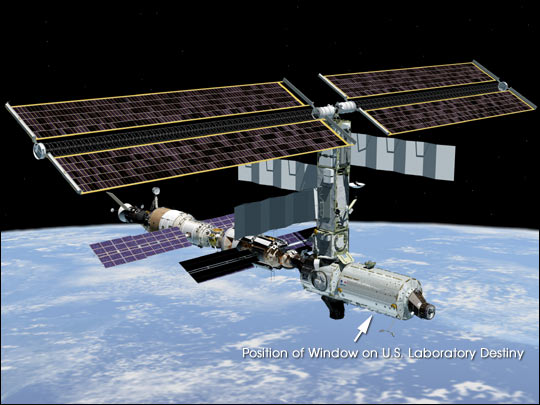
With much of their time committed to constructing the International Space Station, astronauts and cosmonauts are also beginning their first scientific studies. The Destiny Laboratory just joined to the International Space Station includes the best optical quality window ever flown on a human-occupied spacecraft. The window will eventually host a number of remote sensing experiments mounted on a special rack system, the Window Observational Research Facility or WORF, for mechanical and electrical support (Eppler et al. 1996). Until the WORF is complete in June 2002, astronauts are photographing the Earth’s surface as part of an early project, called Crew Earth Observations. |
|||
|
|||
Since early space missions in the 1960s, astronauts have photographed
the Earth below–observing the world’s geography and
documenting transient events like storms, floods, fires, and volcanic
eruptions. The early photography formed a foundation for Landsat and
other Earth observing satellites (Lowman 1999). Even as such satellites
have become the most common way for scientists to collect data from
orbit, humans have continued to look out the windows of spacecraft and
to record what they see with cameras. For the early Space Station
expeditions, astronauts will use 70- and 35-mm film cameras and
electronic still cameras to capture images of the Earth. |
Artist's rendering of the International Space Station (ISS) after installation of the U.S. Laboratory Destiny and its nadir-viewing optical quality window during Space Shuttle Mission STS-98/Station Mission 5A in February 2001 (Image JSC2001e00360 | ||
Astronauts’ photos document human impacts on the Earth–such as city growth, agricultural expansion, and reservoir construction. Today, images of the world spanning more than 30 years provide valuable insight into Earth processes and the effects of human activities on the planet. Photographic images taken by astronauts serve as both primary data on the state of the Earth and as secondary data to be combined with images from other satellites in orbit. Through their photography of the Earth, International Space Station astronauts will build on the time series of imagery started 35 years ago, ensuring that this continuous record of Earth remains unbroken. As a formal project or "payload" on the International Space Station, Crew Earth Observations will focus on some of the most dramatic examples of change on the Earth’s surface. An interdisciplinary group of scientists selected some of the most dynamic regions of the Earth as their initial target sites that could be observed under the tight time constraints of the early phases of Space Station construction. These sites include major deltas in south and east Asia, coral reefs, major cities, smog over industrial regions, areas that typically experience floods or droughts triggered by El Niño cycles, alpine glaciers, tectonic structures, and features on Earth, such as impact craters, that are analogs to structures on other planets. Julie A. Robinson and Cindy Evans are scientists in the Earth Sciences and Image Analysis Laboratory at Johnson Space Center. The laboratory manages and coordinates all astronaut photography of Earth, including the Crew Earth Observations Payload. Access to astronaut photography of Earth is through the Gateway to Astronaut Photography at http://eol.jsc.nasa.gov /sseop/ The data used in this study are available in one or more of NASA's Earth Science Data Centers. |
| ||