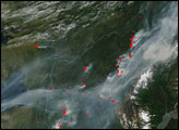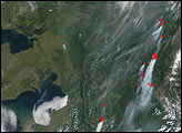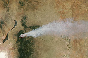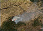
Unusually hot and dry for this time of year, Alaska is experiencing several large, intense wildfires as a result. This image from the Moderate Resolution Imaging Spectroradiometer (MODIS) from May 26, 2002, shows heavy smoke choking the air for several hundred miles around Fairbanks. Though hidden by smoke in this image, Fairbanks is located just to the south of (and centered roughly between) the two large clusters of fires (red dots) at upper right.
The westernmost fire of that pair is being called the MP 78 Elliott Highway Fire, and it is currently 35, 000 acres. A wind event on May 27 caused spreading, and the fire is currently burning in vegetation that normally acts a natural barrier to fire spread. Though some structures have been threatened, none have yet been destroyed.To the east, fire fighters are battling the flames of the West Fork Chena Fire. Numerous structures are threatened in this tourist area, and the fire has spread to over 14, 000 acres.
To the southwest, the Vinasale Fire (southernmost fire) is already 20,000 acres and the entire fire perimeter is active, meaning the fire is 0% contained. So far this year, Alaska has experienced 219 wildfires, which have burned more than 125,000 acres.Please note that the high-resolution scene provided here is 500 meters per pixel. For a copy of this scene at the sensor's fullest resolution, visit the MODIS Rapidfire site.
Image courtesy Jacques Descloitres, MODIS Land Rapid Response Team at NASA GSFC