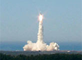
The majority of Earth science research satellites developed or operated by NASA in the past few decades have been launched from Vandenberg Air Force Base. The newest satellite in the venerable Landsat program launched from this spot along the central California coast on February 11, 2013, following the path of its seven predecessors. The Landsat Data Continuity Mission (LDCM) is extending and expanding a 41-year record of land observations of the United States and of every continent.
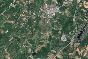
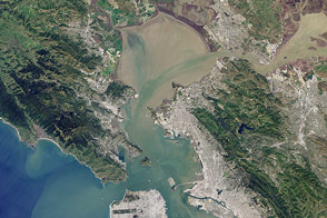
The Operational Land Imager (OLI) on LDCM captured these views of its launch site, the nearby city of Lompoc, and the surrounding landscape on March 22, 2013. The two inset images were made from the top image, as the OLI can resolve surface features down to a scale of 15 meters per pixel. All of the images are considered engineering data, helping scientists and engineers ensure that the satellite and its instruments are operating as designed. The satellite is not expected to be completely operational until early summer, when control is officially handed off from NASA to the U.S. Geological Survey.
Vandenberg is NASA’s preferred launch site for satellites that are headed into polar orbits. The Air Force base sits on a parcel of land that juts out into the Pacific Ocean, allowing rockets to launch to the south without flying over populated areas. (Satellites that are headed into a west-east orbit are typically launched from Kennedy Space Center.) LDCM lifted off from Space Launch Complex 3 East (SLC-3E), visible in the middle image. To the west, SLC-4W was the site of more than 90 rocket launches from 1963 to 2003. Note that the scene is clear and resolved enough to show ocean waves offshore.
Beyond the military reservation, a Mediterranean climate supports oak and other hardwood trees, sagebrush, and coastal prairie-scrub grasses, while Lompoc boasts extensive vegetable and seed-flower farms. To the southeast, Rufugio State Beach sits on protected public land that is popular with campers. The LDCM imager is sensitive enough to detect the underwater kelp forests growing offshore, west of Refugio.

The OLI instrument is designed to observe Earth’s surface in the visible, near infrared, and short-wave infrared portions of the spectrum. Its images have 15-meter (49 foot) panchromatic and 30-meter multi-spectral spatial resolutions along a 185 km (115 miles) wide swath. OLI can take measurements in two new spectral bands: one to observe high-altitude cirrus clouds and another to observe atmospheric aerosols, as well as water quality in lakes and shallow coastal waters. The entire surface of Earth will fall within LDCM’s view once every 16 days.
Read more about LDCM’s birthplaces—the locations in the United States where Landsat missions have been conceived, built, and controlled—by clicking here.
Images by Robert Simmon, using data from the U.S. Geological Survey and NASA. Caption by Mike Carlowicz and Holli Riebeek.


