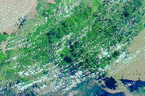
Monsoon floods struck Pakistan’s southern Sindh Province in August 2011. A drain breach in Badin District left residents marooned on dry spots separated by high water, GulfNews.com reported.
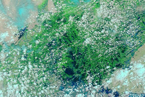
The Moderate Resolution Imaging Spectroradiometer (MODIS) on NASA’s Terra satellite captured these images on August 16, 2011 (top), and July 17, 2011 (bottom). The images show southern Pakistan, near the coast and near the border with India.
Both images use a combination of visible and infrared light to increase contrast between water and land. Water ranges in color from electric blue to navy. Vegetation is green, and bare ground is pink-beige. Clouds are pale blue-green.
Pakistan typically receives most of its moisture between July and September. Despite some cloud cover, these images, acquired one month apart, show significant changes to the landscape. In mid-August, flood water sits on areas that had been dry a month earlier. Although conditions remain relatively dry around the city of Hyderabad, flooding is obvious around the city of Badin.
The flooding in southern Pakistan affected 100 villages and more than 200,000 people, according to news reports. Pakistan’s prime minister declared parts of the region disaster areas and pledged thousands of tents to provide temporary shelter.
Just over the Indian border lies the Rann of Kachchh (or Kutch). Annual rains change this area from salt desert to salt marsh, and the increase in standing water has colored this region bright blue by mid-August.
NASA images courtesy MODIS Rapid Response Team, Goddard Space Flight Center. Caption by Michon Scott.