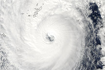
On October 28, 2010, Typhoon Chaba continued raging over the Philippine Sea, its clouds extending over Japan’s Ryukyu Islands, including Okinawa. According to Unisys Weather, Chaba had winds of 115 knots (210 kilometers per hour) at 3:00 p.m. Tokyo time (6:00 UTC) on October 28. At 1:40 p.m. Tokyo time (4:40 UTC), the Moderate Resolution Imaging Spectroradiometer (MODIS) on NASA’s Aqua satellite captured this natural-color image. The storm spans hundreds of kilometers, completely covering Okinawa and nearby islands.
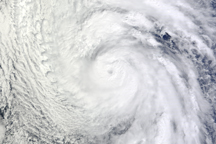
At 15:00 UTC on October 29 (midnight on October 30 Tokyo time), the U.S. Navy’s Joint Typhoon Warning Center reported that Chaba’s winds had diminished from the previous day’s levels, but remained strong. Chaba had maximum sustained winds of 80 knots (150 kilometers per hour) with gusts up to 100 knots (185 kilometers per hour). Chaba was located roughly 460 nautical miles (850 kilometers) southwest of Yokosuka, Japan, and was moving slowly toward the northeast.
NASA image courtesy Jeff Schmaltz, MODIS Rapid Response Team at NASA GSFC. Caption by Michon Scott.