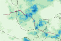
The first tropical depression in the 2010 Atlantic hurricane season formed in the western Caribbean on June 25, 2010, according to the U.S. National Hurricane Center (NHC). On June 26, Tropical Depression One became Tropical Storm Alex. By June 27, the NHC reported, Alex had weakened to a tropical depression, but was expected to re-strengthen over the Gulf of Mexico. At 10:00 a.m. Central Daylight Time on June 27, the storm had maximum sustained winds of 35 miles (55 kilometers) per hour, and was located some 85 miles (135 kilometers) south of Campeche, Mexico.
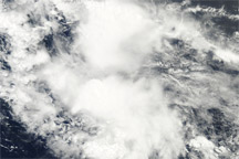
The Moderate Resolution Imaging Spectroradiometer (MODIS) on NASA’s Aqua satellite captured this true-color image of Alex on June 26, 2010. The storm hovers primarily over Guatemala, Belize, and Honduras.
NASA image by Jeff Schmaltz, MODIS Rapid Response Team at NASA GSFC. Caption by Michon Scott.