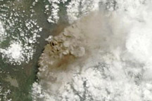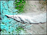
Although Ecuador’s Tungurahua volcano has been erupting ash for the past several weeks, the thick clouds of the eastern Andes obscured most of the activity. A break in the clouds enabled the Moderate Resolution Imaging Spectroradiometer (MODIS) aboard NASA’s Terra satellite to observe the eruption on January 23, 2010. As the satellite orbited overhead, a tan ash plume stretched 60 kilometers (40 miles) to the southwest of the peak.
According to the Joint Air Force & Army Weather Information Network, ash reached an altitude of 27,000 feet (8,200 meters)—more than 3,000 meters (10,000 feet) above the 5,023-meter (16,480-foot) summit. Observers from the Ecuadorian Instituto Geofísico reported lava fountains and lava blocks cascading down the flanks of the volcano, as well as loud booms and ashfall in the surrounding communities.
NASA image by Jeff Schmaltz, MODIS Rapid Response Team. Caption by Robert Simmon.