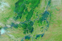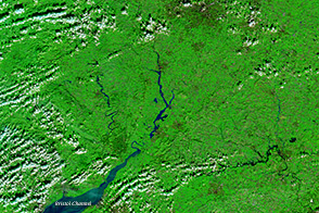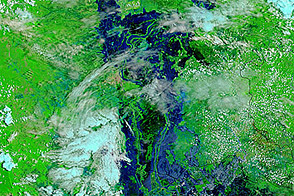
In late August and early September 2009, widespread flooding occurred throughout western North Africa along the western expanse of the Sahel. By early September, heavy rains and resulting floods killed five people and left 150,000 more homeless in Burkina Faso, The New York Times reported. In Niger, Burkina Faso’s northeastern neighbor, four days of intense rain damaged some 3,500 homes, took out electrical power lines, and caused livestock and crop losses, ReliefWeb reported.
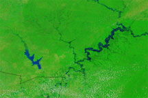
The Moderate Resolution Imaging Spectroradiometer (MODIS) on NASA’s Terra satellite captured these images of Burkina Faso. The top image is from September 3, 2009, and the bottom image is from August 28, 2009. Both images use a combination of infrared and visible light to increase the contrast between water and land. Vegetation appears bright green, clouds appear bright turquoise, and water appears electric blue. Swelling along the Nakambé River is apparent in the image from September 3. In the image from August 28, the same water channel is barely discernible. To the north, the riverbed appears nearly white, but this may result from sunglint—sunlight bouncing off the water’s surface like a mirror.
NASA image courtesy MODIS Rapid Response Team, Goddard Space Flight Center. Caption by Michon Scott.