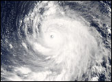
Super Typhoon Ioke started as all tropical cyclones do, as a depression—an area of low atmospheric pressure. After forming August 19, 2006, the depression quickly developed into a tropical storm, the threshold for earning a name. Storms and hurricanes in the central Pacific are unusual, but they occur often enough for there to be a naming convention, applied by the Central Pacific Hurricane Center in Honolulu. Ioke rose all the way to hurricane strength in less than 24 hours. Ioke has since also performed another unusual trick, crossing the International Date Line on August 27, which by convention means the tropical cyclone is called a typhoon instead of a hurricane. Technically, it became a super typhoon [a term used for typhoons with sustained winds over 240 kilometers per hour (150 miles per hour)] on August 24, but it retained the title of hurricane until it crossed into the typhoon region.
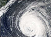
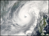
This photo-like image was acquired by the Moderate Resolution Imaging Spectroradiometer (MODIS) on the Aqua satellite on August 31, 2006, at 2:05 p.m. local time (02:05 UTC). Super Typhoon Ioke at the time of this image had a well-defined round shape, distinct spiral-arm structure, and a slightly cloud-filled (“partially closed”) eye. The University of Hawaii’s Tropical Storm Information Center reported that Super Typhoon Ioke had sustained winds of around 245 kilometers per hour (155 miles per hour) at the time this satellite image was acquired.
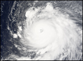
Super Typhoon Ioke may not be encountering any landmass capable of disrupting the Category 5 typhoon, but that does not mean there is no land in its way at all. Wake Island is a small atoll island with a small population serving a military and civilian base located on the island. At the time of this image, all residents had been evacuated. The storm system is starting to travel over the atoll and its predicted track will take it almost directly over the island, so the buildings will face the full strength of the strongest winds of the super typhoon. As there are no tall land features on the island, it is quite possible that storm surge from the typhoon will send water cascading over the entire island, submerging it, and only the most sturdy of structures are likely to survive the onslaught of storm surge, surf, and powerful winds, according to the Associated Press.
The high-resolution image provided above is provided at the full MODIS spatial resolution (level of detail) of 250 meters per pixel. The MODIS Rapid Response System provides this image at additional resolutions.
NASA image by Jeff Schmaltz, MODIS Rapid Response Team, Goddard Space Flight Center.