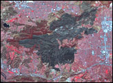
At the end of March 2006, a grassfire broke out in western Iceland, perhaps as a result of a smoldering cigarette butt. Although this area near the coast to the northwest of the country’s capital, Reykjavik, is typically very wet, a period of persistent north winds dried out the grass and made it flammable. The fire burned for several days, threatening farms and livestock and resulting in Iceland’s largest fire in its recorded history.
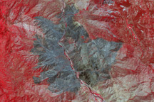
This image from the Advanced Spaceborne Thermal Emission and Reflection Radiometer (ASTER) on NASA’s Terra satellite was captured on April 6, 2006. The burned area appears as a large brownish-charcoal splotch in the center of the image. The fire started inland and burned all the way to the coast. This is a false-color image, and unburned vegetation appears red, clouds appear white, and the Atlantic Ocean (image left) appears nearly black. Several partially ice-covered lakes are scattered across the burned landscape; these lakes appear light blue.
NASA image created by Jesse Allen, Earth Observatory, using data provided courtesy of NASA/GSFC/METI/ERSDAC/JAROS, and U.S./Japan ASTER Science Team