A series of fast-moving storms brought heavy rains, flooding, and mudslides to the Pacific coast in late December 2005. According to news reports, there was one reported fatality as a result of a mudslide. Although the weather pattern in place was not quite a “Pineapple Express,” wherein the subtropical jet stream brings moisture from near Hawaii to higher latitudes, it was similar. The storms and moist air were pressed upon the mountains, wringing precipitation from the air.
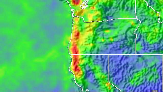
The TRMM-based, near-real-time, Multi-satellite Precipitation Analysis (MPA) rainfall totals are shown here for the period December 22-29, 2005, for the West Coast region. Rainfall totals for the period exceeded 200 millimeters (8 inches, shown in orange) all along the coastal ranges from just inland of Cape Mendocino in northern California all the way north past Mount Olympus in northwestern Washington State. Local amounts exceed 250 millimeters (red-orange areas) inland from Cape Mendocino and over Mount Olympus. The effect of the mountains on precipitation is clearly visible, as the highest totals occurred on the upwind slopes, with much less precipitation on the lee (or downwind) slopes. The train of storms was expected bring additional rains farther south across central California.
The TRMM-based, near-real-time, MPA at the NASA Goddard Space Flight Center estimates rainfall over the global tropics. TRMM is a joint mission between NASA and the Japanese space agency, JAXA.
Image produced by Hal Pierce (SSAI/NASA GSFC) and caption by Steve Lang (SSAI/NASA GSFC).