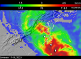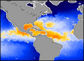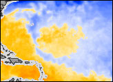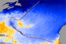
This animation shows how Hurricanes Fabian and Isabel drew their strength from warm ocean waters. As the storms moved across the Atlantic, their fierce winds and rain kicked up ocean spray, leaving a trail of cool water in their path. The water vapor was drawn into the storm. Eventually, the heat that had been in the ocean was released into the atmosphere when the water vapor condensed into rain. The added energy produced more wind, which fueled the storms further until they moved over cooler water or land.
The Advanced Microwave Scanning Radiometer (ASMR-E) on the Aqua satellite recorded sea surface temperatures from 28 August to 16 September 2003. This animation tracks the visible cold water trail Fabian and Isabel made as they moved west and north across the Atlantic. Interestingly, Isabel formed very close to Fabian's origin and, despite passing very near to the cooler waters left in Fabian's wake, still managed to build into a Category 5 Hurricane.
Data provided by the
AMSR-E Science Team and
Remote Sensing Systems.