animations:
small movie (2.18 MB)
large movie (13 MB)
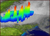
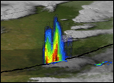
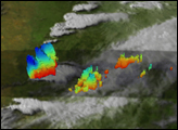
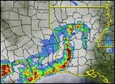
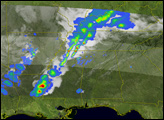
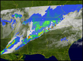
Like a deadly armada advancing on the South, this TRMM image shows a dramatic line of towering, severe thunderstorms on May 6, 2003. The storms were part of a three-day, widespread outbreak of severe weather across the southern Plains and southeast during May 4-May 6. The Tropical Rainfall Measurement Mission (TRMM) satellite uses the Precipitation Radar, designed and built by the Japanese space agency NASDA, to measure precipitating ice and rainfall inside clouds. It is the only weather radar used in space. This particular overpass occurred at 5:16 pm EDT as the line of menacing storms was producing numerous episodes of damaging hail, strong winds, and tornadoes.
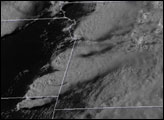
The colors indicate the relative height of the rain cells embedded within the squall line, with reds indicating cell tops in the range of 13-16 kilometers above the ground. Underneath this cross-section is a natural-color image based on GOES-12 satellite data. The gray swath across the center of the image shows the path of the TRMM satellite.
For more images of the severe weather outbreak as viewed by TRMM, visit the TRMM website.
Image courtesy of Hal Pierce, NASA Goddard Space Flight Center.