animations
ÿÿsmall (1 MB MOV)
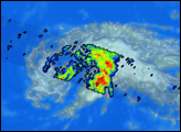
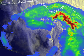
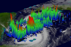
This Tropical Rainfall Measuring Mission (TRMM) satellite image of Tropical Storm Kyle was captured on October 3, while the storm was still far from land. The swath of the orbiter can be seen across the swirl of Kyle’s cloud tops, where the different colors reveal rain intensity and structure. In this image blue indicates light rain and red indicates heavy rain. While rainfall in the eastern rain band appears impressive, TRMM unveils why Kyle ultimately failed to strengthen--poor organization of rain around the eye. The rain bands do not form a completely circular eyewall, and only light, sporadic rains are found in the northwestern quadrant. Since hurricanes derive their energy from condensation of water vapor into rain, the lack of organized rains all the way around the inner core of Kyle suggest that this storm’s ?heat engine? was not operating at peak capacity.
While TRMM occasionally captures spectacular images of intense rain clouds within the interior of powerful Atlantic hurricanes, it is also important to study marginal storms such as Kyle to determine why some tropical disturbances thrive while others fail. Ultimately this knowledge will lead to better predictions of which tropical cyclones pose the greatest U.S. threat.
The TRMM satellite is a joint effort of both NASA and the Japanese space agency NASDA. More images and information on Atlantic hurricanes as seen by TRMM can be found at trmm.gsfc.nasa.gov.Image courtesy of Hal Pierce and Jeff Halverson, TRMM Science Team at NASA GSFC.