Red-hot streams of molten rock sliced across the hard, black landscape. The lava hissed violently as it dropped into the Pacific near Hawaii’s Volcanoes National Park. Nearby passengers aboard a small boat could feel its 2,000-degree heat warming their faces.
In the following days, a small new delta formed, jutting into the sea southeast of the Pu’u O’o volcanic cone. Hawaii had grown again, gaining a few more feet in a process that began tens of millions of years ago and thousands of miles below Earth’s surface.
The story of the Hawaiian Islands begins at a hotspot, a point where magma from Earth’s mantle penetrates the crust. As the Pacific tectonic plate has moved over it, this stationary jet of magma has acted like a laser cutter, punching holes in the seafloor and ejecting molten rock to create an archipelago. Over the years, these islands have grown and their contours have changed. During the frequent eruptions of the various volcanoes, lava has devoured trees and structures, but also built new land. Winds and ocean waves have carved the edges, creating cliffs.
The photograph (STS61A-50-57) at the top of this page dates back to November 1, 1985, when it was taken by an astronaut on the space shuttle. Twenty-eight years later, the Operational Land Imager (OLI) on the Landsat 8 satellite acquired several natural-color views (second image) that have been made into a mosaic of the park.
This turbulent landscape has been home to people for centuries. Hawaii’s first settlers likely came from the Marquesas Islands around 500 C.E. A second migration, from Tahiti, began sometime between 1200 and 1400 C.E.
In 1823, William Ellis, an English missionary, became one of the first Europeans to feel the hot breath of Kilauea volcano. After an hours-long climb—through a tangle of sopping rainforest and then across a rocky, moon-like landscape quenched by acid rain from the volcano’s sulphuric fumes—Ellis reached the edge of the crater. He stood rooted to the spot. Below, a “cauldron of lava” boiled. Dense columns of smoke and vapor rose from the abyss. Ellis waited without speaking. He listened to “the constant roaring of the vast furnaces below.”
For hundreds of years, visitors have come to the park on Hawaii’s largest island to peer down into the abyss. Volcanoes National Park was established on August 1, 1916. In 1987, the park became a World Heritage Site. 2016 has been marked by centennial celebrations.
Volcanoes National Park includes the Earth's largest volcano, Mauna Loa. It stands 13,677 feet (more than 4,000 meters) above sea level, according to the National Park Foundation. But what visitors see merely represents the tip of the mountain. If you measure from the sea floor, Mauna Loa’s summit stretches roughly 56,000 feet (17,000 meters) above its base. That’s more than 27,000 feet (8,230 meters) higher than Mount Everest.
The Mauna Loa Observatory, a small white orb at the end of a long thread (Mauna Loa Observatory Road), has been measuring carbon dioxide levels from near the volcano’s summit since the 1950s. Dried lava flows appear like deep, dark scratches in the surrounding hills.
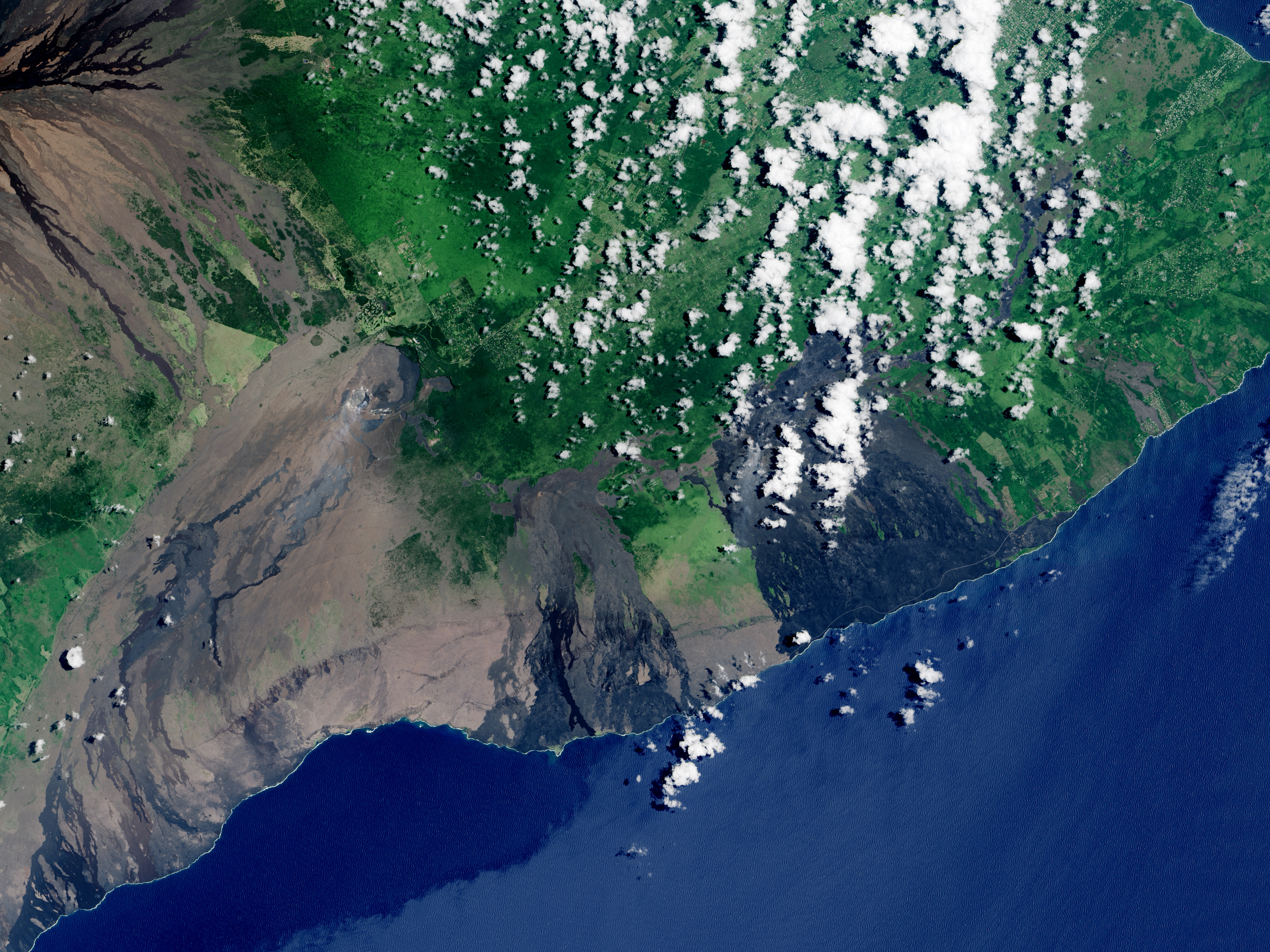
Neighboring Kilauea is the world’s most active volcano, and one of the best-studied on the planet. Easy road access has led some to call it a “drive-up” volcano.
But visitors ignore warning signs at their own peril. Park rangers caution that the ground may be unstable underfoot, as a crust of hardened lava may sit atop a hot, molten river or a hollow air tunnel. Acidic smoke, laden with lung-irritating particles, billows out of craters.
NASA Earth Observatory images by Jesse Allen, using Landsat data from the U.S. Geological Survey and Space Shuttle photograph STS61A-50-57 which was acquired on November 1, 1985, with a Hasselblad medium format camera with a 250 millimeter lens, and is provided by the ISS Crew Earth Observations Facility and the Earth Science and Remote Sensing Unit, Johnson Space Center. Caption by Pola Lem.