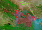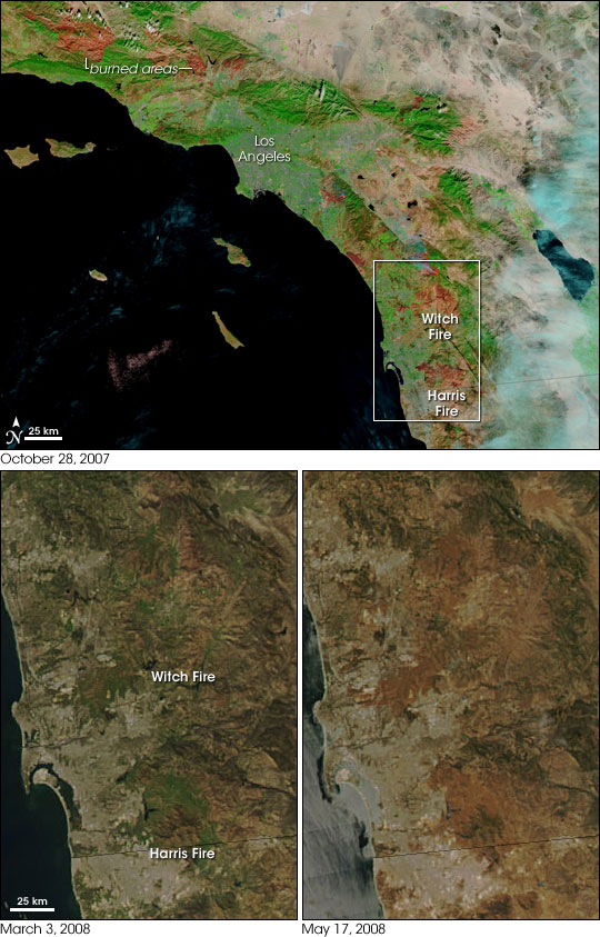
In late October 2007, a firestorm exploded across southern California. Fueled by dry vegetation and powerful Santa Ana winds, California’s wildfires scorched nearly 30,000 acres (120 square kilometers) in the autumn of 2007. By March of the following year, the burned areas had re-grown with lush vegetation, but by May 2008, that vegetation had dried, providing potential fuel for another firestorm.
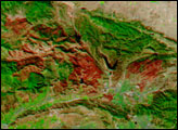
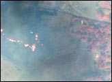
The Moderate Resolution Imaging Spectroradiometer (MODIS) on NASA’s Terra and Aqua satellites collected these observations of the area. Terra acquired the top image on October 28, 2007, and Aqua acquired the bottom images on March 3 and May 17, 2008. The top image is made from a combination of visible and infrared light to show the extent of the wildfires. Urban areas appear gray, unburned vegetated areas appear bright green, and burned areas appear brick red. The bright red-pink specs in the burned areas suggest lingering flames. The bottom images are photo-like images of the area the following year. Whereas much of the area appears deep green on March 3, brown predominates on May 17, shortly after the spring rains ended.
Southern California’s native vegetation includes fire-tolerant grasses, deep-rooted shrubs, and cacti, which are vulnerable to wildfires for about six months out of every year. Human settlement, however, introduced non-native plants. These plants germinate faster than California’s natives, which means that burned areas often get colonized by invasive species of grass and weeds. Besides germinating faster, the non-native plants also dry out faster, making non-native plants more vulnerable to fire throughout the year.
Not only does the invasive vegetation have a greater propensity for burning, but human presence in the chaparral ecosystems of southern California has probably increased likelihood of fires starting. Before California’s human population reached twentieth-century size, lightning started most of the area’s fires. Since the area urbanized starting in the 19th century, people began to cause fires, both accidentally and intentionally, and the fires became more frequent.
NASA images courtesy the MODIS Rapid Response Team at NASA GSFC. Caption by Michon Scott. Thanks to Dr. Liam Gumley, University of Wisconsin-Madison, for identifying the green-up in MODIS Direct Broadcast Data published at MODIS Today.