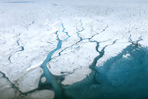
Toward the end of the 21st century, melting from the Greenland Ice Sheet could result in global sea level rise of 4-21 centimeters (2-8 inches), according to the Fifth Assessment Report from the Intergovernmental Panel on Climate Change. Toward refining that estimate, some scientists are taking a close look at the colorful plumes that pepper the ocean around Greenland's perimeter.
About half of the mass lost from the Greenland Ice Sheet is from icebergs calving from glaciers; the other half is lost via meltwater runoff either from the top of the ice or from below (subglacial). According to Vena Chu of University of California, Los Angeles, one of the biggest science questions relating to the ice sheet is: what is the contribution to sea level rise from meltwater?
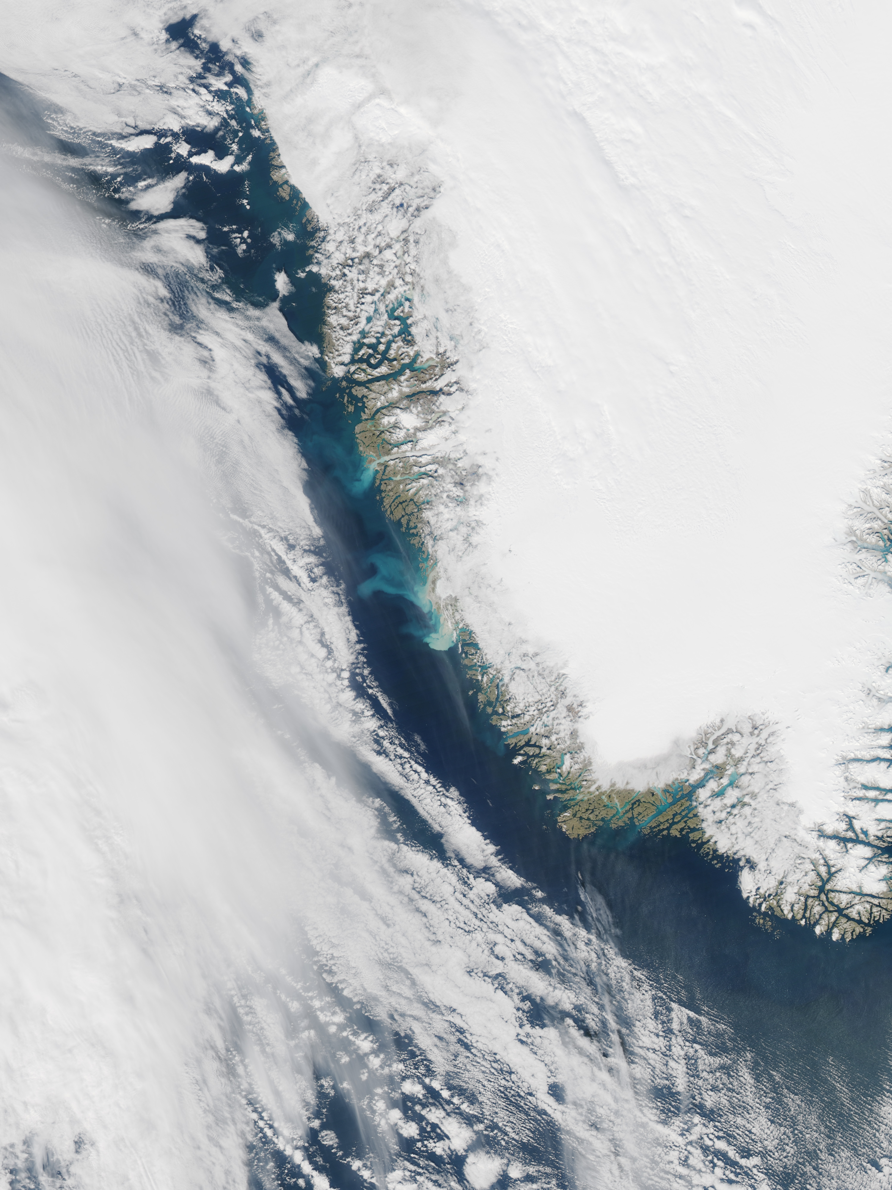
Measuring the amount of meltwater leaving the ice sheet—as opposed to water that is stored or refrozen after melting—is a huge challenge. One way to better understand the hydrology of the ice sheet is by observing the buoyant bits of dust, minerals, and soil that exit the fjords of large glaciers. "The sediment wonderfully stands out behind the blue marine waters," Chu said, "and makes it easy to see in remotely sensed satellite imagery."
Scientists working in 2008 in Greenland's Kangerlussuaq Fjord found that higher sediment concentrations coincided with lower salinity levels in coastal waters, confirming that the presence of a sediment plume is a strong marker for subglacial freshwater leaving the ice sheet. Subsequent research showed that satellite imagery can be used to map the size and location of these sediment plumes.
"This is especially important in fjords of marine-terminating glaciers, where we have no way of measuring the amount of runoff, as opposed to land-terminating glaciers that end in rivers, where it is difficult but possible to measure runoff more traditionally," Chu said.
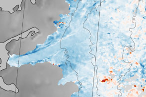
The image above, acquired by the Moderate Resolution Imaging Spectroradiometer (MODIS) on NASA's Aqua satellite on September 9, 2014, shows sediment plumes from meltwater exiting glaciers in southwest Greenland.
The sediment comes from the glacier scraping and scouring the bedrock as it moves downhill. Sediment-laden water at the coast indicates that meltwater from the surface of the ice sheet—which starts out relatively clean—has fallen through channels in the glacier all the way down to the bottom, then flowed between the ice and bedrock to the ocean. The phenomenon is important for understanding not only how much meltwater exits into the ocean, but also for understanding how it lubricates the ice-bedrock interface and affects the speed of glaciers.
Some aspects of sediment plumes, however, remain a challenge to study. Meltwater from some glaciers enters the ocean hundreds of meters below the fjord surface. In those cases, sediment visible at the surface is only part of the picture.
"Not all of the sediment makes it to the surface, a lot of it settles out," Chu said. "It is important that we make more detailed oceanographic studies looking at the vertical structure of these plumes."
NASA Earth Observatory image by Jesse Allen, using data from the Level 1 and Atmospheres Active Distribution System (LAADS). Caption by Kathryn Hansen.