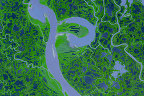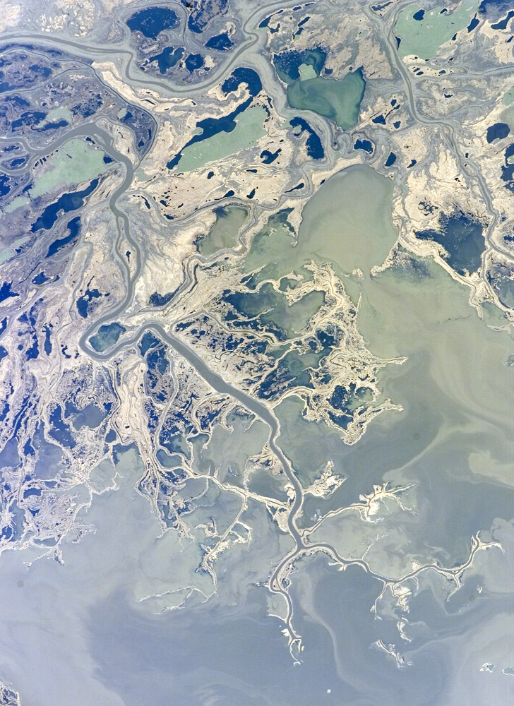
This astronaut photograph highlights a portion of the Saskatchewan River delta extending into Cedar Lake in the province of Manitoba, Canada. The Saskatchewan River watershed extends from the Rocky Mountains of Alberta through the plains of Saskatchewan and Manitoba to the east. Flooding of the Cedar Lake basin following the construction of the Grand Rapids Dam (to the southeast, not shown) in the 1960s created shallow, muddy lakes and bogs (dark green and blue irregular areas).
The velocity of Saskatchewan River slows significantly as the river enters Cedar Lake; as the velocity slows, silt, clay, sand, and gravel are deposited at the river mouth. These deposits (light tan and gray in the image), called alluvium by geologists, border the active channels of the Saskatchewan and Summerberry Rivers.
As the deposits accumulate, they impede the river’s flow. Old channels are abandoned, and new ones form as the river seeks an easier path into the lake. Through this process (known as avulsion), the delta builds and branches out over time. A typical “bird’s foot”-shaped delta is currently forming at the mouth of the Saskatchewan River (image lower right). The bird’s-foot structure is approximately 13 kilometers wide. The Mississippi River’s active delta has the same general form, but it is much larger—approximately 50 kilometers wide.
The bogs in the Saskatchewan delta are saturated enough that peat (dead plant material that accumulates in a water-saturated environment) has formed. Over long periods of time and under the right geological conditions, peat deposits can become coal. The accumulation of plant and animal remains in the water-logged, oxygen-poor environment greatly slows down decay. In addition to setting the stage for coal formation, these conditions also preserve fossils of many kinds. The delta sediments at Cedar Lake are a rich source of fossil-bearing amber that was preserved along with coal deposits during the Late Cretaceous (about 65–99 million years ago). These deposits were not formed locally, however; they have washed into the delta from coal deposits over a thousand kilometers to the west of Cedar Lake.
The featured astronaut photograph ISS015-E-7649 was acquired May 11, 2007, by the Expedition 15 crew with a Kodak 760C digital camera using a 400 mm lens. The image is provided by the ISS Crew Earth Observations experiment and the Image Science & Analysis Laboratory, Johnson Space Center. The image in this article has been cropped and enhanced to improve contrast. The International Space Station Program supports the laboratory to help astronauts take pictures of Earth that will be of the greatest value to scientists and the public, and to make those images freely available on the Internet. Additional images taken by astronauts and cosmonauts can be viewed at the NASA/JSC Gateway to Astronaut Photography of Earth.