Editor’s Note: Today’s caption is the answer to Earth Observatory’s monthly satellite puzzler.
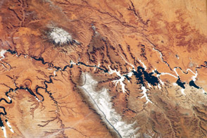
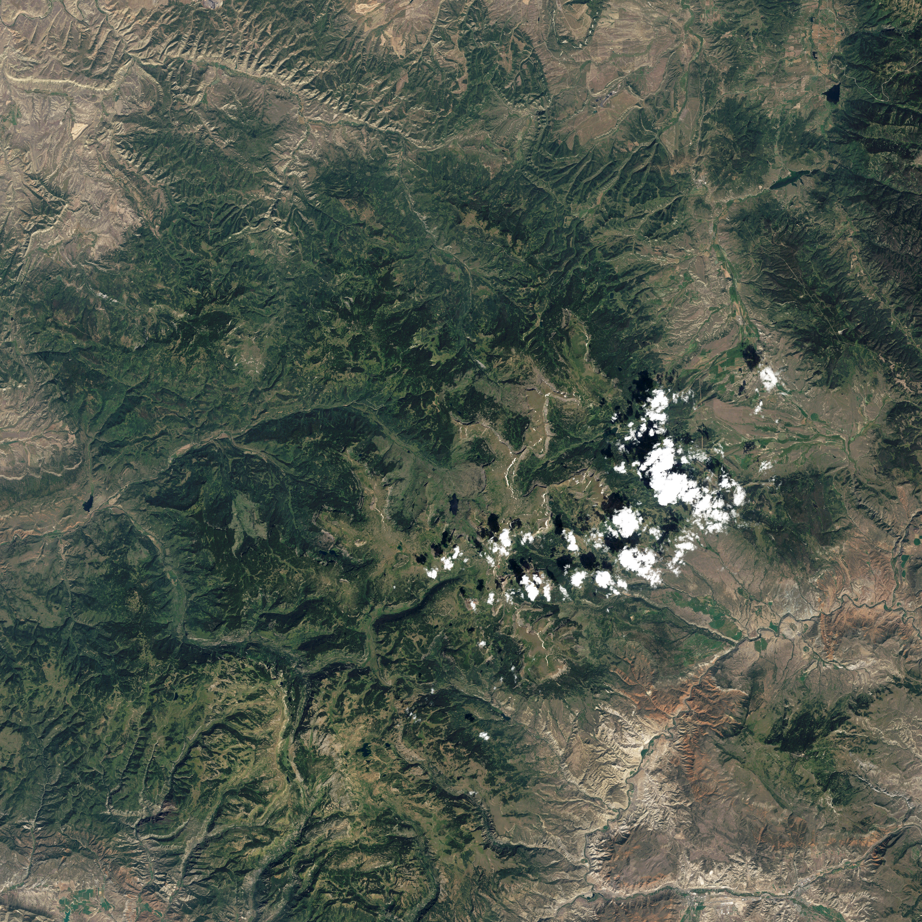
The Colorado Rockies bring jagged ridges and pyramid-shaped peaks to mind, but not all of the state’s mountains fit that description. North of Glenwood Springs and east of Meeker, a series of flat-topped plateaus dominate the skyline.
The Thematic Mapper (TM) aboard the Landsat 5 satellite acquired this view of the Flat Tops and the surrounding area on September 4, 2011. An optical illusion called relief inversion, caused by the angle of sunlight and shadows, makes the treeless plateau appear lower than the surrounding landscape. In fact, Flat Top’s plateau is much higher, standing about 3,750 meters (12,300 feet) above sea level and 300 meters (1,000 feet) above the adjacent lowlands.
The mountain is part of the Flat Tops Range, a spectacular group of mountains that were built on top of the White River Plateau by volcanic activity. In contrast to the explosive eruptions that defined landscapes in other parts of the Rockies, Flat Tops experienced repeated eruptions that sent lava flowing across the landscape in broad rivers between 24 million and 8 million years ago. The flows laid down thick stacks of basalt, a type of volcanic rock that is more resistant to erosion than the underlying sedimentary rocks. Over time, even as the forces of water, wind, and ice have worn the surrounding sedimentary landscape away, caps of basalt have preserved the shape of the plateau.
Ice has played a key role in sculpting the area as well. Tens of thousands of years ago, glaciers covered the top of the plateau and spilled into the surrounding valleys, grinding away at their slopes and creating amphitheater-like features called cirques. The thin ridge of basalt called the Devils Causeway formed when cirques on opposites sides of the ridge eroded so much of the plateau that they nearly met. Today, the Devils Causeway offers a harrowing experience for hikers. At its narrowest point, the rock bridge is just a meter wide and has vertical cliffs that drop hundreds of meters on either side.
While tundra grasses thrive above the tree line at the top of the plateau, the surrounding lowlands are home to conifers including Englemann Spruce, Sub Alpine Fir, Lodgepole Pine, and Blue Spruce. In the image, conifer-dominated forests are darker green, while the lighter green along the southern and western facing slopes are mainly comprised of Aspen, a deciduous hardwood tree.
One tree from this part of Colorado received special attention in 2012. The National Park Service selected a 22-meter Engelmann Spruce, grown near Ripple Creek Lodge, as the Christmas tree for the U.S. Capitol. The tree was harvested from Blanco Ranger District of White River National Forest on November 2, took a meandering journey across the country via truck, and was officially lit by Speaker of the House John Boehner in December.
“We wanted the perfect conical shape and height, of course, but logistics were also key. We had to pick a tree that that a crane could access and swing onto a flatbed trailer,” said Dan Schwartz, the owner of Creek Lodge. You can watch a video that details the tree’s journey here.
NASA Earth Observatory image by Jesse Allen and Robert Simmon, using Landsat data from the U.S. Geological Survey. Adam Voiland. Congratulations to Alan for being our first reader to solve the puzzler.